| |
|
| | Outdoors people generally like this part of Oregon. Each wilderness hiking trail in Oregon is different from the others. Hey, time for a trek don’t you think? Lost Peak Trail in Klamath County, Oregon is just the place. There is only one trailhead, so in and out is the way to backcountry hike it normally. This is one of many backcountry hiking trails in the surrounding area. Trekking here in Oregon is a splendid way to spend some time. Summertime highs at Lost Peak Trail typically tend to be in the 80's. Once the sun is down it dips down to the 40's. |
|
The wintertime comes with highs in the 40's; overnight lows during the wintertime for Lost Peak Trail tend to be in the 20's. The length of this wilderness hiking trail is about average having an average number of uphill miles which makes it a good backcountry hiking trail for
| | experienced backcountry hikers in great shape. Lost Peak Trail gets a normal amount of precipitation; the wettest month of the year is regularly November, that's the one that rains the most, and July is the month with the least moisture. The time needed for this backcountry hike is roughly 6 hours, but you never know stuff could go wrong and you could get stuck so be prepared for that. There are wilderness hiking trails all over Oregon, and Lost Peak Trail in Klamath County is one of them. A long drive separates Klamath Falls from Lost Peak Trail, but | |
|
there's glorious natural splendor right here for you along it. The trail stays roughly within the same elevation zone the whole time which means the conditions are about the same from start to finish. Now this backcountry trail is pretty long, so don't forget to pack enough supplies.
Please follow all local rules about fires and camping. Lost Peak Trail has a total elevation difference of 1,319 feet, and that is about average. Being 6.8 miles long it's an average length trail. At parts of the year this area sees very little rain, so do check for current fire
restrictions before you go if you plan to bring a stove or make a camp fire. Trekking here in the Southern Cascade Range is the best way to enjoy these peaks.
Briefly about the general area: Looking for a good trip? Crater Lake National Park is relatively close to Lost
Peak Trail; there's some flowing water nearby, Long Creek is a stream you can pop by during your stay. Stay the night at White Pine Campground, and don't leave Lost Peak Trail without first paying a visit to Christis Spring. All year is a glorious time in the Southern Cascade
Range if you like the outdoors. You'll need more than a day to explore everything Lost Peak Trail has to offer, you can camp at Saddle Campground, and Horse Creek is one of the streams close by that might be worth going to.
|
|
Location of Trailhead: Latitude 42.4525, Longitude -122.2167 - - Directions and Road Map
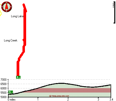
Total in and out hiking length = 6.8 miles
Total climbing distance = 3.2 miles
Difficulty : Difficult
Casual Hiking Pace:
6 hours
Fast Hiking Pace:
4 hours
Total elevation difference: 1319 feet

Lithia Springs Resort And Gardens, Ashland
|
28 miles away
Hello, from Ashland, Oregon! Imagine, at the end of a long day's travel, relaxing in a 2 person whirlpool filled with hot mineral water, right in your own room. Lay back, Let the relaxing quality of t...
|
| |
Americas Best Value Inn, Klamath Falls
|
31 miles away
Welcome to the Americas Best Value Inn of gorgeous Klamath Falls, Newly renovations, See our new room with Big TV DVD and VCR. Located just off Highway 97 and 140 approximately one miles from O.I.T. A...
|
|
User input for Lost Peak Trail, Southern Cascade Range, Klamath County, Oregon:

Outdoors Recreation Near Klamath Falls, Oregon Very comprehensive list of a variety of outdoors recreation in the vicinity of Klamath Falls, Oregon, the metro area neareast to Lost Peak Trail. Find info on campgrounds, hiking trails, ski resorts, lakes, beaches, parks, whitewater and more.
|
Current weather conditions at Lost Peak Trail, Southern Cascade Range, Klamath County, Oregon

Local climate location: PROSPECT 6 miles away

           
| |
Klamath Falls Super 8 Motel, Klamath Falls
|
31 miles away
AAA approved. Conveniently located on Hwy 97, near Hwy 140, and Hwy 66. Downtown just minutes away. Klamath Medical Center Oregon Institute of Technology, State and National Forestry offices nearby. L...
|
Quality Inn Klamath Falls, Klamath Falls
|
32 miles away
Walking distance to downtown shops, nature trail, Favell Museum, Baldwin Museum, Veterans Park and Lake Ewanna. FREE high speed internet access available in some rooms. Pet accommodation: 10.00/night,...
|
|
More Hotels and Campgrounds Near Lost Peak Trail, Southern Cascade Range, Klamath County, Oregon
| |
| |
 |
|
| These outdoors activities are available near Lost Peak Trail. |
| | Trails Near Lost Peak Trail:
 |
Four Mile Lake Trail, Klamath County
County
, 1 miles away, 7.4 hiking miles, 434 feet elevation difference |
 |
Blue Canyon Trail, Klamath County
County
, 4 miles away, 10 hiking miles, 763 feet elevation difference |
 |
Blue Rock Trail, Klamath County
County
, 4 miles away, 7.6 hiking miles, 925 feet elevation difference |
 |
Cold Spring Trail, Klamath County
County
, 5 miles away, 6.5 hiking miles, 937 feet elevation difference |
 |
Red Lake Trail, Klamath County
County
, 5 miles away, 10.3 hiking miles, 1759 feet elevation difference |
 |
Twin Ponds Trail, Klamath County
County
, 5 miles away, 5.1 hiking miles, 1377 feet elevation difference |
 |
Pelican Butte Trail, Klamath County
County
, 5 miles away, 10.4 hiking miles, 3325 feet elevation difference |
|
| | Hotels Near Lost Peak Trail:
 |
Lithia Springs Resort And Gardens, Ashland
, 28 miles away |
 |
Americas Best Value Inn, Klamath Falls
, 31 miles away |
 |
Klamath Falls Super 8 Motel, Klamath Falls
, 31 miles away |
 |
Quality Inn Klamath Falls, Klamath Falls
, 32 miles away |
 |
Econo Lodge Klamath Falls, Klamath Falls
, 32 miles away |
|
|
|
 |
|