| |
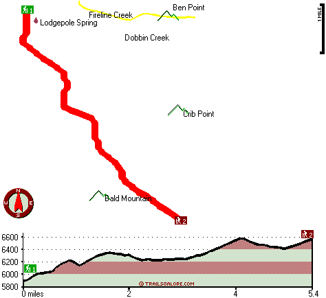
Lodgepole Trail has a total elevation difference of 774 feet which is lower than average. This hike should take you about 1.5 days, so it's a tremendous thing if your backpack is big enough to do the job. This area does get very dry sometimes, so make sure you check current conditions and fire restrictions with local forest authorities before you head out. Lodgepole Trail is a two ended great outdoors trail with two trailheads, so if you can get a ride from someone, you can walk it just one way. This is a long hiking and backpacking trail, so make sure you bring plenty of supplies. You spend the whole backcountry walk in roughly the same elevation zone, so you won’t have to worry about different climate zones along your backcountry walk. Lodgepole Trail is 10.8 miles long; it's considered a longer backcountry walk.
|
Trailhead 1 to Trailhead 2:
Total hiking length = 5.4 miles
Total climbing distance = 3.2 miles
Difficulty : Medium
Casual Hiking Pace:
5.5 hours
Fast Hiking Pace:
3 hours
Trailhead 2 to Trailhead 1:
Total hiking length = 5.4 miles
Total climbing distance = 1.6 miles
Difficulty : Easy
Casual Hiking Pace:
4.5 hours
Fast Hiking Pace:
2.5 hours
| | Trailhead 1 back to Trailhead 1:
Total hiking length = 10.8 miles
Total climbing distance = 4.8 miles
Difficulty : Difficult
Casual Hiking Pace:
1.5 days
Fast Hiking Pace:
6.5 hours
Trailhead 2 back to Trailhead 2:
Total hiking length = 10.8 miles
Total climbing distance = 4.8 miles
Difficulty : Difficult
Casual Hiking Pace:
1.5 days
Fast Hiking Pace:
6.5 hours
|
Total elevation difference: 774 feet
|


