| |
|
| | In Oregon you never run out of outdoors fun. Gotta get out of the city man, and Larison Creek Trail in Lane County, Oregon is a good place for getting out. Larison Creek Trail is a wilderness trail quite far from Eugene-Springfield, but it is a good getaway from the city. This great outdoors trail has two trailheads, so if you can get a ride from someone, you can walk it just one way. Even though this is not a very long wilderness trail you should still bring some emergency supplies just in case something happens. During the warm months, highs regularly |
|
are in the 80's at Larison Creek Trail, and throughout summer nights temperatures are in the 50's. The winter brings highs down to the 40's while Larison Creek Trail overnight low temperatures throughout the winter are in the 30's. With its 3.2 miles of walking distance it's a
| | short backcountry hiking trail. Going for a backcountry trek here in Oregon is always a cool thing to do. There are plenty of great outdoors trails in Oregon; each one of them has something unique to offer. And keep in mind that there could be temporary safety restrictions in place. The backcountry hiking trail stays roughly within the same elevation zone the whole time, so you won’t have to worry about different climate zones along your walk. This backcountry hiking trail is on the short side with an average amount of climbing distance which makes it a magnificent | |
|
great outdoors hiking trail for the average person looking for a magnificent adventure. The total elevation difference for Larison Creek Trail is 191 feet which is a lower than average number. Trails like this one here in the Central Cascade Range are a very good way to see these
mountaintops. There are not too many great outdoors hiking trails in this region. Great outdoors trails are glorious and plentiful in Oregon; among these are Larison Creek Trail in Lane County. Larison Creek Trail frequently gets a lot of rainfall; the month with most of the rain
is November; July on the other hand is the driest. This backcountry hike shouldn't take more than 3 hours, but you never know stuff could go wrong and you could get stuck so be prepared for that. This area does get very dry sometimes, so don’t forget to check for any current fire
restrictions before you go.
Briefly about the general area: These mountains rock, just explore all the entertaining stuff to do in the Central Cascade Range. Camping at Larison Creek Trail is glorious fun, Oakridge Mobile Home Park is a glorious local campground, and
get your pulse rate up on the great whitewater of Salmon Creek. If you came for an overnight stay Errin Campground is a nice spot to camp, and there's whitewater on Willamette River - Middle Fork for all you adrenaline rush seekers.
|
|
Location of Trailhead 1: Latitude 43.7093, Longitude -122.4859 - - Directions and Road Map
Location of Trailhead 2: Latitude 43.7027, Longitude -122.5128 - - Directions and Road Map

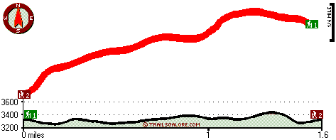
Trailhead 1 to Trailhead 2: Total hiking length = 1.6 miles Total climbing distance = .8 miles Difficulty : Medium Casual Hiking Pace:
1.5 hours
Fast Hiking Pace:
1 hours
Trailhead 2 to Trailhead 1: Total hiking length = 1.6 miles Total climbing distance = .6 miles Difficulty : Medium Casual Hiking Pace:
1.5 hours
Fast Hiking Pace:
.5 hours
| | Trailhead 1 back to Trailhead 1: Total hiking length = 3.2 miles Total climbing distance = 1.4 miles Difficulty : Medium Casual Hiking Pace:
3 hours
Fast Hiking Pace:
2 hours
Trailhead 2 back to Trailhead 2: Total hiking length = 3.2 miles Total climbing distance = 1.4 miles Difficulty : Medium Casual Hiking Pace:
3 hours
Fast Hiking Pace:
2 hours
|
Total elevation difference: 191 feet

Best Western Oakridge Inn, Oakridge
|
2 miles away
This Oakridge, Oregon hotel offers a complimentary continental breakfast each morning and convenient access to a variety of outdoor activities. Discover the Best Western Oakridge Inn, nestled agains...
|
| |
Super 8 Creswell, Creswell
|
37 miles away
AAA approved - SuperStart Breakfast, Jacuzzi Rooms, Wi-Fi, Outdoor Seasonal Pool, Conveniently Located on I-5 at Exit 182, Pet Friendly, Friendly Staff, AAA/AARP Rates Available...
|
|
User input for Larison Creek Trail, Central Cascade Range, Lane County, Oregon:

Outdoors Recreation Near Eugene-Springfield, Oregon Very comprehensive list of a variety of outdoors recreation in the vicinity of Eugene-Springfield, Oregon, the metro area neareast to Larison Creek Trail. Find info on campgrounds, hiking trails, ski resorts, lakes, beaches, parks, whitewater and more.
More Hotels and Campgrounds Near Larison Creek Trail, Central Cascade Range, Lane County, Oregon
| |
|
| These outdoors activities are available near Larison Creek Trail. |
| | Trails Near Larison Creek Trail:
 |
Dinner Ridge Way, Lane County
County
, 2 miles away, 7.7 hiking miles, 4056 feet elevation difference |
 |
Packard Creek Trail, Lane County
County
, 4 miles away, 4.9 hiking miles, 2844 feet elevation difference |
|
| | Whitewater Near Larison Creek Trail:
 |
Willamette River - Middle Fork, Lane County
County
, 3 miles away, Class II - 12.5 miles long (Hills Creek Dam to Lookout Point Reservoir) |
 |
Salmon Creek, Lane County
County
, 8 miles away, Class II-V - 12 miles long (Top of Upper Salmon Creek Gorge to Oakridge) |
|
| | Hotels Near Larison Creek Trail:
 |
Best Western Oakridge Inn, Oakridge
, 2 miles away |
 |
Super 8 Creswell, Creswell
, 37 miles away |
 |
Moonstone Village Green Resort, Cottage Grove
, 38 miles away |
 |
Comfort Inn Cottage Grove, Cottage Grove
, 38 miles away |
 |
Holiday Inn Express Cottage Grove, Or, Cottage Grove
, 38 miles away |
|
|
|
 |
|