Oregon hiking trails - Lake Creek Trail, Blue Mountains, Grant County

   
  Outdoors people generally like this part of Oregon. Far from modern life you come across Lake Creek Trail, and when you trek it you're always having a splendid time. Backcountry backpacking here in Oregon is a fine way to spend some time. The time needed for this backcountry walk is roughly 7 hours, but you never know stuff could go wrong and you could get stuck so be prepared for that. There are many nice hiking and backpacking trails in Oregon; Lake Creek Trail in Grant County is one of them. The length of this backcountry hiking trail is about average
    having an average number of uphill miles which makes it an excellent wilderness hiking trail for experienced hikers in good shape. This great outdoors trail has two trailheads which means you have the option of backpacking it one way if you have someone to pick you up at the other
end. Keep in mind that this is a long hiking trail, so do pack enough food to last the whole trip. Each hiking and backpacking trail in Oregon has its own unique prettiness. Different parts of Lake Creek Trail are at very different elevations, and that means that some parts of the trail could be very different from other parts of it. The charming backcountry hiking trails of the Blue Mountains are a very glorious way to see these highlands. Lake Creek Trail gets very little rain; the month of May is the wettest with most of the rain, and July on the  
other hand is the driest. For the duration of the summertime, highs commonly are in the 80's at Lake Creek Trail. Summer nighttime lows fall down to the 40's. High temperatures during the wintertime are normally in the 40's, and nighttime lows during the wintertime for Lake Creek Trail tend to be in the 20's. With its 7.8 miles of walking distance it's a mid length trek. Spending too much time indoors got you down? No problem, Lake Creek Trail in Grant County, Oregon is a splendid choice. There are so many wilderness hiking trails in this area. At parts of the year this region sees very little rain, so do check for current fire restrictions before you go if you plan to bring a stove or make a camp fire. Please follow all local rules about fires and camping. This great outdoors trail has a total elevation difference of 1,998 feet, and that is about average.

Briefly about the general area:
You just can't imagine the amount of outdoors exciting things the Blue Mountains has to offer. Wickiup Campground is a great campground here; Indian Springs is a great local attraction. This river is a great place to visit. Big Riner Basin is a nice spot here at Lake Creek Trail; Little Riner Basin is right here at Lake Creek Trail.
If you came for an overnight stay Indian Springs Campground is a great spot to camp, and Strawberry Falls is always fun to check out.

Location of Trailhead 1: Latitude 44.2513, Longitude -118.6561
- - Directions and Road Map

Location of Trailhead 2: Latitude 44.2791, Longitude -118.6976
- - Directions and Road Map


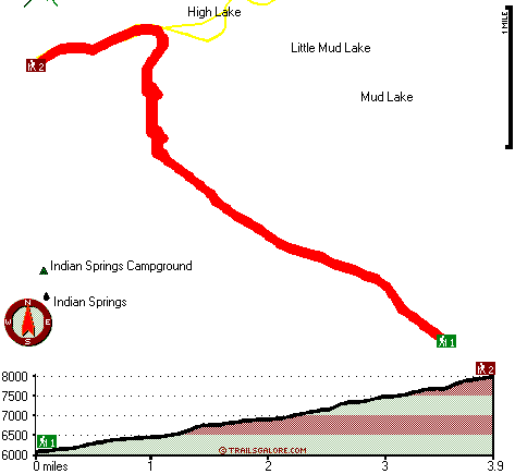
Trailhead 1 to Trailhead 2:
Total hiking length = 3.9 miles
Total climbing distance = 3.2 miles
Difficulty : Difficult
Casual Hiking Pace: 4.5 hours
Fast Hiking Pace: 2.5 hours

Trailhead 2 to Trailhead 1:
Total hiking length = 3.9 miles
Total climbing distance = 0 miles
Difficulty : Easy
Casual Hiking Pace: 2.5 hours
Fast Hiking Pace: 1 hours
    Trailhead 1 back to Trailhead 1:
Total hiking length = 7.8 miles
Total climbing distance = 3.2 miles
Difficulty : Difficult
Casual Hiking Pace: 7 hours
Fast Hiking Pace: 4.5 hours

Trailhead 2 back to Trailhead 2:
Total hiking length = 7.8 miles
Total climbing distance = 3.2 miles
Difficulty : Difficult
Casual Hiking Pace: 7 hours
Fast Hiking Pace: 4.5 hours

Total elevation difference: 1998 feet


Best Western John Day Inn, John Day
21 miles away
This charming John Day, Oregon hotel is minutes from a variety of outdoor activities and walking distance from many local shops and restaurants. Located in Eastern Oregon's beautiful John Day Valley...
  
Americas Best Value Inn, John Day
21 miles away
User input for Lake Creek Trail, Blue Mountains, Grant County, Oregon:

Submit Input:
Your Name:
Write or Paste Input here:

Upload picture:      Review Guidelines


Outdoors Recreation Near La Grande, Oregon
Very comprehensive list of a variety of outdoors recreation in the vicinity of La Grande, Oregon, the metro area neareast to Lake Creek Trail. Find info on campgrounds, hiking trails, ski resorts, lakes, beaches, parks, whitewater and more.

Current weather conditions at Lake Creek Trail, Blue Mountains, Grant County, Oregon
WXPort

Local climate location: JOHN DAY 7 miles away

Burns - Days Inn Ponderosa, Burns
43 miles away
Days Inn - Burns is located in Downtown Burns only 3/4 of a mile from Old Camp Casino. We are within walking distance to shopping, a theater and laundry facilities are less than 100 yards away. Days...

Americas Best Inns-Burns, Burns
44 miles away
America's Best Inn and Suites have become known for comfort, value and the friendly attention of a welcoming staff that cares. At America's Best Inns and Suites, we keep your comfort in mind and offer...

More Hotels and Campgrounds Near Lake Creek Trail, Blue Mountains, Grant County, Oregon

OTHER_INFO
  Blue Mountains Campgrounds
Complete list of all the campgrounds in the Blue Mountains.

Blue Mountains Outdoors Info
Complete outdoors info for the Blue Mountains.

Oregon Hiking Trails
Complete list of all hiking trails in Oregon

Books about hiking trails in Oregon
List of books available on Amazon.com about hiking trails in Oregon.

Oregon Outdoors Index
This is a very comprehensive index of outdoors activities in the great state of Oregon.


TOPO
High quality water resistant topo map of Lake Creek Trail, Blue Mountains, Grant County, Oregon.

OUTDOORS_GUIDE
These outdoors activities are available near Lake Creek Trail.
 Trails Near Lake Creek Trail:
Slide Basin Trail, Grant County County , 1 miles away,  7.6 hiking miles, 1575 feet elevation difference
Strawberry Basin Trail, Grant County County , 2 miles away,  12.6 hiking miles, 2804 feet elevation difference
Meadow Fork Trail, Grant County County , 3 miles away,  8.6 hiking miles, 2337 feet elevation difference
Twin Springs Trail, Grant County County , 4 miles away,  3.6 hiking miles, 1157 feet elevation difference
Skyline Trail, Grant County County , 4 miles away, 14.8 hiking miles, 2722 feet elevation difference
Onion Creek Trail, Grant County County , 4 miles away, 7 hiking miles, 1861 feet elevation difference
Pine Creek Trail, Grant County County , 4 miles away,  7.8 hiking miles, 1148 feet elevation difference
 Camp Grounds Near Lake Creek Trail:
Indian Springs Campground, Grant County, 1 miles away
Wickiup Campground, Grant County, 11 miles away
Ray Cole Campground, Grant County, 17 miles away
Rock Springs Campground, Grant County, 17 miles away
Deerhorn Campground, Grant County, 19 miles away
 National Parks Near Lake Creek Trail:
John Day Fossil Beds National Monument, Kimberly - OR , 66 miles away
 Hotels Near Lake Creek Trail:
Sag's Motel, Prairie City , 10 miles away
Little Pine Inn, John Day , 20 miles away
Traveler's Motel, John Day , 20 miles away
Dreamers Lodge Motel, John Day , 20 miles away
Best Western John Day Inn, John Day , 21 miles away
 Lakes Near Lake Creek Trail
High Lake, Grant County , 1 miles away
Little Mud Lake, Grant County , 1 miles away

Outdoors related information copyright © Stratus-Pikpuk, Inc. - Detailed hotel information copyright © Interactive Hotel Solutions