| |
|
| | Johnson Meadows Trail is positioned a rather long journey from Eugene-Springfield, but wilderness hiking trails like these are good. A visit to Oregon is not complete without some backcountry backpacking. Hey, time for a backcountry trek don’t you think? Johnson Meadows Trail in Lane County, Oregon is a tremendous site for getting out. When you're here in Oregon backcountry backpacking along one of its wilderness trails is the great thing to do. Even though this is not a very long trail you should still bring some emergency supplies just in case something |
|
happens. This trail sometimes gets very dry, so don’t forget to check for any current fire restrictions before you go. All through the summertime months here at Johnson Meadows Trail, high temperatures typically reach the 80's while overnight lows are typically in the 50's. During
| | the winter the highs are typically in the 40's; winter nights come with lows in the 30's to Johnson Meadows Trail. Every single Oregon wilderness trail has its own character. Some parts of this trail are much higher up than other parts of the trail, so keep in mind that you may need to dress differently at different elevations. Johnson Meadows Trail is 4.6 miles long it's an average length trail. This is a region covered with lots of backcountry hiking trails. Johnson Meadows Trail gets a great deal of water; the month with most of the rain is November; | |
|
July on the other hand is the driest. This is a two-ended backpacking and hiking trail with two trailheads, so hiking it one way is an option if you can arrange for a ride back. There are many great wilderness trails in Oregon, and Johnson Meadows Trail in Lane County is one of
them. Please follow all local rules about fires and camping. This trail is a normal length trail having an average number of uphill miles which makes it an excellent backcountry hiking trail for the average person looking for an excellent adventure. The pretty trails of the Central
Cascade Range are a very tremendous way to see these summits. You should count on this trek taking about 4 hours, but you never know stuff could go wrong and you could get stuck so be prepared for that. The total elevation difference for Johnson Meadows Trail is 1,607 feet, and
that is about average.
Briefly about the general area: Stay the night at Slim Chance Campground, and Little Pine Openings is a perfect place. So many exciting things to do in the Central Cascade Range, not sufficient time. Bohemia Creek flows through this area. You'll
need more than a day to look at everything Johnson Meadows Trail has to offer, you can camp at Oakridge Mobile Home Park. Get soaked paddling on Brice Creek. Emile Creek is a stream that you may encounter while here, and whitewater paddling is fine on Willamette River - Middle Fork.
|
|
Location of Trailhead 1: Latitude 43.5662, Longitude -122.4672 - - Directions and Road Map
Location of Trailhead 2: Latitude 43.5755, Longitude -122.5068 - - Directions and Road Map

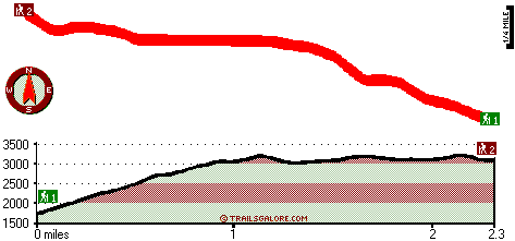
Trailhead 1 to Trailhead 2: Total hiking length = 2.3 miles Total climbing distance = 1.5 miles Difficulty : Medium Casual Hiking Pace:
2.5 hours
Fast Hiking Pace:
1.5 hours
Trailhead 2 to Trailhead 1: Total hiking length = 2.3 miles Total climbing distance = .4 miles Difficulty : Easy Casual Hiking Pace:
1.5 hours
Fast Hiking Pace:
1 hours
| | Trailhead 1 back to Trailhead 1: Total hiking length = 4.6 miles Total climbing distance = 1.9 miles Difficulty : Medium Casual Hiking Pace:
4 hours
Fast Hiking Pace:
2.5 hours
Trailhead 2 back to Trailhead 2: Total hiking length = 4.6 miles Total climbing distance = 1.9 miles Difficulty : Medium Casual Hiking Pace:
4 hours
Fast Hiking Pace:
2.5 hours
|
Total elevation difference: 1607 feet

Best Western Oakridge Inn, Oakridge
|
9 miles away
This Oakridge, Oregon hotel offers a complimentary continental breakfast each morning and convenient access to a variety of outdoor activities. Discover the Best Western Oakridge Inn, nestled agains...
|
| |
Moonstone Village Green Resort, Cottage Grove
|
40 miles away
Village Green Resort is located off Interstate 5, in Cottage Grove. The resort is six miles from the covered bridges, and approximately 30 miles from Eugene Airport. We are less than a mile from two g...
|
|
User input for Johnson Meadows Trail, Central Cascade Range, Lane County, Oregon:

Outdoors Recreation Near Eugene-Springfield, Oregon Very comprehensive list of a variety of outdoors recreation in the vicinity of Eugene-Springfield, Oregon, the metro area neareast to Johnson Meadows Trail. Find info on campgrounds, hiking trails, ski resorts, lakes, beaches, parks, whitewater and more.
More Hotels and Campgrounds Near Johnson Meadows Trail, Central Cascade Range, Lane County, Oregon
| |
| |
 |
|
| These outdoors activities are available near Johnson Meadows Trail. |
| | Trails Near Johnson Meadows Trail:
 |
Grass Mountain Trail, Lane County
County
, 1 miles away, 0.6 hiking miles, 341 feet elevation difference |
 |
Rocky Point Way, Lane County
County
, 2 miles away, 4.4 hiking miles, 2915 feet elevation difference |
 |
Packard Creek Trail, Lane County
County
, 3 miles away, 4.9 hiking miles, 2844 feet elevation difference |
 |
Moon Lake Trail, Lane County
County
, 5 miles away, 3.4 hiking miles, 3357 feet elevation difference |
 |
Dinner Ridge Way, Lane County
County
, 5 miles away, 7.7 hiking miles, 4056 feet elevation difference |
 |
Skeeter Camp Trail, Lane County
County
, 6 miles away, 2.4 hiking miles, 1108 feet elevation difference |
|
| | Whitewater Near Johnson Meadows Trail:
 |
Willamette River - Middle Fork, Lane County
County
, 9 miles away, Class II - 12.5 miles long (Hills Creek Dam to Lookout Point Reservoir) |
 |
Brice Creek, Lane County
County
, 10 miles away, Class IV-V - 4.5 miles long (Parker Falls to Champion Creek) |
 |
Hills Creek, Lane County
County
, 11 miles away, Class IV - 6 miles long (6 mi above Reservoir) |
 |
Salmon Creek, Lane County
County
, 12 miles away, Class II-V - 12 miles long (Top of Upper Salmon Creek Gorge to Oakridge) |
 |
Salt Creek, Lane County
County
, 12 miles away, Class III-IV - 7.2 miles long (McCredie Hot Springs to Rigdon Road Bridge) |
|
| | Hotels Near Johnson Meadows Trail:
 |
Best Western Oakridge Inn, Oakridge
, 9 miles away |
 |
Moonstone Village Green Resort, Cottage Grove
, 40 miles away |
 |
Comfort Inn Cottage Grove, Cottage Grove
, 40 miles away |
 |
Holiday Inn Express Cottage Grove, Or, Cottage Grove
, 40 miles away |
 |
Super 8 Creswell, Creswell
, 40 miles away |
|
|
|
 |
|