| |
|
| | Backcountry hiking in Oregon is such a wonderful thing to do. Alright, enough of spending all this time inside a building, time to get out, and Humbug Ridge Trail in Marion County, Oregon is the outdoors at its best. Here in Oregon trekking is always an exciting thing to do. High temperatures at Humbug Ridge Trail during the long summer days are in the 70's with overnight lows in the 50's. Highs throughout the winter are ordinarily in the 40's with temperatures at Humbug Ridge Trail dipping down into the 30's throughout winter nights. The total elevation |
|
difference for this hiking and backpacking trail is 1,523 feet which is about average. This is a two-ended hiking and backpacking trail with two trailheads which means you have the option of backcountry trekking it one way if you have someone to pick you up at the other end. This
| | is just one of a large number of backcountry trails in this region. The backcountry hiking trails of the Central Cascade Range are a wonderful way to explore these highlands. Every great outdoors hiking trail in Oregon is worth trekking. Being 13.8 miles long; it's a long backpacking and hiking trail. Now this backcountry hiking trail is pretty long, so make sure you bring plenty of supplies. There are great outdoors hiking trails all over Oregon, and one of these is Humbug Ridge Trail in Marion County. Humbug Ridge Trail is not very close to Hood River at | |
|
all, but it is a good hideaway from the settlement. This backcountry hiking trail sometimes gets very dry, so make sure you check current conditions and fire restrictions with local forest authorities before you head out. Please follow all local rules about fires and camping. This
backcountry hiking trail is a very long backcountry hiking trail having an average number of uphill miles which makes it a magnificent backcountry trail for experienced trekkers in good shape. This trek should take you about 2 days, so it's a magnificent thing if your backpack
is big enough to do the job. Humbug Ridge Trail goes through some very different elevations, and that means that some parts of the backpacking and hiking trail could be very different from other parts of it. Humbug Ridge Trail is a wet site that gets a lot of precipitation; of
all the months in a year December is the one with the most rain, and the driest of the months is July.
Briefly about the general area: Everybody loves Round Meadow, and there's some flowing water nearby, Mother Lode Creek is a stream you can have a look at while you're
here. If you have a thing about the outdoors you'll have a thing about it here in the Central Cascade Range. A pleasant location for whitewater paddling right next door to Humbug Ridge Trail is Breitenbush River; why not camp at Detroit Lake State Park while you're here at Humbug
Ridge Trail. Man, is there plenty of cool things to do in the vicinity of Humbug Ridge Trail. Camping is available at B and B Rentals, and a short spree to Terrace Spring is always worthwhile. Battle Creek is a stream that you may bump into while here, and in the event that
you don’t have a problem getting wet, you can always go whitewater paddling on Collawash River. This is such a fun river. A spree to Humbug Ridge Trail wouldn't be complete without taking a look at Maryanne Spring, and Pansy Basin is a great spot. This location, the Central Cascade Range, has so much outdoors entertaining things.
|
|
Location of Trailhead 1: Latitude 44.8178, Longitude -122.0866 - - Directions and Road Map
Location of Trailhead 2: Latitude 44.8298, Longitude -121.9878 - - Directions and Road Map

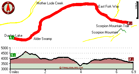
Trailhead 1 to Trailhead 2: Total hiking length = 6.9 miles Total climbing distance = 2.8 miles Difficulty : Difficult Casual Hiking Pace:
6 hours
Fast Hiking Pace:
3.5 hours
Trailhead 2 to Trailhead 1: Total hiking length = 6.9 miles Total climbing distance = 3.2 miles Difficulty : Difficult Casual Hiking Pace:
6.5 hours
Fast Hiking Pace:
3.5 hours
| | Trailhead 1 back to Trailhead 1: Total hiking length = 13.8 miles Total climbing distance = 6 miles Difficulty : Difficult Casual Hiking Pace:
2 days
Fast Hiking Pace:
8 hours
Trailhead 2 back to Trailhead 2: Total hiking length = 13.8 miles Total climbing distance = 6 miles Difficulty : Difficult Casual Hiking Pace:
2 days
Fast Hiking Pace:
8 hours
|
Total elevation difference: 1523 feet

|
| |
Whispering Woods (Vri), Welches
|
25 miles away
Whispering Woods is a resort destination east of Portland which opened in 1981 with 42 condominiums. The second phase of 24 additional condominiums opened in 1992. The resort offers a clubhouse with a...
|
|
User input for Humbug Ridge Trail, Central Cascade Range, Marion County, Oregon:

Outdoors Recreation Near Hood River, Oregon Very comprehensive list of a variety of outdoors recreation in the vicinity of Hood River, Oregon, the metro area neareast to Humbug Ridge Trail. Find info on campgrounds, hiking trails, ski resorts, lakes, beaches, parks, whitewater and more.
More Hotels and Campgrounds Near Humbug Ridge Trail, Central Cascade Range, Marion County, Oregon
| |
| |
 |
|
| These outdoors activities are available near Humbug Ridge Trail. |
| | Trails Near Humbug Ridge Trail:
 |
Fox Creek Trail, Marion County
County
, 1 miles away, 7.2 hiking miles, 1917 feet elevation difference |
 |
Elk Lake Trail, Marion County
County
, 2 miles away, 8.5 hiking miles, 1845 feet elevation difference |
 |
Janus Butte Trail, Marion County
County
, 3 miles away, 8.2 hiking miles, 2376 feet elevation difference |
 |
Scorpion Ridge Trail, Marion County
County
, 3 miles away, 7.6 hiking miles, 2625 feet elevation difference |
 |
East Fork Way, Marion County
County
, 3 miles away, 2.1 hiking miles, 913 feet elevation difference |
 |
Welcome Lakes Trail, Marion County
County
, 3 miles away, 8.1 hiking miles, 3795 feet elevation difference |
 |
Scorpion Mountain Trail, Marion County
County
, 4 miles away, 0.5 hiking miles, 176 feet elevation difference |
|
| | Whitewater Near Humbug Ridge Trail:
 |
Breitenbush River, Marion County
County
, 4 miles away, Class IV - 8.2 miles long (Cleator Bend Campground to Detroit Lake) |
 |
Collawash River, Marion County
County
, 5 miles away, Class III-IV(V) - 5 miles long (Elk Lake Creek to river mile 5.5) |
 |
Santiam River - North, Marion/ Linn County
County
, 7 miles away, Class III-IV - 7.3 miles long (Bruno Mt. Road Bridge to Detroit Reservoir) |
 |
Collawash River, Marion County
County
, 8 miles away, Class IV - 5.5 miles long (Mile 5.5 bridge to Two Rivers Picnic Area) |
 |
Clackamas River, Clackamas County
County
, 10 miles away, Class III-IV - 8 miles long (June Creek Br. to Collawash River) |
|
| | Hotels Near Humbug Ridge Trail:
 |
Detroit Motel, Detroit
, 9 miles away |
 |
All Season's Motel, Detroit
, 11 miles away |
 |
Lakeside Motel, Detroit
, 11 miles away |
 |
The Resort At The Mountain, Welches
, 25 miles away |
 |
Old Welches Inn, Welches
, 25 miles away |
|
|
|
 |
|