Oregon hiking trails - Horseshoe Ridge Trail, Central Cascade Range, Clackamas County

   
  Horseshoe Ridge Trail is positioned a rather lengthy trip from Hood River, but backpacking it is magnificent excitement any time. Good hiking trails in Oregon are in abundance, and Horseshoe Ridge Trail in Clackamas County is one of them. Time to get out, and breathe some fresh air, and Horseshoe Ridge Trail in Clackamas County, Oregon is a really magnificent place to spend some time. The length of this wilderness hiking trail is about average with an average amount of climbing distance which makes this a very tough wilderness trail for advanced backcountry
    hikers looking for a nice challenge. Different parts of this great outdoors trail are at very different elevations, so keep in mind that you may need to dress differently at different elevations. Horseshoe Ridge Trail sees pretty high levels of rain; the wettest month of the year
is regularly December, that's the one that rains the most, and July on the other hand is the driest. This backcountry trek shouldn't take more than 5.5 hours, but you never know stuff could go wrong and you could get stuck so be prepared for that. Oregon has so much to offer the wilderness lovers. When you're here in Oregon backcountry trekking along one of its hiking trails is a nice way to spend some time. Every single Oregon hiking trail has its own unique splendor. Don’t forget to check for any current restrictions or closures before you go. This is  
a long trail, so do pack enough food to last the whole trip. There is only one trailhead, so you'll be hiking it in and back out. Being 6.6 miles long it's an average length great outdoors trail. Hiking here in the Central Cascade Range is a very great way to see these peaks. This is one of many wilderness trails in the surrounding area. Horseshoe Ridge Trail has a total elevation difference of 2,174 feet which is an average number. The warmest time of the year brings highs in the 70's to Horseshoe Ridge Trail. Once the sun is down it plunges down to the 50's. The cold days of the winter come with highs in the 40's while Horseshoe Ridge Trail overnight low temperatures throughout the winter are in the 30's.

Briefly about the general area:
This river is a wonderful place to visit. Get your heart pumping on the wonderful whitewater of Zigzag River; Old Maid Flat is a pleasant place to stretch your legs a bit. Now, you may assume that's a lot but there's even more amusing stuff to do here at Horseshoe Ridge Trail. Horseshoe Ridge Trail is a great site to camp, Pioneer Tollgate Campground is a great site.
While staying at Horseshoe Ridge Trail you could always explore Devil Canyon, and it's a wonderful idea to stop by Short Creek. Be careful coming to the Central Cascade Range, you might not ever want to go back home again. Camping at Horseshoe Ridge Trail is delightful fun, Devils Meadow Campground is a delightful local campground; folks from Hood River love to come here. Whitewater paddling is not for everyone but if it's for you then we recommend Sandy River, and while you're here, you could take a look at Cast Creek.

Location of Trailhead: Latitude 45.3704, Longitude -121.869
- - Directions and Road Map

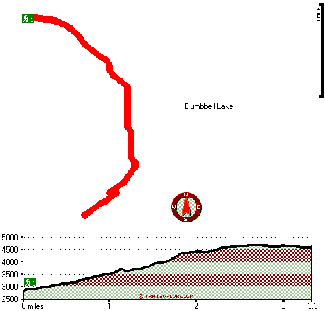
Total in and out hiking length = 6.6 miles

Total climbing distance = 2.5 miles

Difficulty : Difficult

Casual Hiking Pace: 5.5 hours

Fast Hiking Pace: 3.5 hours

Total elevation difference: 2174 feet


Falcon's Crest Inn On Mt. Hood, Government Camp
7 miles away
  
Mount Hood Inn, Government Camp
7 miles away
At the Mount Hood Inn we offer our guests the finest accommodations on the mountain. With our modern facilities and friendly local staff we are able to give you the attention and service you have com...
User input for Horseshoe Ridge Trail, Central Cascade Range, Clackamas County, Oregon:

Submit Input:
Your Name:
Write or Paste Input here:

Upload picture:      Review Guidelines


Outdoors Recreation Near Hood River, Oregon
Very comprehensive list of a variety of outdoors recreation in the vicinity of Hood River, Oregon, the metro area neareast to Horseshoe Ridge Trail. Find info on campgrounds, hiking trails, ski resorts, lakes, beaches, parks, whitewater and more.

Current weather conditions at Horseshoe Ridge Trail, Central Cascade Range, Clackamas County, Oregon
WXPort

Local climate location: HEADWORKS PTLD WTR BUR 16 miles away

The Resort At The Mountain, Welches
7 miles away

Whispering Woods Resort, Welches
7 miles away
Nestled in the heart of the Columbia River Valley, where elements of the natural world will touch your spirit of discovery, Whispering Woods Resort lies surrounded by the beauty of Mount Hood National...

More Hotels and Campgrounds Near Horseshoe Ridge Trail, Central Cascade Range, Clackamas County, Oregon

OTHER_INFO
  Central Cascade Range Campgrounds
Complete list of all the campgrounds in the Central Cascade Range.

Central Cascade Range Outdoors Info
Complete outdoors info for the Central Cascade Range.

Oregon Hiking Trails
Complete list of all hiking trails in Oregon

Books about hiking trails in Oregon
List of books available on Amazon.com about hiking trails in Oregon.

Oregon Outdoors Index
This is a very comprehensive index of outdoors activities in the great state of Oregon.


TOPO
High quality water resistant topo map of Horseshoe Ridge Trail, Central Cascade Range, Clackamas County, Oregon.

OUTDOORS_GUIDE
These outdoors activities are available near Horseshoe Ridge Trail.
 Trails Near Horseshoe Ridge Trail:
Cast Creek Trail, Clackamas County County , 1 miles away, 4 hiking miles, 2784 feet elevation difference
Devils Canyon Trail, Clackamas County County , 2 miles away, 5.5 hiking miles, 1797 feet elevation difference
West Zigzag Mountain Trail, Clackamas County County , 3 miles away, 6.4 hiking miles, 3016 feet elevation difference
Burnt Lake Trail, Clackamas County County , 3 miles away, 5 hiking miles, 2553 feet elevation difference
Still Creek Trail, Clackamas County County , 3 miles away, 1.6 hiking miles, 274 feet elevation difference
Flag Mountain Trail, Clackamas County County , 3 miles away, 1.6 hiking miles, 924 feet elevation difference
Cool Creek Trail, Clackamas County County , 4 miles away, 4.3 hiking miles, 3377 feet elevation difference
 Camp Grounds Near Horseshoe Ridge Trail:
Devils Meadow Campground, Clackamas County, 2 miles away
Pioneer Tollgate Campground, Clackamas County, 4 miles away
Twin Bridges Campground, Clackamas County, 4 miles away
Barlow Campground, Clackamas County, 4 miles away
Kinzel Lake Campground, Clackamas County, 5 miles away
 Whitewater Near Horseshoe Ridge Trail:
Sandy River, Clackamas County County , 3 miles away, Class IV - 4.5 miles long (McNeil Campground to Lolo Pass Road)
Zigzag River, Clackamas County County , 5 miles away, Class III-IV - 3.2 miles long (Tollgate to Sandy River)
Sandy River, Clackamas County County , 12 miles away, Class II-III - 13.5 miles long (Lolo Pass Road to Marmot Dam)
Hood River - Lake Branch, Hood River County County , 12 miles away, Class IV-V - 3 miles long (3 miles above West Fork to Confluence with West Fork)
Little Sandy River, Clackamas County County , 14 miles away, Class -blank- - 10 miles long (Bridge on FS 14 to SE Marmot Road)
 National Parks Near Horseshoe Ridge Trail:
Mount Rainier National Park, Ashford - WA , 68 miles away
 Hotels Near Horseshoe Ridge Trail:
Snowline Motel, Rhododendron , 4 miles away
Falcon's Crest Inn On Mt. Hood, Government Camp , 7 miles away
Mt Hood Inn, Government Camp , 7 miles away
Mount Hood Inn, Government Camp , 7 miles away
Thunderhead Lodge, Government Camp , 7 miles away
 Lakes Near Horseshoe Ridge Trail
Dumbbell Lake, Clackamas County , 1 miles away
Cast Lake, Clackamas County , 2 miles away

Outdoors related information copyright © Stratus-Pikpuk, Inc. - Detailed hotel information copyright © Interactive Hotel Solutions