Oregon hiking trails - High Trail, Wallowa Mountains, Wallowa County

   
  In Oregon you never run out of outdoors fun. Oregon has plenty of brilliant trails, and one of these is High Trail in Wallowa County. There are plenty of trails in Oregon; each one of them is different from the others. Hey, time for a hike don’t you think? High Trail in Wallowa County, Oregon is the outdoors at its best. The total elevation difference for High Trail is 3,735 feet, and that is higher than average. For the period of the summertime months highs here at High Trail get into the 90's, and the overnight is rather chillier of course, mostly in
    the 50's. The winter brings highs down to the 40's, and winter nights come with lows in the 20's to High Trail. When you're here in Oregon backcountry backpacking along one of its trails is the brilliant thing to do. And keep in mind that there could be temporary safety restrictions
in site. Backcountry hiking here in the Wallowa Mountains is an outstanding way to explore these peaks. This backcountry hiking trail goes through some very different elevations, and that means that some parts of the backcountry hiking trail could be very different from other parts of it. There is only one trailhead, so you're looking at an in and out backcountry trek. This is a backpacking trail that is quite long, so do pack enough food to last the whole trip. High Trail gets very little rainfall; the month with most of the rain is May; July meanwhile is  
the driest month. This vicinity does get very dry sometimes, so do check for current fire restrictions before you go if you plan to bring a stove or make a camp fire. High Trail is a backpacking and hiking trail quite far from Lewiston, but it is a really fine backpacking and hiking trail. This is one of a very small number of backpacking trails in this vicinity. High Trail is a very long backcountry trail having an average number of uphill miles which makes it a tremendous backpacking trail for experienced trekkers in nice shape. High Trail is 18.2 miles long; it's longer than many backcountry hiking trails. This backcountry hike should take you about 2.5 days, so make sure you've got all your overnight gear packed.

Briefly about the general area:
Near High Trail you come across wonderful sites like Sluice Creek Saddle. You'll need more than a day to look at everything High Trail has to offer, you can camp at Seven Devils Campground. Not enough hours in a day to enjoy this location. There are some magnificent whitewater spots on Snake River. There's so much to do here at High Trail that you need to camp here for a while, Windy Saddle Campground is a nice site for that.
Some of the water nearby flows, like Rattlesnake Creek; there's whitewater on Snake River for all you thrill seekers. You just can't picture the amount of outdoors fun things the Wallowa Mountains has to offer. Rough Creek is a fine local stream. Whohoo, so many exciting things in one place! The Wallowa Mountains is so good! A pleasant place like Sour Apple Flat here at High Trail is too wonderful to miss, and a spree to Sacajawea Spring will fill your soul with tremendous feelings.
Dry Basin is a splendid site here at High Trail; do put some time aside to spend at Waterspout Rapids since you're here at High Trail.

Location of Trailhead: Latitude 45.4367, Longitude -116.6632
- - Directions and Road Map

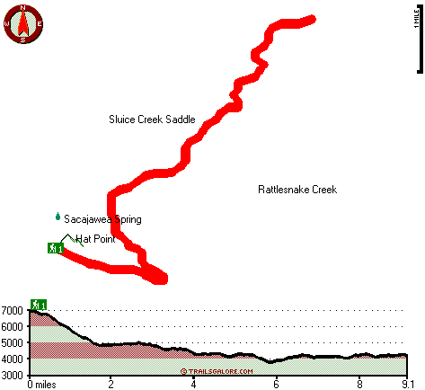
Total in and out hiking length = 18.2 miles

Total climbing distance = 7.8 miles

Difficulty : Difficult

Casual Hiking Pace: 2.5 days

Fast Hiking Pace: 2 days

Total elevation difference: 3735 feet


Best Western Salmon Rapids Lodge, Riggins
22 miles away
Overlooking the famous Salmon River, the Little Salmon River, and their majestic canyons, Best Western Salmon Rapids Lodge welcomes you with comfortable lodge-style furnishings, outstanding amenities,...
  
Best Western Rama Inn & Suites, Enterprise
45 miles away
This full-service Enterprise, Oregon hotel is minutes away from local attractions and is an ideal weekend getaway from busy everyday life. Enjoy a peaceful and relaxing getaway to Northwestern Orego...
User input for High Trail, Wallowa Mountains, Wallowa County, Oregon:

Submit Input:
Your Name:
Write or Paste Input here:

Upload picture:      Review Guidelines


Outdoors Recreation Near Lewiston, Idaho-Washington
Very comprehensive list of a variety of outdoors recreation in the vicinity of Lewiston, Idaho-Washington, the metro area neareast to High Trail. Find info on campgrounds, hiking trails, ski resorts, lakes, beaches, parks, whitewater and more.

Current weather conditions at High Trail, Wallowa Mountains, Wallowa County, Oregon
WXPort

Local climate location: RIGGINS 32 miles away

Western Mountain Lodge, Mccall
46 miles away
**Welcome to The Western Mountain Lodge. We look forward to pampering you with the best in service and hospitality in the West. We offer comfort and affordability with all the amenities you need f...

AmericInn McCall, Mccall
46 miles away
Welcome to the end of the day. The newest addition to the lodging choices in McCall Idaho is the AmericInn Lodge and Suites. Centrally located near downtown shopping, airport access, and the many year...

More Hotels and Campgrounds Near High Trail, Wallowa Mountains, Wallowa County, Oregon

OTHER_INFO
  Wallowa Mountains Campgrounds
Complete list of all the campgrounds in the Wallowa Mountains.

Wallowa Mountains Outdoors Info
Complete outdoors info for the Wallowa Mountains.

Oregon Hiking Trails
Complete list of all hiking trails in Oregon

Books about hiking trails in Oregon
List of books available on Amazon.com about hiking trails in Oregon.

Oregon Outdoors Index
This is a very comprehensive index of outdoors activities in the great state of Oregon.


TOPO
High quality water resistant topo map of High Trail, Wallowa Mountains, Wallowa County, Oregon.

OUTDOORS_GUIDE
These outdoors activities are available near High Trail.
 Trails Near High Trail:
Western Rim National Recreation Trail, Wallowa County County , 8 miles away,  7.4 hiking miles, 1434 feet elevation difference
Summit Creek Trail, Wallowa County County , 13 miles away, 4.7 hiking miles, 3050 feet elevation difference
 Camp Grounds Near High Trail:
Seven Devils Campground, Idaho County, 10 miles away
Windy Saddle Campground, Idaho County, 10 miles away
Black Lake Campground, Adams County, 14 miles away
Vermillion Bar Campground, Wallowa County, 16 miles away
Dove Creek Campground, Wallowa County, 17 miles away
 Whitewater Near High Trail:
Snake River, Wallowa County County , 4 miles away, Class III-IV - 32 miles long (Hells Canyon Dam to Pittsburg Landing)
Snake River, Wallowa County County , 14 miles away, Class II-IV - 71.5 miles long (Hells Canyon Dam to Washington Border)
Salmon River, Idaho County County , 18 miles away, Class II-IV - 50 miles long (White Bird to Snake River confluence)
Imnaha River, Wallowa County County , 19 miles away, Class III-IV - -blank- miles long (to Snake Lake)
Little Salmon River, Idaho/ Adams County County , 24 miles away, Class II-V - 20 miles long (Hazard Creek to Salmon River at Riggins)
 Hotels Near High Trail:
Best Western Salmon Rapids Lodge, Riggins , 22 miles away
Best Western Rama Inn & Suites, Enterprise , 45 miles away
Western Mountain Lodge, Mccall , 46 miles away
AmericInn McCall, Mccall , 46 miles away
Mccall Super 8 Lodge, Mccall , 46 miles away
 Lakes Near High Trail
Lily Pad Lake, Idaho County , 7 miles away
Basin Lake, Idaho County , 8 miles away

Outdoors related information copyright © Stratus-Pikpuk, Inc. - Detailed hotel information copyright © Interactive Hotel Solutions