Oregon hiking trails - Happy Prairie Way, Central Cascade Range, Douglas County

   
  No chance of getting bored in Oregon if you like the wilderness. If you happen to be in Oregon, why not go backcountry hiking, it is something that is always fun to do. There are many splendid backcountry trails in Oregon, and one of those is Happy Prairie Way in Douglas County. The total elevation difference for Happy Prairie Way is 2,706 feet which is a higher than average number. For the period of the summer months at Happy Prairie Way highs are ordinarily in the 80's, and throughout the night it cools down to the 40's. For the period of the wintertime
    this spot gets highs in the 40's; after the sun is down throughout the wintertime temperatures at Happy Prairie Way fall into the 20's. This region does get very dry sometimes, so make sure you check current conditions and fire restrictions with local forest authorities before
you head out. Happy Prairie Way is a wet spot that gets a great deal of precipitation; December is the wettest month with most rain, and July meanwhile is the driest month. Happy Prairie Way goes through some very different elevations, so keep in mind that you may need to dress differently at different elevations. This walk shouldn't take more than 5 hours, but of course some folks walk a bit slower and some a bit faster. Happy Prairie Way is not that long but you should still bring some emergency supplies just in case something happens. Don’t forget  
to check for any current restrictions or closures before you go. Because Happy Prairie Way is very isolated from modern life, when you backcountry trek it you're always having a great time. When was the last time you got out in the great outdoors a bit? Happy Prairie Way in Douglas County, Oregon is just the place. Happy Prairie Way is a mid-length trail with an average amount of climbing distance which makes this backcountry hiking trail nice for the average backcountry trekker looking for a cool adventure. Being 5.8 miles long it's an average length hiking trail. Every single Oregon backcountry trail is different from the others. The beautiful trails of the Central Cascade Range are a really wonderful way to spend quality time in the wilderness. This is one of many backcountry hiking trails in the surrounding area. Happy Prairie Way has two trailheads which means you have the option of backcountry backpacking it one way if you have someone to pick you up at the other end.

Briefly about the general area:
This site, the Central Cascade Range, has so much outdoors exciting stuff. Chuckle Springs is a scenic spot to pop by while you're at Happy Prairie Way. You'll need more than a day to explore everything Happy Prairie Way has to offer, you can camp at Diamond Lake RV Park. Tumblebug Creek is a scenic stream that is worth checking out, and Happy Prairie Way is a fine site to visit for more than one day, Camas Creek Campground is a fine site to camp nearby.
Don't forget to take a great little journey to Royal Creek, and float down the rapids of Hills Creek in a kayak. Happy Prairie is right here at Happy Prairie Way; a short spree to Indigo Springs is always worthwhile. So many amusing things to do at Happy Prairie Way, so little time. A good place to stop at right next door to Happy Prairie Way is Paddys Valley.

Location of Trailhead 1: Latitude 43.4561, Longitude -122.2394
- - Directions and Road Map

Location of Trailhead 2: Latitude 43.4837, Longitude -122.2494
- - Directions and Road Map


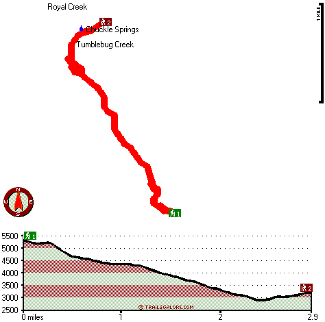
Trailhead 1 to Trailhead 2:
Total hiking length = 2.9 miles
Total climbing distance = .4 miles
Difficulty : Easy
Casual Hiking Pace: 2 hours
Fast Hiking Pace: 1 hours

Trailhead 2 to Trailhead 1:
Total hiking length = 2.9 miles
Total climbing distance = 2 miles
Difficulty : Difficult
Casual Hiking Pace: 3 hours
Fast Hiking Pace: 1.5 hours
    Trailhead 1 back to Trailhead 1:
Total hiking length = 5.8 miles
Total climbing distance = 2.4 miles
Difficulty : Medium
Casual Hiking Pace: 5 hours
Fast Hiking Pace: 3.5 hours

Trailhead 2 back to Trailhead 2:
Total hiking length = 5.8 miles
Total climbing distance = 2.4 miles
Difficulty : Medium
Casual Hiking Pace: 5 hours
Fast Hiking Pace: 3.5 hours

Total elevation difference: 2706 feet


Best Western Oakridge Inn, Oakridge
22 miles away
This Oakridge, Oregon hotel offers a complimentary continental breakfast each morning and convenient access to a variety of outdoor activities. Discover the Best Western Oakridge Inn, nestled agains...
  
User input for Happy Prairie Way, Central Cascade Range, Douglas County, Oregon:

Submit Input:
Your Name:
Write or Paste Input here:

Upload picture:      Review Guidelines


Outdoors Recreation Near Klamath Falls, Oregon
Very comprehensive list of a variety of outdoors recreation in the vicinity of Klamath Falls, Oregon, the metro area neareast to Happy Prairie Way. Find info on campgrounds, hiking trails, ski resorts, lakes, beaches, parks, whitewater and more.

Current weather conditions at Happy Prairie Way, Central Cascade Range, Douglas County, Oregon
WXPort

Local climate location: OAKRIDGE FISH HATCHERY 1 miles away


More Hotels and Campgrounds Near Happy Prairie Way, Central Cascade Range, Douglas County, Oregon

OTHER_INFO
  Central Cascade Range Campgrounds
Complete list of all the campgrounds in the Central Cascade Range.

Central Cascade Range Outdoors Info
Complete outdoors info for the Central Cascade Range.

Oregon Hiking Trails
Complete list of all hiking trails in Oregon

Books about hiking trails in Oregon
List of books available on Amazon.com about hiking trails in Oregon.

Oregon Outdoors Index
This is a very comprehensive index of outdoors activities in the great state of Oregon.


TOPO
High quality water resistant topo map of Happy Prairie Way, Central Cascade Range, Douglas County, Oregon.

OUTDOORS_GUIDE
These outdoors activities are available near Happy Prairie Way.
 Trails Near Happy Prairie Way:
McGowan Mountain Way, Douglas County County , 2 miles away, 2.9 hiking miles, 2074 feet elevation difference
Bear Mountain Trail, Lane County County , 3 miles away, 2.8 hiking miles, 2998 feet elevation difference
Swift Creek Trail, Lane County County , 4 miles away, 5.8 hiking miles, 2139 feet elevation difference
Juniper Trail, Lane County County , 5 miles away, 5.9 hiking miles, 558 feet elevation difference
Diamond Peak Trail, Lane County County , 5 miles away, 5.2 hiking miles, 1462 feet elevation difference
 Camp Grounds Near Happy Prairie Way:
Camas Creek Campground, Douglas County, 18 miles away
Diamond Lake RV Park, Chemult, 19 miles away
Shelter Cove Resort, Crescent Lake, 19 miles away
Lake Lucile Campground, Douglas County, 19 miles away
Oakridge RV Park, Oakridge, 20 miles away
 Whitewater Near Happy Prairie Way:
Hills Creek, Lane County County , 12 miles away, Class IV - 6 miles long (6 mi above Reservoir)
 National Parks Near Happy Prairie Way:
Crater Lake National Park, Crater Lake - OR , 30 miles away
 Hotels Near Happy Prairie Way:
Best Western Oakridge Inn, Oakridge , 22 miles away

Outdoors related information copyright © Stratus-Pikpuk, Inc. - Detailed hotel information copyright © Interactive Hotel Solutions