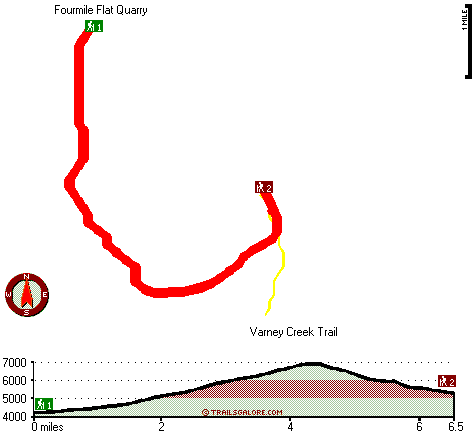
Oregon hiking trails - Greylock Mountain Trail, Southern Cascade Range, Klamath County

   
  Every single Oregon great outdoors hiking trail is lovely in its own way. Oregon has plenty of pleasant great outdoors hiking trails; Greylock Mountain Trail in Klamath County is one of them. Gotta get out of the town man, and Greylock Mountain Trail in Klamath County, Oregon is an excellent place to go. This is a two-ended backpacking and hiking trail with two trailheads, so if you can get a ride from someone, you can backcountry hike it just one way. This wilderness hiking trail goes through some very different elevations, and that means that some
    parts of the wilderness hiking trail could be very different from other parts of it. Greylock Mountain Trail has a total elevation difference of 3,383 feet which is higher than average. Being 13 miles long; it's considered a longer backcountry hike. At parts of the year this neighborhood
sees very little rain, so do check for current fire restrictions before you go if you plan to bring a stove or make a camp fire. Greylock Mountain Trail is a wet place that gets much rainfall; December is the month that gets the most snow, and July is when it's the driest. Trekking in Oregon is something that is always fun to do. This great outdoors trail is many miles long with an average amount of climbing distance which makes this hiking trail splendid for hard core backpackers looking for adventure. A long tour parts Klamath Falls from Greylock Mountain  
Trail, but great outdoors trails like these are perfect. For the duration of the summertime months, highs ordinarily are in the 60's at Greylock Mountain Trail, and through summer nights temperatures are in the 40's. The wintertime brings highs down to the 30's, and after the sun is down through the wintertime temperatures at Greylock Mountain Trail fall into the 10's. This is a long hiking trail, so don't forget to pack enough supplies. In Oregon you never run out of outdoors fun. Don’t forget to check for any current restrictions or closures before you go. This is an area covered with lots of hiking trails. The great outdoors trails of the Southern Cascade Range are a really good way to spend quality time in nature. This walk should take you about 2 days, so make sure you've got all your overnight gear packed.

Briefly about the general area:
Yeah, come up here to the Southern Cascade Range for a great time. A tour to Greylock Mountain Trail wouldn't be complete without taking a look at Odessa Spring, and a magnificent place to stop by is South Pass. Point Comfort is not far from Greylock Mountain Trail at all, and why not a little side tour to Varney Creek.
Seldom Creek is a great local stream, and a brilliant place to camp here at Greylock Mountain Trail is White Pine Campground. Camping is available at Hemlock Lake Campground, and a perfect spot like Fourmile Flat Quarry here at Greylock Mountain Trail is too good to miss. Be careful coming to the Southern Cascade Range, you might not ever wanna go back home again.
But wait, there's more to do near Greylock Mountain Trail. Klamath River is a good whitewater spot next to Greylock Mountain Trail; a short journey to Harriman Spring is always worthwhile.

Location of Trailhead 1: Latitude 42.4314, Longitude -122.1456
- - Directions and Road Map

Location of Trailhead 2: Latitude 42.4, Longitude -122.1126
- - Directions and Road Map


Trailhead 1 to Trailhead 2:
Total hiking length = 6.5 miles
Total climbing distance = 3.9 miles
Difficulty : Difficult
Casual Hiking Pace: 6.5 hours
Fast Hiking Pace: 3.5 hours

Trailhead 2 to Trailhead 1:
Total hiking length = 6.5 miles
Total climbing distance = 1.9 miles
Difficulty : Difficult
Casual Hiking Pace: 5 hours
Fast Hiking Pace: 3 hours
    Trailhead 1 back to Trailhead 1:
Total hiking length = 13 miles
Total climbing distance = 5.8 miles
Difficulty : Difficult
Casual Hiking Pace: 2 days
Fast Hiking Pace: 7.5 hours

Trailhead 2 back to Trailhead 2:
Total hiking length = 13 miles
Total climbing distance = 5.8 miles
Difficulty : Difficult
Casual Hiking Pace: 2 days
Fast Hiking Pace: 7.5 hours

Total elevation difference: 3383 feet


Americas Best Value Inn, Klamath Falls
24 miles away
Welcome to the Americas Best Value Inn of gorgeous Klamath Falls, Newly renovations, See our new room with Big TV DVD and VCR. Located just off Highway 97 and 140 approximately one miles from O.I.T. A...
  
Klamath Falls Super 8 Motel, Klamath Falls
24 miles away
AAA approved. Conveniently located on Hwy 97, near Hwy 140, and Hwy 66. Downtown just minutes away. Klamath Medical Center Oregon Institute of Technology, State and National Forestry offices nearby. L...
User input for Greylock Mountain Trail, Southern Cascade Range, Klamath County, Oregon:

Submit Input:
Your Name:
Write or Paste Input here:

Upload picture:      Review Guidelines


Outdoors Recreation Near Klamath Falls, Oregon
Very comprehensive list of a variety of outdoors recreation in the vicinity of Klamath Falls, Oregon, the metro area neareast to Greylock Mountain Trail. Find info on campgrounds, hiking trails, ski resorts, lakes, beaches, parks, whitewater and more.

Current weather conditions at Greylock Mountain Trail, Southern Cascade Range, Klamath County, Oregon
WXPort

Local climate location: CRATER LAKE NPS HDQTRS 7 miles away

Quality Inn Klamath Falls, Klamath Falls
25 miles away
Walking distance to downtown shops, nature trail, Favell Museum, Baldwin Museum, Veterans Park and Lake Ewanna. FREE high speed internet access available in some rooms. Pet accommodation: 10.00/night,...

Econo Lodge Klamath Falls, Klamath Falls
25 miles away
Please don not request rollaway....

More Hotels and Campgrounds Near Greylock Mountain Trail, Southern Cascade Range, Klamath County, Oregon

OTHER_INFO
  Southern Cascade Range Campgrounds
Complete list of all the campgrounds in the Southern Cascade Range.

Southern Cascade Range Outdoors Info
Complete outdoors info for the Southern Cascade Range.

Oregon Hiking Trails
Complete list of all hiking trails in Oregon

Books about hiking trails in Oregon
List of books available on Amazon.com about hiking trails in Oregon.

Oregon Outdoors Index
This is a very comprehensive index of outdoors activities in the great state of Oregon.


TOPO
High quality water resistant topo map of Greylock Mountain Trail, Southern Cascade Range, Klamath County, Oregon.

OUTDOORS_GUIDE
These outdoors activities are available near Greylock Mountain Trail.
 Trails Near Greylock Mountain Trail:
Varney Creek Trail, Klamath County County , 2 miles away,  8.2 hiking miles, 1592 feet elevation difference
Mountain Lakes Trail, Klamath County County , 2 miles away,  17.2 hiking miles, 2862 feet elevation difference
Moss Creek Trail, Klamath County County , 5 miles away,  7.6 hiking miles, 1926 feet elevation difference
Pelican Butte Trail, Klamath County County , 5 miles away, 10.4 hiking miles, 3325 feet elevation difference
Rocky Point Trail, Klamath County County , 5 miles away,  3.2 hiking miles, 2163 feet elevation difference
South Pass Lake Trail, Klamath County County , 6 miles away,  7.4 hiking miles, 3151 feet elevation difference
Lost Peak Trail, Klamath County County , 7 miles away,  6.8 hiking miles, 1319 feet elevation difference
 Camp Grounds Near Greylock Mountain Trail:
White Pine Campground, Klamath County, 6 miles away
Hemlock Lake Campground, Klamath County, 13 miles away
Saddle Campground, Jackson County, 13 miles away
Lake Of The woods Resort, Klamath Falls, 15 miles away
Sevenmile Marsh Campground, Klamath County, 15 miles away
 Whitewater Near Greylock Mountain Trail:
Klamath River, Klamath County County , 16 miles away, Class IV+ - 5 miles long (JC Boyle Dam to Powerhouse)
Klamath River, Klamath County County , 17 miles away, Class III - 5.5 miles long (Keno Dam to JC Boyle Reservoir)
Trask River, Klamath County County , 19 miles away, Class IV-V - 15 miles long (John Boyle Power Plant to Copco Lake)
Klamath River, Klamath County County , 19 miles away, Class III-IV+ - 17 miles long (JC Boyle Powerhouse to Copco Reservoir)
Jenny Creek, Jackson / Siskiyou County County , 25 miles away, Class IV-V+ - 14 miles long (Ashland Oregon to Iron Gate Reservoir California)
 National Parks Near Greylock Mountain Trail:
Crater Lake National Park, Crater Lake - OR , 25 miles away
Lava Beds National Monument, Tulelake - CA , 51 miles away
 Hotels Near Greylock Mountain Trail:
Americas Best Value Inn, Klamath Falls , 24 miles away
Klamath Falls Super 8 Motel, Klamath Falls , 24 miles away
Quality Inn Klamath Falls, Klamath Falls , 25 miles away
Econo Lodge Klamath Falls, Klamath Falls , 25 miles away
Maverick Motel, Klamath Falls , 26 miles away
 Lakes Near Greylock Mountain Trail
Storm Lake, Klamath County , 2 miles away
Eb Lake, Klamath County , 3 miles away

Outdoors related information copyright © Stratus-Pikpuk, Inc. - Detailed hotel information copyright © Interactive Hotel Solutions