| |
This backpacking and hiking trail has a total elevation difference of 2,109 feet which is about average. Now, this is roughly a 3-day backcountry walk, so it's a magnificent thing if your backpack is big enough to do the job. With its 20.4 miles of walking distance; it's longer than many backcountry trails. At parts of the year this vicinity sees very little rain, so don’t forget to check for any current fire restrictions before you go. Some parts of this backcountry trail are much higher up than other parts of the backcountry trail which of course means you need to be prepared for different conditions on different parts of the backcountry trail. This is a two-ended backpacking and hiking trail with two trailheads, so hiking it one way is an option if you can arrange for a ride back. This is a hiking and backpacking trail that is quite long, so do pack enough food to last the whole trip.
|
Trailhead 1 to Trailhead 2:
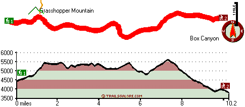
Total hiking length = 10.2 miles
Total climbing distance = 4.2 miles
Difficulty : Difficult
Casual Hiking Pace:
9 hours
Fast Hiking Pace:
5 hours
Trailhead 2 to Trailhead 1:
Total hiking length = 10.2 miles
Total climbing distance = 5 miles
Difficulty : Difficult
Casual Hiking Pace:
1.5 days
Fast Hiking Pace:
5.5 hours
| | Trailhead 1 back to Trailhead 1:
Total hiking length = 20.4 miles
Total climbing distance = 9.2 miles
Difficulty : Difficult
Casual Hiking Pace:
3 days
Fast Hiking Pace:
2 days
Trailhead 2 back to Trailhead 2:
Total hiking length = 20.4 miles
Total climbing distance = 9.2 miles
Difficulty : Difficult
Casual Hiking Pace:
3 days
Fast Hiking Pace:
2 days
|
Total elevation difference: 2109 feet
|


