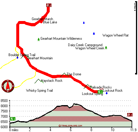
Oregon hiking trails - Gearhart Trail, Southern Cascade Range, Klamath County

   
  Outdoors people generally like this part of Oregon. Gearhart Trail is pretty distant from the closest town, and it is a really perfect wilderness hiking trail. Finally, backcountry backpacking time is here again, and Gearhart Trail in Klamath County, Oregon is just what you need. Gearhart Trail is 23.8 miles long; it's longer than many hiking and backpacking trails. Hiking and backpacking trails for backcountry hiking, and backpacking can be found all over Oregon, and Gearhart Trail in Klamath County is one of them. There are not too many wilderness trails
    in this region. Backcountry trekking in Oregon is something that is always fun to do. Every single Oregon backpacking trail has its own unique splendor. This backpacking trail has a total elevation difference of 2,196 feet which is an average number. Different parts of this hiking
and backpacking trail are at very different elevations, and that means that some parts of the hiking and backpacking trail could be very different from other parts of it. This great outdoors trail is many miles long having an average number of uphill miles which makes it a fine wilderness trail for experienced trekkers in brilliant shape. Gearhart Trail is a two ended backpacking trail with two trailheads, so if you can get a ride from someone, you can walk it just one way. And keep in mind that there could be temporary safety restrictions in place. Now,  
this is roughly a 3.5-day backcountry hike, so make sure you've got all your overnight gear packed. Keep in mind that this is a long hiking and backpacking trail, so do pack enough food to last the whole trip. This region does get very dry sometimes, so make sure you check current conditions and fire restrictions with local forest authorities before you head out. Backpacking here in the Southern Cascade Range is a very good way to see these peaks. During the warmest time of the year highs here at Gearhart Trail get into the 80's while nighttime lows are usually in the 50's. High temperatures through the wintertime are normally in the 40's with temperatures at Gearhart Trail dipping down into the 20's through winter nights. Gearhart Trail gets very little rain; December is when you get the most rain here while July is commonly the driest month.

Briefly about the general area:
What a spot this is for outdoors folks. Near Gearhart Trail you find Quartz Mountain Pass which is a pleasant location to stop at. Gearhart Trail is perfect enough to spend more than a day at, Dairy Creek Campground is a perfect local campground, and a short visit to Boulder Spring is always worthwhile.
Lee Thomas Meadow is right here at Gearhart Trail, and some nearby water includes Wagon Wheel Creek. All the outdoors exciting stuff in the Southern Cascade Range will keep you coming back again and again. Everybody loves Wagon Wheel Flat, and a delightful spot to camp here at Gearhart Trail is North Creek Campground. Head of River Spring is always fun to check out, and getting to Hole Creek from Gearhart Trail is simple.

Location of Trailhead 1: Latitude 42.4609, Longitude -120.8014
- - Directions and Road Map

Location of Trailhead 2: Latitude 42.5468, Longitude -120.8527
- - Directions and Road Map


Trailhead 1 to Trailhead 2:
Total hiking length = 11.9 miles
Total climbing distance = 5.2 miles
Difficulty : Difficult
Casual Hiking Pace: 2 days
Fast Hiking Pace: 6 hours

Trailhead 2 to Trailhead 1:
Total hiking length = 11.9 miles
Total climbing distance = 4.8 miles
Difficulty : Difficult
Casual Hiking Pace: 1.5 days
Fast Hiking Pace: 5.5 hours
    Trailhead 1 back to Trailhead 1:
Total hiking length = 23.8 miles
Total climbing distance = 10 miles
Difficulty : Difficult
Casual Hiking Pace: 3.5 days
Fast Hiking Pace: 2.5 days

Trailhead 2 back to Trailhead 2:
Total hiking length = 23.8 miles
Total climbing distance = 10 miles
Difficulty : Difficult
Casual Hiking Pace: 3.5 days
Fast Hiking Pace: 2.5 days

Total elevation difference: 2196 feet


Interstate 8 Motel Lakeview, Lakeview
38 miles away
Interstate 8 Motel, a Magnuson Hotel affiliate, is conveniently located on Highway 140 West, 2 blocks from 395/140W Junction in the small town of beautiful Lakeview, OR. Interstate 8 Motel offers nea...
  
Best Western Skyline Motor Lodge, Lakeview
38 miles away
** The hotel office is under construction from March 31, 2008 to April 30, 2008. We apologize for any inconvenience. Thank you for your patients and understanding. Manager and Staff** Discover this L...
User input for Gearhart Trail, Southern Cascade Range, Klamath County, Oregon:

Submit Input:
Your Name:
Write or Paste Input here:

Upload picture:      Review Guidelines


Outdoors Recreation Near Klamath Falls, Oregon
Very comprehensive list of a variety of outdoors recreation in the vicinity of Klamath Falls, Oregon, the metro area neareast to Gearhart Trail. Find info on campgrounds, hiking trails, ski resorts, lakes, beaches, parks, whitewater and more.

Current weather conditions at Gearhart Trail, Southern Cascade Range, Klamath County, Oregon
WXPort

Local climate location: SUMMER LAKE 26 miles away

Lakeview Lodge Motel, Lakeview
38 miles away
Located in south central Oregon at the juncture of Hwy 395 and SR 140, an easy days drive from the casinos in Reno, or recreational opportunities of the Klamath Falls/Geerhart Wilderness area. The La...

Budget Inn - Lakeview, Lakeview
38 miles away
Conveniently located just one block from the intersection of Highway 395 and Highway 140. The Budget Inn-Lakeview is located in nice quiet location, next to a restaurant, and is also within easy walki...

More Hotels and Campgrounds Near Gearhart Trail, Southern Cascade Range, Klamath County, Oregon

OTHER_INFO
  Southern Cascade Range Campgrounds
Complete list of all the campgrounds in the Southern Cascade Range.

Southern Cascade Range Outdoors Info
Complete outdoors info for the Southern Cascade Range.

Oregon Hiking Trails
Complete list of all hiking trails in Oregon

Books about hiking trails in Oregon
List of books available on Amazon.com about hiking trails in Oregon.

Oregon Outdoors Index
This is a very comprehensive index of outdoors activities in the great state of Oregon.


TOPO
High quality water resistant topo map of Gearhart Trail, Southern Cascade Range, Klamath County, Oregon.

OUTDOORS_GUIDE
These outdoors activities are available near Gearhart Trail.
 Trails Near Gearhart Trail:
Whisky Spring Trail, Lake County County , 3 miles away,  7.2 hiking miles, 2527 feet elevation difference
Boulder Spring Trail, Lake County County , 3 miles away,  4.6 hiking miles, 1575 feet elevation difference
Hanan Trail, Lake County County , 10 miles away, 6.8 hiking miles, 862 feet elevation difference
 Camp Grounds Near Gearhart Trail:
Dairy Creek Campground, Lake County, 7 miles away
North Creek Campground, Lake County, 8 miles away
Summer Lake Hot Springs, Paisley, 18 miles away
 National Parks Near Gearhart Trail:
Lava Beds National Monument, Tulelake - CA , 52 miles away
 Hotels Near Gearhart Trail:
Interstate 8 Motel Lakeview, Lakeview , 38 miles away
Best Western Skyline Motor Lodge, Lakeview , 38 miles away
Lakeview Lodge Motel, Lakeview , 38 miles away
Budget Inn - Lakeview, Lakeview , 38 miles away
 Lakes Near Gearhart Trail
Blue Lake, Lake County , 2 miles away
Dead Horse Lake, Lake County , 6 miles away

Outdoors related information copyright © Stratus-Pikpuk, Inc. - Detailed hotel information copyright © Interactive Hotel Solutions