| |
|
| | Frissell Point Trail is a very long way away from society, and when you spend some time hiking here you will feel like a whole new person. Here in Oregon backcountry hiking is a wonderful way to spend some time. There are many nice great outdoors trails in Oregon, and one of these is Frissell Point Trail in Lane County. Don’t forget to check for any current restrictions or closures before you go. Now this great outdoors hiking trail is pretty long, so do pack enough food to last the whole trip. During the summertime months here at Frissell Point Trail, high |
|
temperatures usually get into the 80's. Summer overnight lows plunge down to the 40's. During the winter highs are in the 40's, and winter nights come with lows in the 20's to Frissell Point Trail. This is just one of a large number of hiking trails in this neighborhood. Some parts
| | of this hiking trail are much higher up than other parts of the hiking trail, so keep in mind that you may need to dress differently at different elevations. Frissell Point Trail gets a good deal of water; all through December this area sees the most rain, and the driest month is July. This backpacking trail has a total elevation difference of 3,825 feet which is higher than average. There are two trailheads to chose from, one in each end, so backcountry hiking it one way is an option if you can arrange for a ride back. Put on your hiking shoes, and | |
|
hit the backpacking trail, if you happen to be in Lane County of Oregon, Frissell Point Trail is an excellent local backpacking trail for doing a bit of leg stretching. The scenic backpacking trails of the Central Cascade Range are the best way to enjoy these mountaintops. You
should count on this backcountry walk taking about 8 hours, but you never know stuff could go wrong and you could get stuck so be prepared for that. Every Oregon great outdoors trail has something unique to offer. Oregon is a tremendous outdoors state. With its 9.2 miles of walking
distance; it's a long hiking trail. The length of this backpacking trail is on the longer side having an average number of uphill miles which makes this a very tough hiking trail for advanced walkers looking for a tremendous challenge. This great outdoors hiking trail sometimes
gets very dry, so make sure you check current conditions and fire restrictions with local forest authorities before you head out.
Briefly about the general area: At this river you will always have a good time. Take a side tour to Powers Creek; get covered with water
paddling on Horse Creek. Take some time to explore H J Andrews Experimental Forest while you're here, and you can stay the night at Echo Campground. Foley Hot Springs is a wonderful local attraction, and unsurprisingly Glen Creek is a striking stream that is worth going to.
And that's not all you can do here in the Central Cascade Range. Frissell Point Trail is a great location to camp, Patio RV Park is a great location; Blue Canyon is a delightful location to spend some time. All the outdoors entertaining stuff near Frissell Point Trail will keep you coming back many times. Get yourself into a kayak and hit Blue River.
|
|
Location of Trailhead 1: Latitude 44.1776, Longitude -122.1652 - - Directions and Road Map
Location of Trailhead 2: Latitude 44.2038, Longitude -122.1137 - - Directions and Road Map

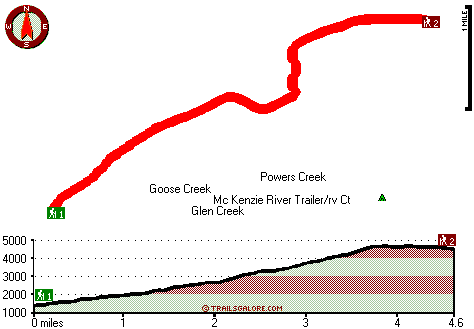
Trailhead 1 to Trailhead 2: Total hiking length = 4.6 miles Total climbing distance = 3.2 miles Difficulty : Difficult Casual Hiking Pace:
5 hours
Fast Hiking Pace:
3 hours
Trailhead 2 to Trailhead 1: Total hiking length = 4.6 miles Total climbing distance = .4 miles Difficulty : Easy Casual Hiking Pace:
3 hours
Fast Hiking Pace:
1.5 hours
| | Trailhead 1 back to Trailhead 1: Total hiking length = 9.2 miles Total climbing distance = 3.6 miles Difficulty : Difficult Casual Hiking Pace:
8 hours
Fast Hiking Pace:
5 hours
Trailhead 2 back to Trailhead 2: Total hiking length = 9.2 miles Total climbing distance = 3.6 miles Difficulty : Difficult Casual Hiking Pace:
8 hours
Fast Hiking Pace:
5 hours
|
Total elevation difference: 3825 feet

Best Western Oakridge Inn, Oakridge
|
33 miles away
This Oakridge, Oregon hotel offers a complimentary continental breakfast each morning and convenient access to a variety of outdoor activities. Discover the Best Western Oakridge Inn, nestled agains...
|
| |
Lodge at Suttle Lake, Sisters
|
35 miles away
We are not your typical hotel. Nestled in the heart of the Deschutes National Forest amid soaring pines. Suttle Lake Resort provides an enchanted escape. Our resorts mountain views and pristine lake w...
|
|
User input for Frissell Point Trail, Central Cascade Range, Lane County, Oregon:

Outdoors Recreation Near Albany-Lebanon, Oregon Very comprehensive list of a variety of outdoors recreation in the vicinity of Albany-Lebanon, Oregon, the metro area neareast to Frissell Point Trail. Find info on campgrounds, hiking trails, ski resorts, lakes, beaches, parks, whitewater and more.
|
Current weather conditions at Frissell Point Trail, Central Cascade Range, Lane County, Oregon

Local climate location: MC KENZIE BRIDGE R S 6 miles away

           
| |
Best Western Ponderosa Lodge, Sisters
|
41 miles away
Offers a refreshing environment with renovated rooms, new deluxe suites and smoke-free accommodations. The perfect choice while traveling the 'Gateway to the Cascades', ideally located on 14 acres sur...
|
Sisters Inn & Suites, Sisters
|
41 miles away
Just a short drive to Redmond and Bend, the Sisters Inn and Suites offers convenience too many local attractions including Downtown Sisters, Fly Fishers Place, Black Butte Ranch, Les Schwab Amphitheat...
|
|
More Hotels and Campgrounds Near Frissell Point Trail, Central Cascade Range, Lane County, Oregon
| |
| |
 |
|
| These outdoors activities are available near Frissell Point Trail. |
| | Trails Near Frissell Point Trail:
 |
Lookout Mountain Trail, Lane County
County
, 4 miles away, 1.6 hiking miles, 527 feet elevation difference |
 |
Saddle Trail, Lane County
County
, 5 miles away, 2.4 hiking miles, 1641 feet elevation difference |
 |
Tipsoo Trail, Lane County
County
, 6 miles away, 8.6 hiking miles, 2848 feet elevation difference |
 |
Pyramid Trail, Lane County
County
, 9 miles away, 8.8 hiking miles, 3174 feet elevation difference |
 |
Browder Ridge Trail, Linn County
County
, 10 miles away, 3.6 hiking miles, 1658 feet elevation difference |
 |
Rebel Rock Trail, Lane County
County
, 10 miles away, 10.6 hiking miles, 3608 feet elevation difference |
|
| | Whitewater Near Frissell Point Trail:
 |
Horse Creek, Lane County
County
, 4 miles away, Class III - 11 miles long (above Separation Creek to McKenzie River) |
 |
Blue River, Linn/ Lane County
County
, 7 miles away, Class IV-V - 4 miles long (Quentin Creek to Blue River Reservoir) |
 |
Lookout Creek, -blank- County
County
, 7 miles away, Class III-IV - 2.5 miles long (2.5 miles above Blue River to Blue River) |
 |
McKenzie River - South Fork, Lane County
County
, 9 miles away, Class III-IV - 6.2 miles long (Dutch Oven Camp to Cougar Reservoir) |
 |
McKenzie River, Lane County
County
, 13 miles away, Class II-III - 40.7 miles long (Olallie Campground to Leaburg Dam) |
|
| | Hotels Near Frissell Point Trail:
 |
Sleepy Hollow Motel, Blue River
, 6 miles away |
 |
Detroit Motel, Detroit
, 27 miles away |
 |
All Season's Motel, Detroit
, 30 miles away |
 |
Lakeside Motel, Detroit
, 30 miles away |
 |
Riverside Inn, Walterville
, 30 miles away |
|
|
|
 |
|