Oregon hiking trails - French Creek Trail, Central Cascade Range, Marion County

   
  The French Creek Trail has been bypassed by logging roads at lower elevations. The trail now starts at about 4000 ft. on the way to Byar's Peak. There are some boulders on the road, one in particular had barely enough room to get by. Great views of Detroit area and Three Sisters from the ridge. Says J. D. Adams
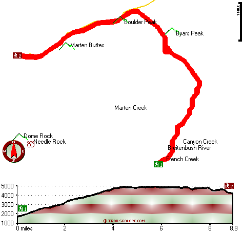
Backcountry hiking in Oregon is such a perfect thing to do. When you're here in Oregon backpacking along one of its hiking trails is so much fun. Put on your backcountry trekking shoes, and hit the backcountry hiking trail, French Creek
    Trail in Marion County, Oregon is a good spot for getting out. You'll must go far from Albany-Lebanon to get to French Creek Trail, but backcountry hiking trails like these are great. French Creek Trail has a total elevation difference of 4,067 feet, and that is higher than average.
Wilderness hiking trails are wonderful and plentiful in Oregon, and French Creek Trail in Marion County is one of them. Being 17.8 miles long; it's longer than many hiking trails. At French Creek Trail during the summer highs are in the 70's, and the night is somewhat cooler of course, usually in the 40's. All through the wintertime this place gets highs in the 40's while the cold winter nights at French Creek Trail are in the 30's. The high level of precipitation makes French Creek Trail a quite wet place; December is when you get the most rain here;  
July on the other hand is the driest. Different parts of this hiking trail are at very different elevations, so keep in mind that you may need to dress differently at different elevations. This is a two-ended trail with two trailheads which means you have the option of backcountry backpacking it one way if you have someone to pick you up at the other end. French Creek Trail is quite long, so make sure you bring plenty of supplies. Of course, this is an overnight backcountry trek, 2.5 days normally, so it's a great thing if your backpack is big enough to do the job. French Creek Trail is a very long backcountry trail having an average number of uphill miles which makes it a magnificent great outdoors hiking trail for experienced backcountry hikers in delightful shape. Please follow all local rules about fires and camping. Backpacking trails like this one here in the Central Cascade Range are a perfect way to explore these mountains. Every single Oregon hiking trail is worth backpacking. This is a neighborhood covered with lots of great outdoors hiking trails.

Briefly about the general area:
If you're here at French Creek Trail, you could take a look at Marten Creek; why not camp at B and B Rentals since you're here at French Creek Trail. Yep, outdoors fun stuff to do are beyond doubt bountiful here at French Creek Trail. Pansy Basin is a great place to stretch your legs a bit. Don't leave French Creek Trail without first paying a visit to Terrace Spring, and whitewater paddling is not for everybody but if it's for you then, we recommend Breitenbush River.
French Creek flows through this region, and get your heart beating on the great whitewater of Santiam River - North. Now, you may imagine that's a load but there's even more amusing stuff to do here in the Central Cascade Range. Beachie Saddle is a pleasant site to pop by nearby, and Detroit Lake State Park is a great local campground.

Location of Trailhead 1: Latitude 44.7429, Longitude -122.156
- - Directions and Road Map

Location of Trailhead 2: Latitude 44.783, Longitude -122.2081
- - Directions and Road Map


Trailhead 1 to Trailhead 2:
Total hiking length = 8.9 miles
Total climbing distance = 5.5 miles
Difficulty : Difficult
Casual Hiking Pace: 9 hours
Fast Hiking Pace: 5 hours

Trailhead 2 to Trailhead 1:
Total hiking length = 8.9 miles
Total climbing distance = 2 miles
Difficulty : Difficult
Casual Hiking Pace: 7 hours
Fast Hiking Pace: 3.5 hours
    Trailhead 1 back to Trailhead 1:
Total hiking length = 17.8 miles
Total climbing distance = 7.5 miles
Difficulty : Difficult
Casual Hiking Pace: 2.5 days
Fast Hiking Pace: 1.5 days

Trailhead 2 back to Trailhead 2:
Total hiking length = 17.8 miles
Total climbing distance = 7.5 miles
Difficulty : Difficult
Casual Hiking Pace: 2.5 days
Fast Hiking Pace: 1.5 days

Total elevation difference: 4067 feet


Resort at the Mountain, Welches
31 miles away
The Resort at The Mountain is the premier Northwest golf and ski resort located in the Highlands of Oregon just an hour east of Portland at the western base of Mt. Hood. The Resort features 160 gues...
  
Whispering Woods (Vri), Welches
31 miles away
Whispering Woods is a resort destination east of Portland which opened in 1981 with 42 condominiums. The second phase of 24 additional condominiums opened in 1992. The resort offers a clubhouse with a...
User input for French Creek Trail, Central Cascade Range, Marion County, Oregon:

Submit Input:
Your Name:
Write or Paste Input here:

Upload picture:      Review Guidelines


Outdoors Recreation Near Albany-Lebanon, Oregon
Very comprehensive list of a variety of outdoors recreation in the vicinity of Albany-Lebanon, Oregon, the metro area neareast to French Creek Trail. Find info on campgrounds, hiking trails, ski resorts, lakes, beaches, parks, whitewater and more.

Current weather conditions at French Creek Trail, Central Cascade Range, Marion County, Oregon
WXPort

Local climate location: SCOTTS MILLS 14 miles away

Best Western Sandy Inn, Sandy
32 miles away
This Sandy, Oregon hotel is an interior corridor hotel offering guests easy access to Mt. Hood, the Rose Garden Convention Center and the Oregon Zoo at Washington Park. Enjoy beautiful mountain view...

Mount Hood Inn, Government Camp
38 miles away
At the Mount Hood Inn we offer our guests the finest accommodations on the mountain. With our modern facilities and friendly local staff we are able to give you the attention and service you have com...

More Hotels and Campgrounds Near French Creek Trail, Central Cascade Range, Marion County, Oregon

OTHER_INFO
  Central Cascade Range Campgrounds
Complete list of all the campgrounds in the Central Cascade Range.

Central Cascade Range Outdoors Info
Complete outdoors info for the Central Cascade Range.

Oregon Hiking Trails
Complete list of all hiking trails in Oregon

Books about hiking trails in Oregon
List of books available on Amazon.com about hiking trails in Oregon.

Oregon Outdoors Index
This is a very comprehensive index of outdoors activities in the great state of Oregon.


TOPO
High quality water resistant topo map of French Creek Trail, Central Cascade Range, Marion County, Oregon.

OUTDOORS_GUIDE
These outdoors activities are available near French Creek Trail.
 Trails Near French Creek Trail:
Beachie Trail, Marion County County , 2 miles away,  13.4 hiking miles, 1518 feet elevation difference
Rocky Top Trail, Marion County County , 4 miles away, 2.7 hiking miles, 526 feet elevation difference
Twin Lakes Trail, Marion County County , 6 miles away,  8.4 hiking miles, 888 feet elevation difference
Whetstone Trail, Clackamas County County , 7 miles away,  3.2 hiking miles, 1456 feet elevation difference
Volcano Trail, Linn County County , 7 miles away, 1.4 hiking miles, 1090 feet elevation difference
Mother Lode Trail, Marion County County , 7 miles away, 10.7 hiking miles, 3313 feet elevation difference
Molalla Trail, Clackamas County County , 8 miles away, 3 hiking miles, 1285 feet elevation difference
 Camp Grounds Near French Creek Trail:
B and B Rentals, Detroit, 2 miles away
Detroit Lake State Park, -blank-, 2 miles away
Skookum Lake Campground, Clackamas County, 11 miles away
Cascade Sports Camp, Lyons, 15 miles away
Country Star Recreational Vehicle Park, Foster, 19 miles away
 Whitewater Near French Creek Trail:
Breitenbush River, Marion County County , 7 miles away, Class IV - 8.2 miles long (Cleator Bend Campground to Detroit Lake)
Santiam River - North, Marion/ Linn County County , 7 miles away, Class III-IV - 7.3 miles long (Bruno Mt. Road Bridge to Detroit Reservoir)
Santiam River - North, Marion/ Linn County County , 11 miles away, Class III-V - 4.7 miles long (Big Cliff Dam to Packsaddle Park)
Elkhorn Creek, -blank- County County , 12 miles away, Class III-V - 10 miles long (to confluence with Little North Santiam)
Collawash River, Marion County County , 13 miles away, Class III-IV(V) - 5 miles long (Elk Lake Creek to river mile 5.5)
 Hotels Near French Creek Trail:
Resort at the Mountain, Welches , 31 miles away
Whispering Woods (Vri), Welches , 31 miles away
Best Western Sandy Inn, Sandy , 32 miles away
Mount Hood Inn, Government Camp , 38 miles away
Howard Johnson Gresham, Gresham , 40 miles away
 Lakes Near French Creek Trail
Giebeler Lake, Marion County , 3 miles away

Outdoors related information copyright © Stratus-Pikpuk, Inc. - Detailed hotel information copyright © Interactive Hotel Solutions