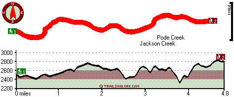
Oregon hiking trails - Freezeout Trail, Southern Cascade Range, Douglas County

   
  Freezeout Trail is a long trip away from Medford, but there's brilliant natural prettiness right here for you along it. Backcountry hiking in Oregon never gets boring. Oregon is a good spot for outdoors people. The total elevation difference for this backpacking trail is 583 feet which is a lower than average number. Hitting the hiking trails is always an enjoyable thing to do, and if you happen to be in Douglas County of Oregon, Freezeout Trail is a great local hiking trail for doing a bit of leg stretching. Oregon has plenty of good backcountry trails;
    Freezeout Trail is one of them, and it's in Douglas County. Freezeout Trail is a wet spot that gets a large amount of rainfall; November is the wettest month with most rain, and the driest month of the year is July. This great outdoors hiking trail sometimes gets very dry, so don’t
forget to check for any current fire restrictions before you go. All through the summertime, highs regularly are in the 80's at Freezeout Trail, and the nighttime is a little cooler of course, usually in the 40's. Highs all through the winter are usually in the 40's, and after the sun is down all through the winter temperatures at Freezeout Trail descend into the 30's. Please follow all local rules about fires and camping. Each backcountry trail in Oregon is lovely in its own way. These backpacking trails here in the Southern Cascade Range are the best  
way to enjoy these highlands. Being 9.6 miles long; it's a long hiking trail. You spend the whole hike in roughly the same elevation zone which means the conditions are about the same from start to finish. Keep in mind that this is a long great outdoors hiking trail, so don't forget to pack enough supplies. You should count on this walk taking about 9 hours, but you never know stuff could go wrong and you could get stuck so be prepared for that. This is just one of a large number of backpacking trails in this neighborhood. Freezeout Trail is a two ended backpacking trail with two trailheads which means you have the option of backpacking it one way if you have someone to pick you up at the other end. Freezeout Trail is many miles long having an average number of uphill miles which makes this a very tough backpacking trail for advanced walkers looking for a great challenge.

Briefly about the general area:
Yep, outdoors exciting stuff to do are in fact abundant here at Freezeout Trail. You'll need more than a day to look at everything Freezeout Trail has to offer, you can camp at Huckleberry Lake Campground; don't forget to take a perfect little visit to Surveyor Creek. There are some magnificent whitewater spots on Jackson Creek; you're sure to run into some wonderful people from Medford here.
Stay the night at Tiller RV Park, and it's a brilliant idea to go to Coffin Creek. Just can't get enough of the Southern Cascade Range. A short tour to Red Lick Spring is always worthwhile, and some delightful nature is available in South Umpqua Experimental Forest. Junction Spring is an inspiring spot to go to during your stay; Bunchgrass Meadows is a pleasant site to stretch your legs a bit.
And if that's not sufficient there's a heap more cool things to do in the Southern Cascade Range. There's whitewater on Umpqua River - South for all you thrill seekers.

Location of Trailhead 1: Latitude 42.969, Longitude -122.8169
- - Directions and Road Map

Location of Trailhead 2: Latitude 42.9728, Longitude -122.7425
- - Directions and Road Map


Trailhead 1 to Trailhead 2:
Total hiking length = 4.8 miles
Total climbing distance = 2.5 miles
Difficulty : Medium
Casual Hiking Pace: 4.5 hours
Fast Hiking Pace: 2.5 hours

Trailhead 2 to Trailhead 1:
Total hiking length = 4.8 miles
Total climbing distance = 2 miles
Difficulty : Medium
Casual Hiking Pace: 4 hours
Fast Hiking Pace: 2.5 hours
    Trailhead 1 back to Trailhead 1:
Total hiking length = 9.6 miles
Total climbing distance = 4.5 miles
Difficulty : Difficult
Casual Hiking Pace: 9 hours
Fast Hiking Pace: 6 hours

Trailhead 2 back to Trailhead 2:
Total hiking length = 9.6 miles
Total climbing distance = 4.5 miles
Difficulty : Difficult
Casual Hiking Pace: 9 hours
Fast Hiking Pace: 6 hours

Total elevation difference: 583 feet


Super 8 Motel Medford OR, Medford
30 miles away
75 Rooms Indoor Heated Pool with an 80 Foot Waterslide Indoor Spa Easy Access Off I-5 Within 1 Mile From The Jacksonville Medford International Airport Within 3 Miles to Rogue Valley Regiona...
  
Fairfield Inn And Suites By Marriott Medford, Central Point
31 miles away
Always fresh, always clean, our guest rooms are full of thoughtful amenities, including a well-lit work desk and a remote-controlled TV with free cable. We'll get you started each day with a complimen...
User input for Freezeout Trail, Southern Cascade Range, Douglas County, Oregon:

Submit Input:
Your Name:
Write or Paste Input here:

Upload picture:      Review Guidelines


Outdoors Recreation Near Medford, Oregon
Very comprehensive list of a variety of outdoors recreation in the vicinity of Medford, Oregon, the metro area neareast to Freezeout Trail. Find info on campgrounds, hiking trails, ski resorts, lakes, beaches, parks, whitewater and more.

Current weather conditions at Freezeout Trail, Southern Cascade Range, Douglas County, Oregon
WXPort

Local climate location: IDLEYLD PARK 18 miles away

Courtyard by Marriott Medford Airport, Medford
31 miles away
Open in July 2005, the Medford Airport Courtyard is located minutes from downtown Medford and Central Point. Travelers can experience the beauty of Southern Oregon by rafting on the Rogue River or at...

Holiday Inn Express Hotel & Suites MEDFORD-CENTRAL POINT, Central Point
31 miles away
The new Holiday Inn Express Hotel & Suites Medford Central Point Oregon is your gateway to Southern Oregon and located only minutes from Rogue Valley Medford Intl. Airport (MFR). This hotel is a grea...

More Hotels and Campgrounds Near Freezeout Trail, Southern Cascade Range, Douglas County, Oregon

OTHER_INFO
  Southern Cascade Range Campgrounds
Complete list of all the campgrounds in the Southern Cascade Range.

Southern Cascade Range Outdoors Info
Complete outdoors info for the Southern Cascade Range.

Oregon Hiking Trails
Complete list of all hiking trails in Oregon

Books about hiking trails in Oregon
List of books available on Amazon.com about hiking trails in Oregon.

Oregon Outdoors Index
This is a very comprehensive index of outdoors activities in the great state of Oregon.


TOPO
High quality water resistant topo map of Freezeout Trail, Southern Cascade Range, Douglas County, Oregon.

OUTDOORS_GUIDE
These outdoors activities are available near Freezeout Trail.
 Trails Near Freezeout Trail:
Billick Burn Trail, Douglas County County , 5 miles away, 2.3 hiking miles, 1263 feet elevation difference
Fawn Camp Trail, Douglas County County , 5 miles away, 3.3 hiking miles, 859 feet elevation difference
Rattlesnake Trail, Douglas County County , 6 miles away, 2.3 hiking miles, 863 feet elevation difference
Rogue-Umpqua Divide Trail, Douglas County County , 8 miles away,  5 hiking miles, 603 feet elevation difference
Straight Creek Trail, Douglas County County , 8 miles away, 4.3 hiking miles, 2918 feet elevation difference
North and South Trail, Douglas County County , 9 miles away, 1.1 hiking miles, 1098 feet elevation difference
Tison Trail, Douglas County County , 9 miles away, 3.8 hiking miles, 2444 feet elevation difference
 Camp Grounds Near Freezeout Trail:
Tiller RV Park, Tiller, 7 miles away
Huckleberry Lake Campground, Douglas County, 12 miles away
West Fork Trail Creek Mill, Trail, 12 miles away
Neal Springs Campground, Douglas County, 12 miles away
Tiller Ranger District, Tiller, 12 miles away
 Whitewater Near Freezeout Trail:
Jackson Creek, Douglas County County , 2 miles away, Class III-IV - 8 miles long (Cover Camp to FS 31)
Umpqua River - South, Douglas County County , 4 miles away, Class III-IV - 12 miles long (Campbell Falls to Three C Rock)
Jackson Creek, Douglas County County , 11 miles away, Class IV(V) - 8 miles long (NF300 to Cover Camp)
Umpqua River - South, Douglas County County , 11 miles away, Class III-IV - 8.5 miles long (Three C Rocks to MP 22)
Little River, Douglas County County , 13 miles away, Class -blank- - 8 miles long (FS Road 165 to White Creek Campground)
 National Parks Near Freezeout Trail:
Crater Lake National Park, Crater Lake - OR , 45 miles away
 Hotels Near Freezeout Trail:
Super 8 Motel Medford OR, Medford , 30 miles away
Fairfield Inn And Suites By Marriott Medford, Central Point , 31 miles away
Courtyard by Marriott Medford Airport, Medford , 31 miles away
Holiday Inn Express Hotel & Suites MEDFORD-CENTRAL POINT, Central Point , 31 miles away
Candlewood Suites MEDFORD, Medford , 31 miles away
 Lakes Near Freezeout Trail
Beaver Lake, Douglas County , 3 miles away

Outdoors related information copyright © Stratus-Pikpuk, Inc. - Detailed hotel information copyright © Interactive Hotel Solutions