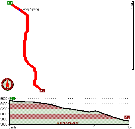
Oregon hiking trails - Farley Spring Trail, Blue Mountains, Grant County

   
  Farley Spring Trail is a hiking trail quite far from Pendleton-Hermiston, but it is a brilliant hiking trail. Hiking here in Oregon is a must. Put on your backpacking shoes, and hit the hiking trail, Farley Spring Trail in Grant County, Oregon is a brilliant place to go. This is just one of a large number of great outdoors trails in this region. This area does get very dry sometimes, so do check for current fire restrictions before you go if you plan to bring a stove or make a camp fire. Don’t forget to check for any current restrictions or closures
    before you go. Farley Spring Trail stays roughly within the same elevation zone the whole time, so you get pretty much the same conditions along the whole backpacking trail. Farley Spring Trail is not that long but it's always delightful to bring some emergency supplies, you never
know what could happen. Farley Spring Trail is 2.8 miles long it's a shorter type backcountry hike. Farley Spring Trail is pretty waterless usually; November is the wettest month with most rain while July is the month with the least amount of precipitation. Backcountry trails like this one here in the Blue Mountains are the best way to enjoy these hills. Each trail in Oregon is well worth a trek. The total elevation difference for this hiking trail is 925 feet which is lower than average. Hiking here in Oregon is always a cool thing to do. This backcountry  
trek shouldn't take more than 2.5 hours, but you never know stuff could go wrong and you could get stuck so be prepared for that. There are trails all over Oregon, and Farley Spring Trail in Grant County is one of them. Farley Spring Trail is a very short great outdoors hiking trail having an average number of uphill miles which makes it a fine great outdoors trail for the average person looking for a fine adventure. Throughout the summertime months highs here at Farley Spring Trail reach the 80's. All through the moonlight hours it's ordinarily in the 30's. Highs during the wintertime are ordinarily in the 30's; overnight lows at Farley Spring Trail during the wintertime ordinarily sink into the 10's. This hiking trail has two trailheads which means you have the option of backcountry trekking it one way if you have someone to pick you up at the other end.

Briefly about the general area:
You'll need more than a day to look at everything Farley Spring Trail has to offer, you can camp at Deerhorn Campground. There's so much to do here at Farley Spring Trail that you need to camp here for a while, Trough Creek Campground is a good location for that. There's just no way someone can get bored here at Farley Spring Trail.
The surroundings of this river have so much to offer. Line Creek flows through this region; do put some time aside to spend at Sunset Spring while you're here at Farley Spring Trail. While you're here at Farley Spring Trail it's a pleasant idea to take a look at Desolation Meadows, and a quick spree to Skinner Creek is without doubt a perfect idea. All year is a perfect time in the Blue Mountains if you fancy the outdoors. It's always splendid to check out Farley Spring, and there's whitewater on John Day River - North Fork for all you adrenaline kick people.

Location of Trailhead 1: Latitude 44.8422, Longitude -118.6552
- - Directions and Road Map

Location of Trailhead 2: Latitude 44.8236, Longitude -118.6484
- - Directions and Road Map


Trailhead 1 to Trailhead 2:
Total hiking length = 1.4 miles
Total climbing distance = 0 miles
Difficulty : Easy
Casual Hiking Pace: 1 hours
Fast Hiking Pace: .5 hours

Trailhead 2 to Trailhead 1:
Total hiking length = 1.4 miles
Total climbing distance = 1.1 miles
Difficulty : Medium
Casual Hiking Pace: 1.5 hours
Fast Hiking Pace: 1 hours
    Trailhead 1 back to Trailhead 1:
Total hiking length = 2.8 miles
Total climbing distance = 1.1 miles
Difficulty : Medium
Casual Hiking Pace: 2.5 hours
Fast Hiking Pace: 1.5 hours

Trailhead 2 back to Trailhead 2:
Total hiking length = 2.8 miles
Total climbing distance = 1.1 miles
Difficulty : Medium
Casual Hiking Pace: 2.5 hours
Fast Hiking Pace: 1.5 hours

Total elevation difference: 925 feet


Best Western John Day Inn, John Day
29 miles away
This charming John Day, Oregon hotel is minutes from a variety of outdoor activities and walking distance from many local shops and restaurants. Located in Eastern Oregon's beautiful John Day Valley...
  
Americas Best Value Inn, John Day
29 miles away
User input for Farley Spring Trail, Blue Mountains, Grant County, Oregon:

Submit Input:
Your Name:
Write or Paste Input here:

Upload picture:      Review Guidelines


Outdoors Recreation Near Pendleton-Hermiston, Oregon
Very comprehensive list of a variety of outdoors recreation in the vicinity of Pendleton-Hermiston, Oregon, the metro area neareast to Farley Spring Trail. Find info on campgrounds, hiking trails, ski resorts, lakes, beaches, parks, whitewater and more.

Current weather conditions at Farley Spring Trail, Blue Mountains, Grant County, Oregon
WXPort

Local climate location: UKIAH 13 miles away

Rugged Country Lodge DBA Double H Investments, Pendleton
38 miles away
Rugged Country Lodge: Pendleton's only 'bed-and-breakfast motel.' Completely renovated. All non-smoking. Affordable rates. Luxury queen beds. Down bedding. Fridges and microwaves. Air-conditioning. Fr...

Pendleton Super 8 Motel, Pendleton
41 miles away
Complimentary SuperStart Breakfast, indoor heated pool and whirlpool, free Wireless High Speed Internet, Direct TV - w/5 HBO, suites w/jacuzzi, micro-fridge, pets allowed w/permission ($10 non refunda...

More Hotels and Campgrounds Near Farley Spring Trail, Blue Mountains, Grant County, Oregon

OTHER_INFO
  Blue Mountains Campgrounds
Complete list of all the campgrounds in the Blue Mountains.

Blue Mountains Outdoors Info
Complete outdoors info for the Blue Mountains.

Oregon Hiking Trails
Complete list of all hiking trails in Oregon

Books about hiking trails in Oregon
List of books available on Amazon.com about hiking trails in Oregon.

Oregon Outdoors Index
This is a very comprehensive index of outdoors activities in the great state of Oregon.


TOPO
High quality water resistant topo map of Farley Spring Trail, Blue Mountains, Grant County, Oregon.

OUTDOORS_GUIDE
These outdoors activities are available near Farley Spring Trail.
 Trails Near Farley Spring Trail:
Cold Spring Trail, Grant County County , 2 miles away, 9 hiking miles, 1738 feet elevation difference
Lost Camp Trail, Grant County County , 2 miles away, 4.3 hiking miles, 1748 feet elevation difference
Glade Creek Trail, Grant County County , 2 miles away,  13.6 hiking miles, 2882 feet elevation difference
Spruce Log Trail, Grant County County , 3 miles away, 1.4 hiking miles, 421 feet elevation difference
Sunset Trail, Grant County County , 3 miles away, 3.3 hiking miles, 1656 feet elevation difference
Basin Creek Trail, Grant County County , 4 miles away,  5.8 hiking miles, 622 feet elevation difference
Jumpoff Joe Trail, Grant County County , 4 miles away, 3.7 hiking miles, 2572 feet elevation difference
 Camp Grounds Near Farley Spring Trail:
Deerhorn Campground, Grant County, 11 miles away
Trough Creek Campground, Umatilla County, 16 miles away
Corrigal Spring Campground, Grant County, 19 miles away
Lehman Hot Springs, Ukiah, 19 miles away
 Whitewater Near Farley Spring Trail:
John Day River - North Fork, Grant/ Umatilla County County , 6 miles away, Class II-III - 41 miles long (Route 52 Bridge to Dale)
 National Parks Near Farley Spring Trail:
John Day Fossil Beds National Monument, Kimberly - OR , 65 miles away
 Hotels Near Farley Spring Trail:
Lodge At Granite, Sumpter , 16 miles away
Sag's Motel, Prairie City , 18 miles away
Antlers Inn, Ukiah , 24 miles away
Dreamers Lodge Motel, John Day , 29 miles away
Best Western John Day Inn, John Day , 29 miles away

Outdoors related information copyright © Stratus-Pikpuk, Inc. - Detailed hotel information copyright © Interactive Hotel Solutions