| |
|
| | Oregon has lots of outdoors activities. Ok, you've been cooped up too long, time to get out in the great outdoors a bit, and East Fork Way in Marion County, Oregon is a glorious pick. Oregon has plenty of great hiking and backpacking trails; one of them being East Fork Way in Marion County. East Fork Way is not that long but you should still bring some emergency supplies just in case something happens. During the summertime here at East Fork Way, high temperatures typically get into the 70's. Once the sun is down it falls down to the 50's. The wintertime |
|
comes with highs in the 40's with temperatures at East Fork Way dipping down into the 30's all through winter nights. This is one of many wilderness hiking trails in the surrounding neighborhood. It's a long trip from Hood River to East Fork Way, but backpacking trails like these
| | are pleasant. Here in Oregon backcountry hiking is so much fun. And keep in mind that there could be temporary safety restrictions in location. The time needed for this trek is roughly 3.5 hours, but of course some folks walk a bit slower and some a bit faster. Wilderness trails like this one here in the Central Cascade Range are the best way to enjoy these summits. East Fork Way has a total elevation difference of 913 feet, and that is lower than average. East Fork Way gets a lot of water; December is the month that gets the most rain, and July is the | |
|
month with the least moisture. Being 4.2 miles long it's a mid length walk. There are two trailheads to chose from, one in each end, so backcountry hiking it one way is an option if you can arrange for a ride back. There's not much difference in elevation along the hiking and backpacking
trail which means the conditions are about the same from start to finish. This great outdoors trail sometimes gets very dry, so don’t forget to check for any current fire restrictions before you go. There are plenty of hiking and backpacking trails in Oregon; each one of them is
well worth a trek. This hiking trail is a mid length hiking trail having an average number of uphill miles which makes it a nice wilderness hiking trail for the average person looking for a nice adventure.
Briefly about the general area: B and B Rentals is a great campground
nearby, and some of the water nearby flows, like Cachebox Creek. Not enough hours in a day to enjoy the Central Cascade Range. East Fork Way is a glorious spot to visit for more than one day, Detroit Lake State Park is a glorious spot to camp nearby; swing by Gyp Creek it's a brilliant
place to stop by. There's whitewater on Collawash River for all you adrenaline kick people; get your heart beating on the great whitewater of Breitenbush River.
|
|
Location of Trailhead 1: Latitude 44.8346, Longitude -122.0002 - - Directions and Road Map
Location of Trailhead 2: Latitude 44.8573, Longitude -121.9868 - - Directions and Road Map

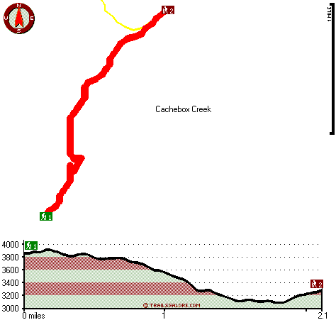
Trailhead 1 to Trailhead 2: Total hiking length = 2.1 miles Total climbing distance = .6 miles Difficulty : Easy Casual Hiking Pace:
1.5 hours
Fast Hiking Pace:
1 hours
Trailhead 2 to Trailhead 1: Total hiking length = 2.1 miles Total climbing distance = 1.2 miles Difficulty : Medium Casual Hiking Pace:
2 hours
Fast Hiking Pace:
1 hours
| | Trailhead 1 back to Trailhead 1: Total hiking length = 4.2 miles Total climbing distance = 1.8 miles Difficulty : Medium Casual Hiking Pace:
3.5 hours
Fast Hiking Pace:
2.5 hours
Trailhead 2 back to Trailhead 2: Total hiking length = 4.2 miles Total climbing distance = 1.8 miles Difficulty : Medium Casual Hiking Pace:
3.5 hours
Fast Hiking Pace:
2.5 hours
|
Total elevation difference: 913 feet

Whispering Woods (Vri), Welches
|
24 miles away
Whispering Woods is a resort destination east of Portland which opened in 1981 with 42 condominiums. The second phase of 24 additional condominiums opened in 1992. The resort offers a clubhouse with a...
|
| |
Resort at the Mountain, Welches
|
24 miles away
The Resort at The Mountain is the premier Northwest golf and ski resort located in the Highlands of Oregon just an hour east of Portland at the western base of Mt. Hood. The Resort features 160 gues...
|
|
User input for East Fork Way, Central Cascade Range, Marion County, Oregon:

Outdoors Recreation Near Hood River, Oregon Very comprehensive list of a variety of outdoors recreation in the vicinity of Hood River, Oregon, the metro area neareast to East Fork Way. Find info on campgrounds, hiking trails, ski resorts, lakes, beaches, parks, whitewater and more.
More Hotels and Campgrounds Near East Fork Way, Central Cascade Range, Marion County, Oregon
| |
| |
 |
|
| These outdoors activities are available near East Fork Way. |
| | Trails Near East Fork Way:
 |
Scorpion Mountain Trail, Marion County
County
, 1 miles away, 0.5 hiking miles, 176 feet elevation difference |
 |
Janus Butte Trail, Marion County
County
, 2 miles away, 8.2 hiking miles, 2376 feet elevation difference |
 |
Scorpion Ridge Trail, Marion County
County
, 2 miles away, 7.6 hiking miles, 2625 feet elevation difference |
 |
Round Lake Trail, Marion County
County
, 3 miles away, 3.5 hiking miles, 1470 feet elevation difference |
 |
Fox Creek Trail, Marion County
County
, 3 miles away, 7.2 hiking miles, 1917 feet elevation difference |
 |
Humbug Ridge Trail, Marion County
County
, 3 miles away, 6.9 hiking miles, 1523 feet elevation difference |
 |
Thomas Trail, Marion County
County
, 4 miles away, 1.4 hiking miles, 489 feet elevation difference |
|
| | Whitewater Near East Fork Way:
 |
Collawash River, Marion County
County
, 5 miles away, Class III-IV(V) - 5 miles long (Elk Lake Creek to river mile 5.5) |
 |
Breitenbush River, Marion County
County
, 7 miles away, Class IV - 8.2 miles long (Cleator Bend Campground to Detroit Lake) |
 |
Collawash River, Marion County
County
, 9 miles away, Class IV - 5.5 miles long (Mile 5.5 bridge to Two Rivers Picnic Area) |
 |
Clackamas River, Clackamas County
County
, 9 miles away, Class III-IV - 8 miles long (June Creek Br. to Collawash River) |
 |
Santiam River - North, Marion/ Linn County
County
, 9 miles away, Class III-IV - 7.3 miles long (Bruno Mt. Road Bridge to Detroit Reservoir) |
|
| | Hotels Near East Fork Way:
 |
Whispering Woods (Vri), Welches
, 24 miles away |
 |
Resort at the Mountain, Welches
, 24 miles away |
 |
Mount Hood Inn, Government Camp
, 27 miles away |
 |
Lodge at Suttle Lake, Sisters
, 33 miles away |
 |
Best Western Sandy Inn, Sandy
, 34 miles away |
|
|
|
 |
|