| |
|
| | Put on your backcountry hiking shoes, and hit the great outdoors hiking trail, Dry Ridge Trail in Clackamas County, Oregon is a great place to go. Dry Ridge Trail is a long trip away from Hood River, but many people like to backcountry walk here to be in close proximity to the fresh air. If you happen to be in Oregon, why not go backpacking, it is an excellent idea. While visiting this vicinity in Oregon it's a good idea to go backcountry hiking too. Being 8.6 miles long it's an average length backcountry hiking trail. Backpacking trails are brilliant |
|
and plentiful in Oregon; among these are Dry Ridge Trail in Clackamas County. The time needed for this hike is roughly 7.5 hours, but you never know stuff could go wrong and you could get stuck so be prepared for that. This is a long backpacking and hiking trail, so don't forget
| | to pack enough supplies. The pretty backpacking and hiking trails of the Central Cascade Range are a good way to explore these highlands. Some parts of Dry Ridge Trail are much higher up than other parts of the backcountry hiking trail, and that means that some parts of the backcountry hiking trail could be very different from other parts of it. The length of this backpacking and hiking trail is about average having an average number of uphill miles which makes this great outdoors trail great for hard core backpackers looking for adventure. Please follow all | |
|
local rules about fires and camping. Dry Ridge Trail has a total elevation difference of 3,204 feet, and that is higher than average. Sometimes this backpacking and hiking trail gets really dry, so don’t forget to check for any current fire restrictions before you go. Each one
of the many wilderness hiking trails of Oregon is scenic in its own way. This is a region covered with lots of great outdoors trails. Dry Ridge Trail is a one trailhead wilderness hiking trail, so you're looking at an in and out backcountry walk. Throughout the summertime months,
highs frequently are in the 70's at Dry Ridge Trail. Once the sun is down it descends down to the 50's. Highs during the wintertime are usually in the 40's with temperatures at Dry Ridge Trail dipping down into the 30's during winter nights. Dry Ridge Trail sees pretty high levels
of rain; the month with most of the rain is December; July meanwhile is the driest month.
Briefly about the general area: Get yourself into a kayak and hit Clackamas River, and Cat Creek is near Dry Ridge Trail and is always a diversion to check out. You truly ought
to fancy the Central Cascade Range. Dinner Creek is one of the streams nearby that might be worth visiting, and a delightful location to camp here at Dry Ridge Trail is Lookout Springs Campground. Get wet paddling on Roaring River, and why not camp at Pelton Park since you're here at Dry Ridge Trail. Since you're here at Dry Ridge Trail why not stop by The Narrows.
|
|
Location of Trailhead: Latitude 45.1587, Longitude -122.1164 - - Directions and Road Map
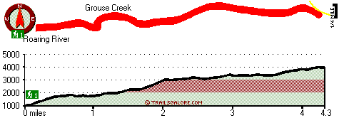
Total in and out hiking length = 8.6 miles
Total climbing distance = 3.8 miles
Difficulty : Difficult
Casual Hiking Pace:
7.5 hours
Fast Hiking Pace:
5 hours
Total elevation difference: 3204 feet

Resort at the Mountain, Welches
|
12 miles away
The Resort at The Mountain is the premier Northwest golf and ski resort located in the Highlands of Oregon just an hour east of Portland at the western base of Mt. Hood. The Resort features 160 gues...
|
| |
Whispering Woods (Vri), Welches
|
12 miles away
Whispering Woods is a resort destination east of Portland which opened in 1981 with 42 condominiums. The second phase of 24 additional condominiums opened in 1992. The resort offers a clubhouse with a...
|
|
User input for Dry Ridge Trail, Central Cascade Range, Clackamas County, Oregon:

Outdoors Recreation Near Hood River, Oregon Very comprehensive list of a variety of outdoors recreation in the vicinity of Hood River, Oregon, the metro area neareast to Dry Ridge Trail. Find info on campgrounds, hiking trails, ski resorts, lakes, beaches, parks, whitewater and more.
More Hotels and Campgrounds Near Dry Ridge Trail, Central Cascade Range, Clackamas County, Oregon
| |
| |
 |
|
| These outdoors activities are available near Dry Ridge Trail. |
| | Trails Near Dry Ridge Trail:
 |
Roaring River Trail, Clackamas County
County
, 4 miles away, 7.2 hiking miles, 4083 feet elevation difference |
 |
Fanton Plaza Trail, Clackamas County
County
, 4 miles away, 4.8 hiking miles, 1787 feet elevation difference |
 |
Old Baldy Trail, Clackamas County
County
, 5 miles away, 11 hiking miles, 638 feet elevation difference |
 |
Eagle Creek Cutoff, Clackamas County
County
, 5 miles away, 7.3 hiking miles, 2830 feet elevation difference |
 |
Cold Spring Trail, Clackamas County
County
, 6 miles away, 4.2 hiking miles, 1284 feet elevation difference |
 |
Bagby Trail, Clackamas County
County
, 8 miles away, 2.7 hiking miles, 602 feet elevation difference |
 |
Cottonwood Meadows Trail, Clackamas County
County
, 9 miles away, 2.5 hiking miles, 1564 feet elevation difference |
|
| | Whitewater Near Dry Ridge Trail:
 |
Roaring River, Clackamas County
County
, 1 miles away, Class III-IV - 3 miles long (Road 4611 to Roaring River Campground) |
 |
Clackamas River, Clackamas County
County
, 4 miles away, Class -blank- - 9.2 miles long (Collawash River to Three Lynx Power Station) |
 |
Clackamas River - Oak Grove Fork, Clackamas County
County
, 6 miles away, Class III-V(V+) - 5 miles long (Lower Five Miles to Clackamas River) |
 |
Collawash River, Marion County
County
, 8 miles away, Class IV - 5.5 miles long (Mile 5.5 bridge to Two Rivers Picnic Area) |
 |
Clackamas River, Clackamas County
County
, 9 miles away, Class III-IV - 12.5 miles long (Three Lynx Power Station to North Fork Reservoir) |
|
| | Hotels Near Dry Ridge Trail:
 |
Resort at the Mountain, Welches
, 12 miles away |
 |
Whispering Woods (Vri), Welches
, 12 miles away |
 |
Best Western Sandy Inn, Sandy
, 18 miles away |
 |
Mount Hood Inn, Government Camp
, 23 miles away |
 |
Best Western Columbia River Inn, Cascade Locks
, 27 miles away |
|
|
|
 |
|