| |
|
| | When was the last time you got out in the fresh air a bit? Diamond Peak Trail in Lane County, Oregon is a nice pick. Great hiking and backpacking trails in Oregon are in abundance, and among these are Diamond Peak Trail in Lane County. Trekking here in Oregon never gets boring. There's not much difference in elevation along the trail, so you won’t have to worry about different climate zones along your backcountry walk. Because Diamond Peak Trail is very far away from modern life, it is a really wonderful hiking trail. Summertime at Diamond Peak Trail |
|
arrives with high temperatures in the 80's with night lows in the 40's. All through the wintertime the highs are regularly in the 40's, and throughout the dark hours in the wintertime at Diamond Peak Trail temperatures fall to the 20's. With its 10.4 miles of walking distance;
| | it's longer than many trails. The trails of the Central Cascade Range are a really glorious way to spend quality time in the fresh air. Each hiking and backpacking trail in Oregon has its own unique loveliness. Sometimes this backpacking trail gets really dry, so don’t forget to check for any current fire restrictions before you go. The total elevation difference for Diamond Peak Trail is 1,462 feet which is about average. The time needed for this hike is roughly 9 hours, but of course some folks walk a bit slower and some a bit faster. This is a long | |
|
backpacking trail, so make sure you bring plenty of supplies. Diamond Peak Trail has two trailheads, so backcountry trekking it one way is an option if you can arrange for a ride back. Lots of rainfall falls at Diamond Peak Trail; December is the month that gets the most rain,
and the driest of the months is July. This trail is many miles long having an average number of uphill miles which makes this wilderness hiking trail good for hard core backpackers looking for adventure. Oregon is a perfect place for outdoors people. This is an area covered with
lots of wilderness hiking trails. And keep in mind that there could be temporary safety restrictions in spot.
Briefly about the general area: Be careful coming to the Central Cascade Range, you might not ever want to go home again. Indigo Springs is always fun to check
out; Paddys Valley is another great location to check out close by. If you came for an overnight stay Lake Lucile Campground is a great site to camp; everyone loves Wolf Prairie. Yeah, come up here to the Central Cascade Range for a pleasant time. Why not camp at Shelter Cove
Resort since you're here at Diamond Peak Trail, and float down the rapids of Hills Creek in a kayak. Yep, outdoors fun things to do are in fact plentiful here at Diamond Peak Trail. Take a little spree to Bear Creek while you're here at Diamond Peak Trail, and do put some time
aside to spend at Chuckle Springs if you're here at Diamond Peak Trail. Some close by water includes Scout Creek, and get yourself into a kayak and hit Salt Creek.
|
|
Location of Trailhead 1: Latitude 43.5668, Longitude -122.1996 - - Directions and Road Map
Location of Trailhead 2: Latitude 43.5175, Longitude -122.2193 - - Directions and Road Map

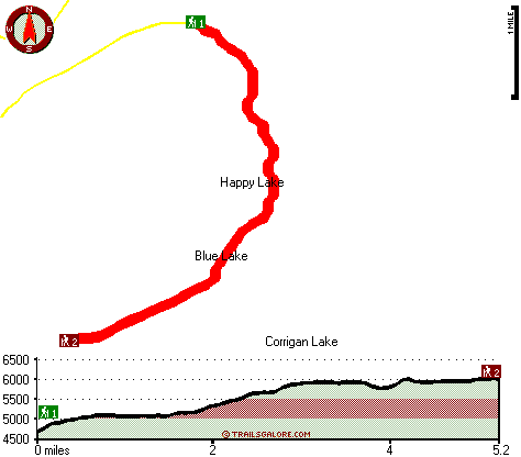
Trailhead 1 to Trailhead 2: Total hiking length = 5.2 miles Total climbing distance = 3.2 miles Difficulty : Medium Casual Hiking Pace:
5 hours
Fast Hiking Pace:
3 hours
Trailhead 2 to Trailhead 1: Total hiking length = 5.2 miles Total climbing distance = 1.1 miles Difficulty : Easy Casual Hiking Pace:
4 hours
Fast Hiking Pace:
2 hours
| | Trailhead 1 back to Trailhead 1: Total hiking length = 10.4 miles Total climbing distance = 4.3 miles Difficulty : Difficult Casual Hiking Pace:
9 hours
Fast Hiking Pace:
6 hours
Trailhead 2 back to Trailhead 2: Total hiking length = 10.4 miles Total climbing distance = 4.3 miles Difficulty : Difficult Casual Hiking Pace:
9 hours
Fast Hiking Pace:
6 hours
|
Total elevation difference: 1462 feet

Best Western Oakridge Inn, Oakridge
|
23 miles away
This Oakridge, Oregon hotel offers a complimentary continental breakfast each morning and convenient access to a variety of outdoor activities. Discover the Best Western Oakridge Inn, nestled agains...
|
| |
Best Western Newberry Station, La Pine
|
49 miles away
Stay at this La Pine, Oregon hotel, a central location to five of the major recreational areas in Oregon including Crater Lake and the 14 lake Cascade Lakes. Welcome to the Best Western Newberry Sta...
|
|
User input for Diamond Peak Trail, Central Cascade Range, Lane County, Oregon:

Outdoors Recreation Near Klamath Falls, Oregon Very comprehensive list of a variety of outdoors recreation in the vicinity of Klamath Falls, Oregon, the metro area neareast to Diamond Peak Trail. Find info on campgrounds, hiking trails, ski resorts, lakes, beaches, parks, whitewater and more.
More Hotels and Campgrounds Near Diamond Peak Trail, Central Cascade Range, Lane County, Oregon
| |
| |
 |
|
| These outdoors activities are available near Diamond Peak Trail. |
| | Trails Near Diamond Peak Trail:
 |
Pinto Mountain Way, Lane County
County
, 3 miles away, 3.9 hiking miles, 829 feet elevation difference |
 |
Hills Creek Trail, Lane County
County
, 3 miles away, 2.5 hiking miles, 1224 feet elevation difference |
 |
Swift Creek Trail, Lane County
County
, 3 miles away, 5.8 hiking miles, 2139 feet elevation difference |
 |
Juniper Trail, Lane County
County
, 3 miles away, 5.9 hiking miles, 558 feet elevation difference |
 |
Bear Mountain Trail, Lane County
County
, 4 miles away, 2.8 hiking miles, 2998 feet elevation difference |
 |
Wolf Mountain Trail, Lane County
County
, 4 miles away, 7.8 hiking miles, 2543 feet elevation difference |
 |
Happy Prairie Way, Douglas County
County
, 5 miles away, 2.9 hiking miles, 2706 feet elevation difference |
|
| | Whitewater Near Diamond Peak Trail:
 |
Hills Creek, Lane County
County
, 12 miles away, Class IV - 6 miles long (6 mi above Reservoir) |
 |
Salt Creek, Lane County
County
, 14 miles away, Class III-IV - 7.2 miles long (McCredie Hot Springs to Rigdon Road Bridge) |
 |
Salmon Creek, Lane County
County
, 18 miles away, Class II-V - 12 miles long (Top of Upper Salmon Creek Gorge to Oakridge) |
 |
Willamette River - North Fork of Middle Fork, Lane County
County
, 20 miles away, Class IV-V - 13.5 miles long (to Westfir) |
 |
Christy Creek, Lane County
County
, 21 miles away, Class III-V(V+) - 9 miles long (to Confluence with Willamette) |
|
|
|
 |
|