| |
|
| | Deer Butte Trail is a long trip away from Bend, but it is one of many splendid trails in this region. Hiking and backpacking trails for hiking, and backpacking can be found all over Oregon; one of them being Deer Butte Trail in Linn County. Every backpacking and hiking trail in Oregon is different from the others. Deer Butte Trail sees pretty high levels of rain; during December this region sees the most rain, and the driest month is July. Oregon is a splendid place for backcountry walkers. At Deer Butte Trail during the days of summer highs are in the |
|
80's. During the dark hours of summer temperatures descend down into the 40's. During the winter this place gets highs in the 30's while the cold winter nights at Deer Butte Trail are in the 20's. Time to get out, and breathe some fresh air, and Deer Butte Trail in Linn County,
| | Oregon is an excellent site for getting out. This great outdoors trail has a total elevation difference of 814 feet which is a lower than average number. With its 17.2 miles of walking distance; it's considered a longer backcountry hike. Here in the great state of Oregon hiking is a glorious way to spend some time. Now this trail is pretty long, so make sure you bring plenty of supplies. You spend the whole backcountry hike in roughly the same elevation zone which means the conditions are about the same from start to finish. The length of Deer Butte Trail | |
|
is on the longer side having an average number of uphill miles which makes this wilderness trail wonderful for hard core backpackers looking for adventure. The charming great outdoors hiking trails of the Central Cascade Range are a splendid way to explore these mountaintops. And
keep in mind that there could be temporary safety restrictions in site. This hike should take you about 2.5 days, so better have big backpack to fit all the stuff you need. This region does get very dry sometimes, so don’t forget to check for any current fire restrictions before
you go. Deer Butte Trail has two trailheads, so if you can get a ride from someone, you can hike it just one way. This is a neighborhood covered with lots of wilderness trails.
Briefly about the general area: Having a splendid time in the Central Cascade Range is simple.
Fingerboard Prairie is a lovely place any time of year. You'll need more than a day to look at everything Deer Butte Trail has to offer, you can camp at Country Star Recreational Vehicle Park; the beauty of mother nature reveals herself at Alder Springs. Having a magnificent
time at Deer Butte Trail is easy. Places like Lake Valley are great to visit, and while you're here, you could have a look at North Fork Boulder Creek. Deer Butte Trail is a great place to visit for more than one day, Tombstone Prairie Campground is a great place to camp nearby,
and there's whitewater on Horse Creek for all you adrenaline junkies. You just can't picture the amount of outdoors amusing things the Central Cascade Range has to offer. Get your heart beating on the good whitewater of Marion Creek, and Willamette National Forest is a fine local forest. Payne Spring is an inspiring place to visit while here, and a quick journey to Proxy Creek is absolutely a nice idea.
|
|
Location of Trailhead 1: Latitude 44.2867, Longitude -121.9794 - - Directions and Road Map
Location of Trailhead 2: Latitude 44.197, Longitude -121.9503 - - Directions and Road Map

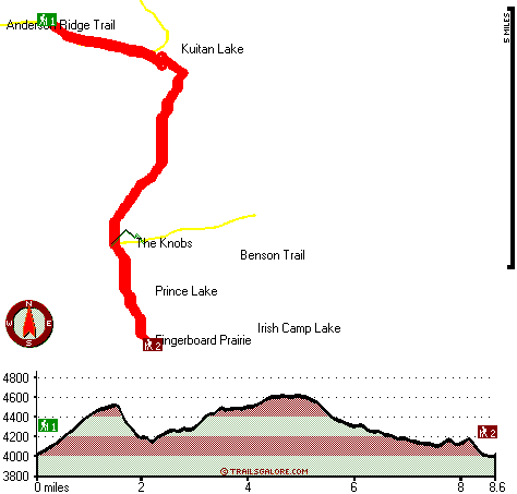
Trailhead 1 to Trailhead 2: Total hiking length = 8.6 miles Total climbing distance = 4.2 miles Difficulty : Difficult Casual Hiking Pace:
8 hours
Fast Hiking Pace:
4.5 hours
Trailhead 2 to Trailhead 1: Total hiking length = 8.6 miles Total climbing distance = 3.7 miles Difficulty : Difficult Casual Hiking Pace:
7.5 hours
Fast Hiking Pace:
4 hours
| | Trailhead 1 back to Trailhead 1: Total hiking length = 17.2 miles Total climbing distance = 7.9 miles Difficulty : Difficult Casual Hiking Pace:
2.5 days
Fast Hiking Pace:
1.5 days
Trailhead 2 back to Trailhead 2: Total hiking length = 17.2 miles Total climbing distance = 7.9 miles Difficulty : Difficult Casual Hiking Pace:
2.5 days
Fast Hiking Pace:
1.5 days
|
Total elevation difference: 814 feet

Lodge at Suttle Lake, Sisters
|
22 miles away
We are not your typical hotel. Nestled in the heart of the Deschutes National Forest amid soaring pines. Suttle Lake Resort provides an enchanted escape. Our resorts mountain views and pristine lake w...
|
| |
Best Western Ponderosa Lodge, Sisters
|
28 miles away
Offers a refreshing environment with renovated rooms, new deluxe suites and smoke-free accommodations. The perfect choice while traveling the 'Gateway to the Cascades', ideally located on 14 acres sur...
|
|
User input for Deer Butte Trail, Central Cascade Range, Linn County, Oregon:

Outdoors Recreation Near Bend, Oregon Very comprehensive list of a variety of outdoors recreation in the vicinity of Bend, Oregon, the metro area neareast to Deer Butte Trail. Find info on campgrounds, hiking trails, ski resorts, lakes, beaches, parks, whitewater and more.
More Hotels and Campgrounds Near Deer Butte Trail, Central Cascade Range, Linn County, Oregon
| |
| |
 |
|
| These outdoors activities are available near Deer Butte Trail. |
| | Trails Near Deer Butte Trail:
 |
Benson Trail, Lane County
County
, 2 miles away, 8.4 hiking miles, 1312 feet elevation difference |
 |
Anderson Ridge Trail, Linn County
County
, 3 miles away, 7.5 hiking miles, 2720 feet elevation difference |
 |
Hand Lake Trail, Lane County
County
, 5 miles away, 4 hiking miles, 224 feet elevation difference |
 |
Louise Creek Trail, Lane County
County
, 7 miles away, 19.8 hiking miles, 2731 feet elevation difference |
 |
Foley Ridge Trail, Lane County
County
, 7 miles away, 14.4 hiking miles, 2690 feet elevation difference |
 |
Smith Prairie Trail, Linn County
County
, 7 miles away, 8.6 hiking miles, 923 feet elevation difference |
 |
Patjens Lakes Trail, Linn County
County
, 8 miles away, 5.6 hiking miles, 480 feet elevation difference |
|
| | Whitewater Near Deer Butte Trail:
 |
Horse Creek, Lane County
County
, 11 miles away, Class III - 11 miles long (above Separation Creek to McKenzie River) |
 |
Marion Creek, Linn County
County
, 18 miles away, Class IV(V) - 7 miles long (Gooch Falls) |
 |
Blue River, Linn/ Lane County
County
, 19 miles away, Class IV-V - 4 miles long (Quentin Creek to Blue River Reservoir) |
 |
McKenzie River - South Fork, Lane County
County
, 20 miles away, Class III-IV - 6.2 miles long (Dutch Oven Camp to Cougar Reservoir) |
 |
Lookout Creek, -blank- County
County
, 20 miles away, Class III-IV - 2.5 miles long (2.5 miles above Blue River to Blue River) |
|
| | Hotels Near Deer Butte Trail:
 |
Lodge at Suttle Lake, Sisters
, 22 miles away |
 |
Best Western Ponderosa Lodge, Sisters
, 28 miles away |
 |
Five Pine Lodge, Sisters
, 29 miles away |
 |
Sunriver Resort, Sunriver
, 40 miles away |
 |
The Pines at Sunriver, Sunriver
, 40 miles away |
|
|
|
 |
|