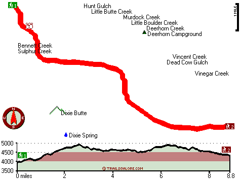
Oregon hiking trails - Davis Creek Trail, Blue Mountains, Grant County

   
  Every Oregon hiking trail is different from the others. Davis Creek Trail is very far from the most adjacent great urban center, and backcountry hiking is such a cool thing to do, and this is a magnificent place to do that. Trekking in Oregon is so much fun. Please follow all local rules about fires and camping. This region does get very dry sometimes, so make sure you check current conditions and fire restrictions with local forest authorities before you head out. Hiking and backpacking trails like this one here in the Blue Mountains are a really glorious
    way to spend quality time in the great outdoors. This great outdoors trail has two trailheads, so backcountry trekking it one way is an option if you can arrange for a ride back. You spend the whole trek in roughly the same elevation zone which means the conditions are about the
same from start to finish. Tremendous hiking trails in Oregon are in abundance, and one of those is Davis Creek Trail in Grant County. Summer at Davis Creek Trail comes with high temperatures in the 80's, and all through summer nights temperatures are in the 40's. For the duration of the wintertime the highs are commonly in the 40's while Davis Creek Trail nighttime low temperatures all through the wintertime are in the 20's. Oregon has lots of outdoors things to do. This is just one of a large number of hiking trails in this vicinity. This hiking and backpacking  
trail is many miles long having an average number of uphill miles which makes this hiking trail tremendous for hard core backpackers looking for adventure. The total elevation difference for this great outdoors trail is 1,328 feet, and that is about average. Now, this is roughly a 2.5-day walk, so it's a nice thing if your backpack is big enough to do the job. With its 17.6 miles of walking distance; it's a long great outdoors trail. This is a long hiking and backpacking trail, so make sure you bring plenty of supplies. It is very dehydrated here at Davis Creek Trail commonly; May is when you get the most rain here while July is commonly the driest month. When was the last time you got out in the fresh air a bit? Davis Creek Trail in Grant County, Oregon is the fresh air at its best.

Briefly about the general area:
Now, you may feel that's loads but there's even more amusing stuff to do here at Davis Creek Trail. There's so much to do here at Davis Creek Trail that you need to camp here for a while, Deerhorn Campground is a great location for that, and paddling on John Day River - North Fork is so much fun. Cow Camp Meadows is a stunning spot any time of year, and if you came to camp Looney Spring Campground is a fine site to do that.
This river is so great. It's always great to stop at Sunrise Spring, and while you're here, you could take a look at Little Boulder Creek. So many cool things to do in the Blue Mountains, not enough time. A quick journey to Murdock Creek near Davis Creek Trail is a good idea; a great site is Hunt Gulch. Places like Squatter Flat are nice to have a look at, and don't leave Davis Creek Trail without first paying a visit to Dixie Spring.
There's no way someone can get bored here in the Blue Mountains.

Location of Trailhead 1: Latitude 44.6368, Longitude -118.6485
- - Directions and Road Map

Location of Trailhead 2: Latitude 44.5746, Longitude -118.537
- - Directions and Road Map


Trailhead 1 to Trailhead 2:
Total hiking length = 8.8 miles
Total climbing distance = 4.3 miles
Difficulty : Difficult
Casual Hiking Pace: 8 hours
Fast Hiking Pace: 4.5 hours

Trailhead 2 to Trailhead 1:
Total hiking length = 8.8 miles
Total climbing distance = 3.9 miles
Difficulty : Difficult
Casual Hiking Pace: 8 hours
Fast Hiking Pace: 4.5 hours
    Trailhead 1 back to Trailhead 1:
Total hiking length = 17.6 miles
Total climbing distance = 8.2 miles
Difficulty : Difficult
Casual Hiking Pace: 2.5 days
Fast Hiking Pace: 2 days

Trailhead 2 back to Trailhead 2:
Total hiking length = 17.6 miles
Total climbing distance = 8.2 miles
Difficulty : Difficult
Casual Hiking Pace: 2.5 days
Fast Hiking Pace: 2 days

Total elevation difference: 1328 feet


Best Western John Day Inn, John Day
27 miles away
This charming John Day, Oregon hotel is minutes from a variety of outdoor activities and walking distance from many local shops and restaurants. Located in Eastern Oregon's beautiful John Day Valley...
  
User input for Davis Creek Trail, Blue Mountains, Grant County, Oregon:

Submit Input:
Your Name:
Write or Paste Input here:

Upload picture:      Review Guidelines


Outdoors Recreation Near La Grande, Oregon
Very comprehensive list of a variety of outdoors recreation in the vicinity of La Grande, Oregon, the metro area neareast to Davis Creek Trail. Find info on campgrounds, hiking trails, ski resorts, lakes, beaches, parks, whitewater and more.

Current weather conditions at Davis Creek Trail, Blue Mountains, Grant County, Oregon
WXPort

Local climate location: JOHN DAY 17 miles away


More Hotels and Campgrounds Near Davis Creek Trail, Blue Mountains, Grant County, Oregon

OTHER_INFO
  Blue Mountains Campgrounds
Complete list of all the campgrounds in the Blue Mountains.

Blue Mountains Outdoors Info
Complete outdoors info for the Blue Mountains.

Oregon Hiking Trails
Complete list of all hiking trails in Oregon

Books about hiking trails in Oregon
List of books available on Amazon.com about hiking trails in Oregon.

Oregon Outdoors Index
This is a very comprehensive index of outdoors activities in the great state of Oregon.


TOPO
High quality water resistant topo map of Davis Creek Trail, Blue Mountains, Grant County, Oregon.

OUTDOORS_GUIDE
These outdoors activities are available near Davis Creek Trail.
 Trails Near Davis Creek Trail:
Reynolds Creek Trail, Grant County County , 5 miles away, 1.6 hiking miles, 137 feet elevation difference
Lost Lake Trail, Grant County County , 8 miles away, 4.7 hiking miles, 1523 feet elevation difference
Princess Trail, Grant County County , 8 miles away, 6 hiking miles, 477 feet elevation difference
Big Boulder Trail, Grant County County , 8 miles away,  3.6 hiking miles, 1719 feet elevation difference
Ragged Rocks Trail, Grant County County , 9 miles away,  1.8 hiking miles, 673 feet elevation difference
Squaw Rock Trail, Grant County County , 10 miles away, 2.1 hiking miles, 540 feet elevation difference
Spruce Log Trail, Grant County County , 10 miles away, 1.4 hiking miles, 421 feet elevation difference
 Camp Grounds Near Davis Creek Trail:
Deerhorn Campground, Grant County, 1 miles away
Looney Spring Campground, Grant County, 14 miles away
Corrigal Spring Campground, Grant County, 17 miles away
Indian Springs Campground, Grant County, 18 miles away
 Whitewater Near Davis Creek Trail:
John Day River - North Fork, Grant/ Umatilla County County , 18 miles away, Class II-III - 41 miles long (Route 52 Bridge to Dale)
Grande Ronde River, Union County County , 33 miles away, Class II-IV - 17 miles long (Tony Vey Meadow to Red Bridge State Park)
 National Parks Near Davis Creek Trail:
John Day Fossil Beds National Monument, Kimberly - OR , 68 miles away
 Hotels Near Davis Creek Trail:
Sag's Motel, Prairie City , 9 miles away
Lodge At Granite, Sumpter , 16 miles away
Traveler's Motel, John Day , 26 miles away
Dreamers Lodge Motel, John Day , 26 miles away
Best Western John Day Inn, John Day , 27 miles away
 Lakes Near Davis Creek Trail
Bates Pond, Grant County , 6 miles away

Outdoors related information copyright © Stratus-Pikpuk, Inc. - Detailed hotel information copyright © Interactive Hotel Solutions