| |
The total elevation difference for this backcountry trail is 1,564 feet which is an average number. There are two trailheads to chose from, one in each end, so if you can get a ride from someone, you can hike it just one way. The time needed for this backcountry walk is roughly 4 hours, but of course some people walk a bit slower and some a bit faster. Different parts of Cottonwood Meadows Trail are at very different elevations which of course means you need to be prepared for different conditions on different parts of the backpacking trail. Being 5 miles long it's a mid length hike. Sometimes this wilderness trail gets really dry, so do check for current fire restrictions before you go if you plan to bring a stove or make a camp fire. Even though this is not a very long wilderness trail you should still bring some emergency supplies just in case something happens.
|
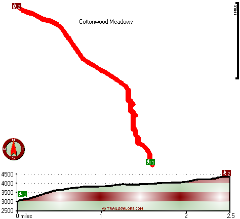
Trailhead 1 to Trailhead 2:
Total hiking length = 2.5 miles
Total climbing distance = 1.7 miles
Difficulty : Difficult
Casual Hiking Pace:
2.5 hours
Fast Hiking Pace:
1.5 hours
Trailhead 2 to Trailhead 1:
Total hiking length = 2.5 miles
Total climbing distance = 0 miles
Difficulty : Easy
Casual Hiking Pace:
1.5 hours
Fast Hiking Pace:
1 hours
| | Trailhead 1 back to Trailhead 1:
Total hiking length = 5 miles
Total climbing distance = 1.7 miles
Difficulty : Medium
Casual Hiking Pace:
4 hours
Fast Hiking Pace:
2.5 hours
Trailhead 2 back to Trailhead 2:
Total hiking length = 5 miles
Total climbing distance = 1.7 miles
Difficulty : Medium
Casual Hiking Pace:
4 hours
Fast Hiking Pace:
2.5 hours
|
Total elevation difference: 1564 feet
|


