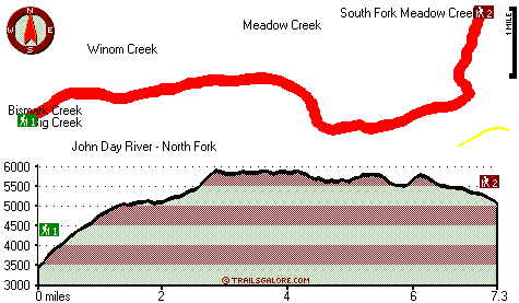
| |
|
| | Hitting the great outdoors hiking trails is always a fun thing to do, and Corral Creek Trail in Grant County, Oregon is a really great spot to spend some time. There are numerous trails in Oregon, and each one is worth backcountry trekking. As long as you like the great outdoors you will like Oregon. Backcountry hiking trails are great and plentiful in Oregon, and one of these is Corral Creek Trail in Grant County. Not much rain falls here at Corral Creek Trail; November is the month that gets the most rain; the driest month of the year is July. Corral |
|
Creek Trail has a total elevation difference of 2,646 feet which is higher than average. This is a long backcountry trail, so don't forget to pack enough supplies. When you're here in Oregon backcountry trekking along one of its trails never gets boring. This is a region covered
| | with lots of great outdoors hiking trails. This backpacking trail has two trailheads, so if you can get a ride from someone, you can hike it just one way. And keep in mind that there could be temporary safety restrictions in spot. With its 14.6 miles of walking distance; it's considered a longer backcountry trek. At Corral Creek Trail all through the months of summer highs are in the 80's. When the night sets in temperatures descend down into the 30's. Daytime highs through the wintertime are in the 30's while Corral Creek Trail night low temperatures through | |
|
the wintertime are in the 10's. This neighborhood does get very dry sometimes, so do check for current fire restrictions before you go if you plan to bring a stove or make a camp fire. Pretty far from Pendleton-Hermiston you come across Corral Creek Trail, but It's always cool
to backcountry trek here. This backpacking trail is many miles long having an average number of uphill miles which makes this a very tough great outdoors hiking trail for advanced hikers looking for an outstanding challenge. These backpacking trails here in the Blue Mountains are
a magnificent way to explore these mountaintops. Of course, this is an overnight hike, 2 days normally, so it's an outstanding thing if your backpack is big enough to do the job. Corral Creek Trail goes through some very different elevations, and that means that some parts of the
hiking trail could be very different from other parts of it.
Briefly about the general area: Do set aside some time for Big Creek Meadow while you're here at Corral Creek Trail, and since you're here, you could pop by Meadow Creek. Fitzwater Gulch is a delightful location
to stop at close by, and if you don't mind getting dripping wet, you can always go whitewater paddling on John Day River - North Fork. This place, Corral Creek Trail, it simply has so much outdoors cool stuff. If you came to camp Lehman Hot Springs is a fine place to do that;
don't leave Corral Creek Trail without first paying a visit to Lookout Spring. Life's too short to enjoy all the entertaining things in the Blue Mountains. Grande Ronde River has a brilliant whitewater paddling spot close by. All year is a good time in the Blue Mountains if you
have a thing about the outdoors. Don’t forget to stop by Winom Meadows while you're here at Corral Creek Trail It's always pleasant to stop by Handy Spring. Corral Creek Trail is tremendous enough to spend more than a day at, Trough Creek Campground is a tremendous local campground, and a quick visit to Cougar Creek is undeniably a good idea.
|
|
Location of Trailhead 1: Latitude 44.9611, Longitude -118.68 - - Directions and Road Map
Location of Trailhead 2: Latitude 44.983, Longitude -118.5871 - - Directions and Road Map

Trailhead 1 to Trailhead 2: Total hiking length = 7.3 miles Total climbing distance = 3.8 miles Difficulty : Difficult Casual Hiking Pace:
7 hours
Fast Hiking Pace:
4 hours
Trailhead 2 to Trailhead 1: Total hiking length = 7.3 miles Total climbing distance = 2.6 miles Difficulty : Difficult Casual Hiking Pace:
6 hours
Fast Hiking Pace:
3.5 hours
| | Trailhead 1 back to Trailhead 1: Total hiking length = 14.6 miles Total climbing distance = 6.4 miles Difficulty : Difficult Casual Hiking Pace:
2 days
Fast Hiking Pace:
8.5 hours
Trailhead 2 back to Trailhead 2: Total hiking length = 14.6 miles Total climbing distance = 6.4 miles Difficulty : Difficult Casual Hiking Pace:
2 days
Fast Hiking Pace:
8.5 hours
|
Total elevation difference: 2646 feet

|
| |
Best Western John Day Inn, John Day
|
35 miles away
This charming John Day, Oregon hotel is minutes from a variety of outdoor activities and walking distance from many local shops and restaurants. Located in Eastern Oregon's beautiful John Day Valley...
|
|
User input for Corral Creek Trail, Blue Mountains, Grant County, Oregon:

Outdoors Recreation Near Pendleton-Hermiston, Oregon Very comprehensive list of a variety of outdoors recreation in the vicinity of Pendleton-Hermiston, Oregon, the metro area neareast to Corral Creek Trail. Find info on campgrounds, hiking trails, ski resorts, lakes, beaches, parks, whitewater and more.
|
Current weather conditions at Corral Creek Trail, Blue Mountains, Grant County, Oregon

Local climate location: UKIAH 7 miles away

           
| |
Americas Best Value Inn, John Day
|
35 miles away
The Americas Best Value Inn is centrally located in the heart of John Day, Oregon. Our charming two story outside corridor facility offers 40 spacious guest rooms with a city view. We have a Mexican R...
|
Super 8 Pendleton, Pendleton
|
35 miles away
*Complimentary SuperStart Breakfast, indoor heated pool and whirlpool, free Wireless High Speed Internet, Direct TV - w/5 HBO, suites w/jacuzzi, micro-fridge, pets allowed w/permission ($10 non refund...
|
|
More Hotels and Campgrounds Near Corral Creek Trail, Blue Mountains, Grant County, Oregon
| |
| |
 |
|
| These outdoors activities are available near Corral Creek Trail. |
| | Trails Near Corral Creek Trail:
 |
Cougar Creek Trail, Grant County
County
, 3 miles away, 13 hiking miles, 2106 feet elevation difference |
 |
Glade Creek Trail, Grant County
County
, 4 miles away, 13.6 hiking miles, 2882 feet elevation difference |
 |
Cable Creek Trail, Umatilla County
County
, 5 miles away, 6.9 hiking miles, 1822 feet elevation difference |
 |
Basin Creek Trail, Grant County
County
, 5 miles away, 5.8 hiking miles, 622 feet elevation difference |
 |
Kelsay Butte Trail, Grant County
County
, 5 miles away, 7 hiking miles, 884 feet elevation difference |
 |
Indian Trail, Grant County
County
, 5 miles away, 6.7 hiking miles, 1314 feet elevation difference |
 |
Pearson Trail, Umatilla County
County
, 5 miles away, 5.5 hiking miles, 926 feet elevation difference |
|
| | Whitewater Near Corral Creek Trail:
 |
John Day River - North Fork, Grant/ Umatilla County
County
, 3 miles away, Class II-III - 41 miles long (Route 52 Bridge to Dale) |
 |
Grande Ronde River, Union County
County
, 22 miles away, Class II-IV - 17 miles long (Tony Vey Meadow to Red Bridge State Park) |
 |
Grande Ronde River, Union County
County
, 29 miles away, Class II - 8 miles long (Red Bridge State Park to Hilgard Junction State Park) |
|
| | Hotels Near Corral Creek Trail:
 |
Rugged Country Lodge DBA Double H Investments, Pendleton
, 32 miles away |
 |
Best Western John Day Inn, John Day
, 35 miles away |
 |
Americas Best Value Inn, John Day
, 35 miles away |
 |
Super 8 Pendleton, Pendleton
, 35 miles away |
 |
Best Western Pendleton Inn, Pendleton
, 35 miles away |
|
|
|
 |
|