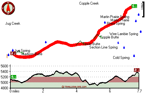
Oregon hiking trails - Copple Butte Trail, Blue Mountains, Morrow County

   
  Oregon is a nice spot for outdoors people. Trekking here in Oregon is so much fun. Copple Butte Trail is situated a quite long drive from Pendleton-Hermiston, but trekking it is always cool. Copple Butte Trail is quite long, so do pack enough food to last the whole trip. Copple Butte Trail is pretty waterless ordinarily; the month with most of the rain is November while July is ordinarily the driest month. Copple Butte Trail is a two ended hiking trail with two trailheads which means you have the option of backcountry trekking it one way if you have someone
    to pick you up at the other end. The backcountry trails of the Blue Mountains are a really perfect way to spend quality time in the wilderness. All through the warm months highs here at Copple Butte Trail reach the 80's. Summer overnight lows descend down to the 50's. The wintertime
comes with highs in the 40's, and overnight lows at Copple Butte Trail all through the wintertime mostly descend into the 20's. Sometimes this backcountry hiking trail gets really dry, so don’t forget to check for any current fire restrictions before you go. The hiking trail stays roughly within the same elevation zone the whole time, so you won’t have to worry about different climate zones along your backcountry walk. The total elevation difference for this hiking trail is 615 feet, and that is lower than average. Now, this is roughly a 2.5-day backcountry  
hike, so make sure you've got all your overnight gear packed. The number of backpacking and hiking trails in this vicinity is not very high. This backcountry trail is a backcountry trail of perfect length with an average amount of climbing distance which makes it a magnificent backpacking and hiking trail for experienced backcountry hikers in good shape. Delightful wilderness hiking trails in Oregon are in abundance; one of them being Copple Butte Trail in Morrow County. Hey, time for a backcountry hike don’t you think? Copple Butte Trail in Morrow County, Oregon is just what you need. Copple Butte Trail is 15.4 miles long; it's a long hiking trail. Don’t forget to check for any current restrictions or closures before you go. Every wilderness hiking trail in Oregon is scenic in its own way.

Briefly about the general area:
Martin Prairie is right here at Copple Butte Trail, and a short trip to Mud Spring is always worthwhile. Yeah, come here to Copple Butte Trail for a brilliant time. Rhea Spring is an inspiring place to explore while here.
So much amusing stuff to do here in the Blue Mountains, too perfect to be true. Don't forget to take a tremendous little visit to Copple Creek; John Day River - North Fork is a great whitewater spot nearby. A fine place like Rasmuss Meadow here at Copple Butte Trail is too fine to miss. There's so much to do here at Copple Butte Trail that you need to camp here for a while, Elkhorn Tavern and RV Park is a good place for that. It's a nice idea to visit East Fork Alder Creek, it's in the vicinity of Copple Butte Trail, and Copple Butte Trail is right next door to Hunt Canyon which is without doubt worth stopping at.

Location of Trailhead 1: Latitude 45.1503, Longitude -119.369
- - Directions and Road Map

Location of Trailhead 2: Latitude 45.107, Longitude -119.4798
- - Directions and Road Map


Trailhead 1 to Trailhead 2:
Total hiking length = 7.7 miles
Total climbing distance = 4.2 miles
Difficulty : Difficult
Casual Hiking Pace: 7.5 hours
Fast Hiking Pace: 4 hours

Trailhead 2 to Trailhead 1:
Total hiking length = 7.7 miles
Total climbing distance = 3.2 miles
Difficulty : Difficult
Casual Hiking Pace: 7 hours
Fast Hiking Pace: 3.5 hours
    Trailhead 1 back to Trailhead 1:
Total hiking length = 15.4 miles
Total climbing distance = 7.4 miles
Difficulty : Difficult
Casual Hiking Pace: 2.5 days
Fast Hiking Pace: 1.5 days

Trailhead 2 back to Trailhead 2:
Total hiking length = 15.4 miles
Total climbing distance = 7.4 miles
Difficulty : Difficult
Casual Hiking Pace: 2.5 days
Fast Hiking Pace: 1.5 days

Total elevation difference: 615 feet


Comfort Inn & Suites, Hermiston
33 miles away
Hermiston, where East/West meets North/South, with easy access to Seattle, Portland, Boise, and Salt Lake. The hotel is located on the interstate. Just a short trip to downtown or the Umatilla area. W...
  
Best Western Hermiston Inn, Hermiston
36 miles away
Enjoy convenient access to Wal-Mart Distribution Center and the Pendleton Roundup while staying at this Hermiston, Oregon hotel. Welcome to the Best Western Hermiston Inn where guests will receive t...
User input for Copple Butte Trail, Blue Mountains, Morrow County, Oregon:

Submit Input:
Your Name:
Write or Paste Input here:

Upload picture:      Review Guidelines


Outdoors Recreation Near Pendleton-Hermiston, Oregon
Very comprehensive list of a variety of outdoors recreation in the vicinity of Pendleton-Hermiston, Oregon, the metro area neareast to Copple Butte Trail. Find info on campgrounds, hiking trails, ski resorts, lakes, beaches, parks, whitewater and more.

Current weather conditions at Copple Butte Trail, Blue Mountains, Morrow County, Oregon
WXPort

Local climate location: HEPPNER 8 miles away

Oak Tree Inn Hermiston, Hermiston
36 miles away
With extra-quiet guest rooms and light-proof draperies the Oak Tree Inn Hermiston is a 100-percent non-smoking hotel offering a fitness center, spa, and comfortable, nicely decorated rooms with reclin...

Oxford Suites Hermiston, Hermiston
36 miles away
The Oxford Suites Hermiston provides lodging in Hermiston near McNary Lock and Dam and the beautiful Columbia River. We are also convenient to area businesses such as Simplot Umatilla Army Depot Union...

More Hotels and Campgrounds Near Copple Butte Trail, Blue Mountains, Morrow County, Oregon

OTHER_INFO
  Blue Mountains Campgrounds
Complete list of all the campgrounds in the Blue Mountains.

Blue Mountains Outdoors Info
Complete outdoors info for the Blue Mountains.

Oregon Hiking Trails
Complete list of all hiking trails in Oregon

Books about hiking trails in Oregon
List of books available on Amazon.com about hiking trails in Oregon.

Oregon Outdoors Index
This is a very comprehensive index of outdoors activities in the great state of Oregon.


TOPO
High quality water resistant topo map of Copple Butte Trail, Blue Mountains, Morrow County, Oregon.

OUTDOORS_GUIDE
These outdoors activities are available near Copple Butte Trail.
 Trails Near Copple Butte Trail:
Madison Butte Trail, Morrow County County , 5 miles away, 3 hiking miles, 894 feet elevation difference
Minetop Trail, Morrow County County , 7 miles away,  6 hiking miles, 931 feet elevation difference
Section Line Trail, Morrow County County , 12 miles away, 2.9 hiking miles, 570 feet elevation difference
 Camp Grounds Near Copple Butte Trail:
Elkhorn Tavern and RV Park, Monument, 13 miles away
 Whitewater Near Copple Butte Trail:
John Day River - North Fork, Grant County County , 20 miles away, Class II - 44 miles long (Dale to Monument)
 National Parks Near Copple Butte Trail:
John Day Fossil Beds National Monument, Kimberly - OR , 24 miles away
 Hotels Near Copple Butte Trail:
Comfort Inn & Suites, Hermiston , 33 miles away
Best Western Hermiston Inn, Hermiston , 36 miles away
Oak Tree Inn Hermiston, Hermiston , 36 miles away
Oxford Suites Hermiston, Hermiston , 36 miles away
Tillicum Inn, Umatilla , 39 miles away

Outdoors related information copyright © Stratus-Pikpuk, Inc. - Detailed hotel information copyright © Interactive Hotel Solutions