Oregon hiking trails - Copeland Creek Trail, Central Cascade Range, Douglas County

   
  In Oregon you never run out of outdoors fun. Every Oregon trail is well worth a trek. Oregon has plenty of nice trails, and Copeland Creek Trail in Douglas County is one of them. This neighborhood does get very dry sometimes, so don’t forget to check for any current fire restrictions before you go. Summertime brings highs in the 80's to Copeland Creek Trail, and during the night it cools down to the 40's. The winter brings highs down to the 40's, and after the sun is down during the winter temperatures at Copeland Creek Trail fall into the 30's. This backcountry
    hiking trail is a normal length backcountry hiking trail with an average amount of climbing distance which makes this a very tough great outdoors trail for advanced trekkers looking for a fine challenge. Different parts of this backcountry hiking trail are at very different elevations,
so keep in mind that you may need to dress differently at different elevations. With its 6.2 miles of walking distance it's a mid length trek. This is one of many great outdoors trails in the surrounding region. This trek shouldn't take more than 5.5 hours, but of course some folks walk a bit slower and some a bit faster. A lengthy tour divides Medford from Copeland Creek Trail, but what a great place for trekking it is. We all need to get out in nature once in a while, and Copeland Creek Trail in Douglas County, Oregon is a great choice. Going for a trek  
here in Oregon is a brilliant way to spend some time. Don’t forget to check for any current restrictions or closures before you go. Copeland Creek Trail has two trailheads, so backcountry hiking it one way is an option if you can arrange for a ride back. The gorgeous backcountry hiking trails of the Central Cascade Range are a very magnificent way to see these highlands. Copeland Creek Trail has a total elevation difference of 3,234 feet which is higher than average. This is a hiking and backpacking trail that is quite long, so don't forget to pack enough supplies. All the water falling down from the sky makes Copeland Creek Trail a wet place; during November this area sees the most rain; the driest of the months is July.

Briefly about the general area:
Bear Wallow is a good place to check out; why not a little side trip to Bow Creek. Why not camp at Big Twin Lakes Campground if you're here at Copeland Creek Trail; you can run the rapids of Steamboat Creek.
You absolutely must like the Central Cascade Range. Buckhead Mountain Campground is a good local campground; get your pulse rate up on the fine whitewater of Copland Creek.

Location of Trailhead 1: Latitude 43.2119, Longitude -122.5474
- - Directions and Road Map

Location of Trailhead 2: Latitude 43.1893, Longitude -122.5837
- - Directions and Road Map


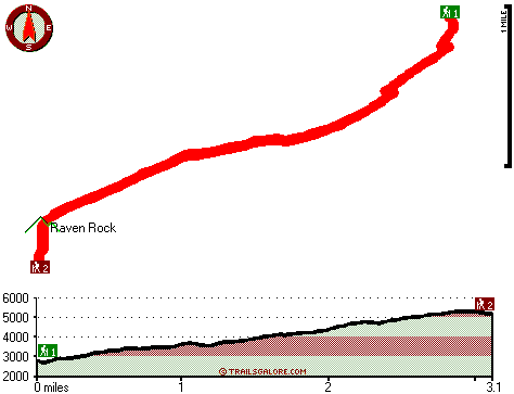
Trailhead 1 to Trailhead 2:
Total hiking length = 3.1 miles
Total climbing distance = 2 miles
Difficulty : Medium
Casual Hiking Pace: 3 hours
Fast Hiking Pace: 2 hours

Trailhead 2 to Trailhead 1:
Total hiking length = 3.1 miles
Total climbing distance = .4 miles
Difficulty : Easy
Casual Hiking Pace: 2 hours
Fast Hiking Pace: 1 hours
    Trailhead 1 back to Trailhead 1:
Total hiking length = 6.2 miles
Total climbing distance = 2.4 miles
Difficulty : Difficult
Casual Hiking Pace: 5.5 hours
Fast Hiking Pace: 3.5 hours

Trailhead 2 back to Trailhead 2:
Total hiking length = 6.2 miles
Total climbing distance = 2.4 miles
Difficulty : Difficult
Casual Hiking Pace: 5.5 hours
Fast Hiking Pace: 3.5 hours

Total elevation difference: 3234 feet


Best Western Oakridge Inn, Oakridge
28 miles away
This Oakridge, Oregon hotel offers a complimentary continental breakfast each morning and convenient access to a variety of outdoor activities. Discover the Best Western Oakridge Inn, nestled agains...
  
La Quinta Inn and Suites White City, White City
44 miles away
The new La Quinta Inn & Suites White City, near Medford, the gateway to Crater Lake National Park, provides spacious, modern rooms with amenities that include microwave, refrigerator, free high-speed ...
User input for Copeland Creek Trail, Central Cascade Range, Douglas County, Oregon:

Submit Input:
Your Name:
Write or Paste Input here:

Upload picture:      Review Guidelines


Outdoors Recreation Near Medford, Oregon
Very comprehensive list of a variety of outdoors recreation in the vicinity of Medford, Oregon, the metro area neareast to Copeland Creek Trail. Find info on campgrounds, hiking trails, ski resorts, lakes, beaches, parks, whitewater and more.

Current weather conditions at Copeland Creek Trail, Central Cascade Range, Douglas County, Oregon
WXPort

Local climate location: IDLEYLD PARK 1 miles away

Moonstone Village Green Resort, Cottage Grove
45 miles away
Village Green Resort is located off Interstate 5, in Cottage Grove. The resort is six miles from the covered bridges, and approximately 30 miles from Eugene Airport. We are less than a mile from two g...

Comfort Inn Cottage Grove, Cottage Grove
45 miles away

More Hotels and Campgrounds Near Copeland Creek Trail, Central Cascade Range, Douglas County, Oregon

OTHER_INFO
  Central Cascade Range Campgrounds
Complete list of all the campgrounds in the Central Cascade Range.

Central Cascade Range Outdoors Info
Complete outdoors info for the Central Cascade Range.

Oregon Hiking Trails
Complete list of all hiking trails in Oregon

Books about hiking trails in Oregon
List of books available on Amazon.com about hiking trails in Oregon.

Oregon Outdoors Index
This is a very comprehensive index of outdoors activities in the great state of Oregon.


TOPO
High quality water resistant topo map of Copeland Creek Trail, Central Cascade Range, Douglas County, Oregon.

OUTDOORS_GUIDE
These outdoors activities are available near Copeland Creek Trail.
 Trails Near Copeland Creek Trail:
BVD Trail, Douglas County County , 1 miles away,  6.4 hiking miles, 2801 feet elevation difference
Twin Lakes Trail, Douglas County County , 3 miles away, 11.2 hiking miles, 4061 feet elevation difference
Deception Way, Douglas County County , 4 miles away,  6 hiking miles, 1482 feet elevation difference
Black Rock Trail, Douglas County County , 5 miles away, 2 hiking miles, 926 feet elevation difference
Spring Mountain Way, Douglas County County , 7 miles away, 6.4 hiking miles, 4292 feet elevation difference
 Camp Grounds Near Copeland Creek Trail:
Big Twin Lakes Campground, Douglas County, 2 miles away
Buckhead Mountain Campground, Douglas County, 4 miles away
Weeping Rock Campground, Douglas County, 5 miles away
River View RV Park, Idleyld Park, 6 miles away
Buckeye Lake Campground, Douglas County, 7 miles away
 Whitewater Near Copeland Creek Trail:
Copland Creek, Douglas County County , 4 miles away, Class IV(V) - 5.7 miles long (Second Bridge to North Umpqua)
Steamboat Creek, Douglas County County , 11 miles away, Class II+(IV) - 9.5 miles long (City Creek to Steamboat Falls)
Jackson Creek, Douglas County County , 11 miles away, Class IV(V) - 8 miles long (NF300 to Cover Camp)
Steamboat Creek, Douglas County County , 12 miles away, Class IV - 6 miles long (Steamboat Falls to Canton Creek Campground)
Umpqua River - North, Douglas County County , 14 miles away, Class III - 25.5 miles long (Soda Springs to Deadline Falls)
 National Parks Near Copeland Creek Trail:
Crater Lake National Park, Crater Lake - OR , 34 miles away
 Hotels Near Copeland Creek Trail:
Best Western Oakridge Inn, Oakridge , 28 miles away
La Quinta Inn and Suites White City, White City , 44 miles away
Moonstone Village Green Resort, Cottage Grove , 45 miles away
Comfort Inn Cottage Grove, Cottage Grove , 45 miles away
Holiday Inn Express COTTAGE GROVE, Cottage Grove , 45 miles away

Outdoors related information copyright © Stratus-Pikpuk, Inc. - Detailed hotel information copyright © Interactive Hotel Solutions