Oregon hiking trails - Cinder Prairie Way, Central Cascade Range, Douglas County

   
  Each one of the many backcountry hiking trails of Oregon is different from the others. Backcountry backpacking in Oregon is such a magnificent thing to do. We all need to get out in the great outdoors once in a while, and Cinder Prairie Way in Douglas County, Oregon is a glorious selection. This wilderness hiking trail has only one trailhead, so in and out is the way to trek it normally. Now this wilderness hiking trail is pretty long, so don't forget to pack enough supplies. Cinder Prairie Way is 10 miles long; it's longer than many wilderness hiking trails.
    This wilderness hiking trail sometimes gets very dry, so do check for current fire restrictions before you go if you plan to bring a stove or make a camp fire. High temperatures at Cinder Prairie Way through the warm months are in the 80's; through summer nights temperatures are
in the 50's. The winter comes with highs in the 40's while the cold winter nights at Cinder Prairie Way are in the 30's. Backcountry backpacking in Oregon is a glorious way to spend some time. The length of this wilderness hiking trail is on the longer side with an average amount of climbing distance which makes this hiking and backpacking trail good for hard core backpackers looking for adventure. Please follow all local rules about fires and camping. Cinder Prairie Way mostly gets a good deal of precipitation; all through November this region sees the  
most rain, and July is when it's the driest. This is one of many hiking and backpacking trails in the surrounding neighborhood. Cinder Prairie Way is relatively isolated from the closest town, and it's one of those spots where backcountry hiking is great. You should count on this backcountry walk taking about 8.5 hours, but of course some folks walk a bit slower and some a bit faster. The gorgeous wilderness hiking trails of the Central Cascade Range are the best way to enjoy these mountaintops. This wilderness hiking trail goes through some very different elevations which of course means you need to be prepared for different conditions on different parts of the wilderness hiking trail. There are backcountry hiking trails all over Oregon, and among these are Cinder Prairie Way in Douglas County. Cinder Prairie Way has a total elevation difference of 3,151 feet which is higher than average.

Briefly about the general area:
Soar down the rapids of Steamboat Creek in a kayak; why not camp at Slim Chance Campground if you're here at Cinder Prairie Way. Cinder Prairie Way beyond doubt is in the middle of a beautiful outdoors paradise. Spring Creek is a glorious spot to take a look at.
Picture Rock Prairie is a good place, and do put some time aside to spend at Soda Springs while you're here at Cinder Prairie Way. And if that's not enough there's plenty more cool stuff to do in the Central Cascade Range. Visit Slide Creek while you're here at Cinder Prairie Way, and locations like Bulldog Prairie are glorious to have a look at. If you come to this river you will have a good time for sure. Get wet paddling on Copland Creek, and a perfect place to camp here at Cinder Prairie Way is Camas Creek Campground.

Location of Trailhead: Latitude 43.354, Longitude -122.4243
- - Directions and Road Map

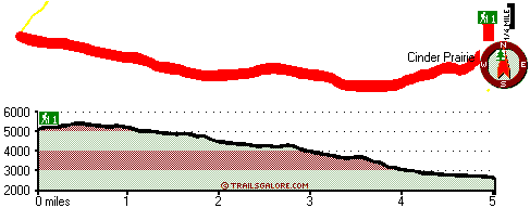
Total in and out hiking length = 10 miles

Total climbing distance = 4 miles

Difficulty : Difficult

Casual Hiking Pace: 8.5 hours

Fast Hiking Pace: 5.5 hours

Total elevation difference: 3151 feet


Best Western Oakridge Inn, Oakridge
20 miles away
This Oakridge, Oregon hotel offers a complimentary continental breakfast each morning and convenient access to a variety of outdoor activities. Discover the Best Western Oakridge Inn, nestled agains...
  
Moonstone Village Green Resort, Cottage Grove
46 miles away
Village Green Resort is located off Interstate 5, in Cottage Grove. The resort is six miles from the covered bridges, and approximately 30 miles from Eugene Airport. We are less than a mile from two g...
User input for Cinder Prairie Way, Central Cascade Range, Douglas County, Oregon:

Submit Input:
Your Name:
Write or Paste Input here:

Upload picture:      Review Guidelines


Outdoors Recreation Near Medford, Oregon
Very comprehensive list of a variety of outdoors recreation in the vicinity of Medford, Oregon, the metro area neareast to Cinder Prairie Way. Find info on campgrounds, hiking trails, ski resorts, lakes, beaches, parks, whitewater and more.

Current weather conditions at Cinder Prairie Way, Central Cascade Range, Douglas County, Oregon
WXPort

Local climate location: LOOKOUT POINT DAM 10 miles away

Comfort Inn Cottage Grove, Cottage Grove
47 miles away
Pet accommodation: 10.00/night....

Holiday Inn Express Cottage Grove, Or, Cottage Grove
47 miles away
Welcome to the Holiday Inn Express in Cottage Grove.We are conveniently located in the Willamette Valley 30 miles south of Eugene just off I-5 at exit 174.We offer a free Continental Breakfast, an ind...

More Hotels and Campgrounds Near Cinder Prairie Way, Central Cascade Range, Douglas County, Oregon

OTHER_INFO
  Central Cascade Range Campgrounds
Complete list of all the campgrounds in the Central Cascade Range.

Central Cascade Range Outdoors Info
Complete outdoors info for the Central Cascade Range.

Oregon Hiking Trails
Complete list of all hiking trails in Oregon

Books about hiking trails in Oregon
List of books available on Amazon.com about hiking trails in Oregon.

Oregon Outdoors Index
This is a very comprehensive index of outdoors activities in the great state of Oregon.


TOPO
High quality water resistant topo map of Cinder Prairie Way, Central Cascade Range, Douglas County, Oregon.

OUTDOORS_GUIDE
These outdoors activities are available near Cinder Prairie Way.
 Trails Near Cinder Prairie Way:
Perry Butte Way, Douglas County County , 1 miles away, 4.5 hiking miles, 1801 feet elevation difference
Boulder Creek Trail, Douglas County County , 2 miles away,  7.2 hiking miles, 3222 feet elevation difference
Bradley Trail, Douglas County County , 3 miles away, 5.2 hiking miles, 1195 feet elevation difference
Bristow Trail, Douglas County County , 4 miles away, 5.5 hiking miles, 1267 feet elevation difference
Mountain Meadows Trail, Douglas County County , 5 miles away, 2.2 hiking miles, 1752 feet elevation difference
Spring Mountain Way, Douglas County County , 5 miles away, 6.4 hiking miles, 4292 feet elevation difference
Grassy Ranch Trail, Douglas County County , 5 miles away, 3.5 hiking miles, 684 feet elevation difference
 Camp Grounds Near Cinder Prairie Way:
Camas Creek Campground, Douglas County, 6 miles away
Slim Chance Campground, Douglas County, 8 miles away
Weeping Rock Campground, Douglas County, 8 miles away
River View RV Park, Idleyld Park, 11 miles away
Big Twin Lakes Campground, Douglas County, 11 miles away
 Whitewater Near Cinder Prairie Way:
Copland Creek, Douglas County County , 6 miles away, Class IV(V) - 5.7 miles long (Second Bridge to North Umpqua)
Steamboat Creek, Douglas County County , 13 miles away, Class II+(IV) - 9.5 miles long (City Creek to Steamboat Falls)
Steamboat Creek, Douglas County County , 16 miles away, Class IV - 6 miles long (Steamboat Falls to Canton Creek Campground)
Hills Creek, Lane County County , 18 miles away, Class IV - 6 miles long (6 mi above Reservoir)
Brice Creek, Lane County County , 18 miles away, Class IV-V - 4.5 miles long (Parker Falls to Champion Creek)
 National Parks Near Cinder Prairie Way:
Crater Lake National Park, Crater Lake - OR , 32 miles away
 Hotels Near Cinder Prairie Way:
Steamboat Inn, Idleyld Park , 19 miles away
Arbor Inn, Oakridge , 20 miles away
Oakridge Motel, Oakridge , 20 miles away
Cascade Motel & Storage, Oakridge , 20 miles away
Best Western Oakridge Inn, Oakridge , 20 miles away
 Lakes Near Cinder Prairie Way
Skipper Lakes, Douglas County , 2 miles away
Loletta Lakes, Douglas County , 3 miles away

Outdoors related information copyright © Stratus-Pikpuk, Inc. - Detailed hotel information copyright © Interactive Hotel Solutions