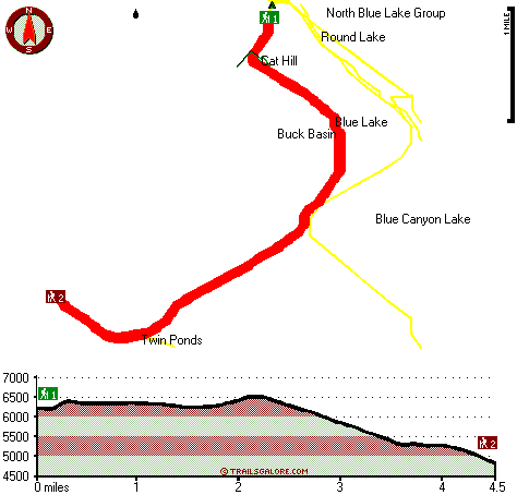
| |
|
| | Pretty far from Medford you come upon Cat Hill Way, but when you spend some time trekking here you will feel like a whole new person. Going for a walk here in Oregon is a great way to spend some time. Oregon is an outstanding place for walkers. Ok, you've been cooped up too long, time to get out in nature a bit, and Cat Hill Way in Jackson County, Oregon is an outstanding pick. Cat Hill Way is 9 miles long it's a mid length backcountry trek. Cat Hill Way is a two ended backcountry hiking trail with two trailheads, so backcountry trekking it one way is an |
|
option if you can arrange for a ride back. Every Oregon backcountry trail is different from the others. Summertime highs at Cat Hill Way generally tend to be in the 80's. Through the dark hours of summer temperatures plunge down into the 40's. Through the winter highs are in the
| | 40's with winter lows in the 20's overnight here at Cat Hill Way. At parts of the year this neighborhood sees very little rain, so make sure you check current conditions and fire restrictions with local forest authorities before you head out. The total elevation difference for this backcountry hiking trail is 2,014 feet, and that is about average. This backpacking and hiking trail goes through some very different elevations, and that means that some parts of the backpacking and hiking trail could be very different from other parts of it. Cat Hill Way | |
|
is quite long, so do pack enough food to last the whole trip. Please follow all local rules about fires and camping. You should count on this backcountry hike taking about 7.5 hours, but of course some folks walk a bit slower and some a bit faster. This great outdoors hiking trail
is a mid length great outdoors hiking trail with an average amount of climbing distance which makes this trail glorious for hard core backpackers looking for adventure. A common amount of precipitation falls here at Cat Hill Way; November is the wettest month with most rain; the
driest of the months is July. This is an area covered with lots of trails. Backcountry trekking here in the Southern Cascade Range is the best way to enjoy these mountains. Backpacking and hiking trails are nice and plentiful in Oregon; one of those is Cat Hill Way in Jackson County.
Briefly
about the general area: These mountains rock, just explore all the fun things to do in the Southern Cascade Range. McKee Basin is a fine spot here at Cat Hill Way; a quick tour to Gypsy Fork is beyond doubt a good idea. Upper South Fork Campground is a great campground here,
and don't leave Cat Hill Way without first paying a visit to Misfit Spring. A spree to Crater Lake National Park is worthwhile, and unsurprisingly Swan Creek flows through this area. Buck Basin is right here at Cat Hill Way, and the beauty of mother nature reveals herself at
Gypsy Spring. You absolutely have to go for Cat Hill Way. You can run the rapids of Rogue River - North Fork close to Cat Hill Way, and camping at Cat Hill Way is pleasant fun, Saddle Campground is a pleasant local campground. You definitely ought to like the Southern Cascade Range.
|
|
Location of Trailhead 1: Latitude 42.529, Longitude -122.2963 - - Directions and Road Map
Location of Trailhead 2: Latitude 42.4943, Longitude -122.3229 - - Directions and Road Map

Trailhead 1 to Trailhead 2: Total hiking length = 4.5 miles Total climbing distance = .7 miles Difficulty : Easy Casual Hiking Pace:
3 hours
Fast Hiking Pace:
1.5 hours
Trailhead 2 to Trailhead 1: Total hiking length = 4.5 miles Total climbing distance = 2.5 miles Difficulty : Medium Casual Hiking Pace:
4.5 hours
Fast Hiking Pace:
2.5 hours
| | Trailhead 1 back to Trailhead 1: Total hiking length = 9 miles Total climbing distance = 3.2 miles Difficulty : Difficult Casual Hiking Pace:
7.5 hours
Fast Hiking Pace:
5 hours
Trailhead 2 back to Trailhead 2: Total hiking length = 9 miles Total climbing distance = 3.2 miles Difficulty : Difficult Casual Hiking Pace:
7.5 hours
Fast Hiking Pace:
5 hours
|
Total elevation difference: 2014 feet

Lithia Springs Resort And Gardens, Ashland
|
24 miles away
Hello, from Ashland, Oregon! Imagine, at the end of a long day's travel, relaxing in a 2 person whirlpool filled with hot mineral water, right in your own room. Lay back, Let the relaxing quality of t...
|
| |
Windmill Inn And Suites Of Ashland, Ashland
|
30 miles away
The resort offers all the amenities of a big city hotel with the warm feeling of a country inn. All of the guest rooms are comfortable and nicely equipped to create a relaxing atmosphere. The hotel fe...
|
|
User input for Cat Hill Way, Southern Cascade Range, Jackson County, Oregon:

Outdoors Recreation Near Medford, Oregon Very comprehensive list of a variety of outdoors recreation in the vicinity of Medford, Oregon, the metro area neareast to Cat Hill Way. Find info on campgrounds, hiking trails, ski resorts, lakes, beaches, parks, whitewater and more.
|
Current weather conditions at Cat Hill Way, Southern Cascade Range, Jackson County, Oregon

Local climate location: PROSPECT 3 miles away

           
| |
Ashland Super 8 Motel, Ashland
|
30 miles away
Super 8 Motel Ashland, Oregon is AAA Approved, 2 Diamonds, convenient to I-5 adjacent Exit 14. We Have Wireless High Speed Internet, An Indoor Heated Pool, SuperStart breakfast, Micro-Fridges, Cable ...
|
|
More Hotels and Campgrounds Near Cat Hill Way, Southern Cascade Range, Jackson County, Oregon
| |
| |
 |
|
| These outdoors activities are available near Cat Hill Way. |
| | Trails Near Cat Hill Way:
 |
Twin Ponds Trail, Klamath County
County
, 2 miles away, 5.1 hiking miles, 1377 feet elevation difference |
 |
Blue Rock Trail, Klamath County
County
, 2 miles away, 7.6 hiking miles, 925 feet elevation difference |
 |
South Fork Trail, Klamath County
County
, 2 miles away, 7.4 hiking miles, 1813 feet elevation difference |
 |
Crater Trail, Jackson County
County
, 2 miles away, 4.4 hiking miles, 2571 feet elevation difference |
 |
Blue Canyon Trail, Klamath County
County
, 3 miles away, 10 hiking miles, 763 feet elevation difference |
 |
Goss Trail, Jackson County
County
, 5 miles away, 1.9 hiking miles, 680 feet elevation difference |
 |
Red Lake Trail, Klamath County
County
, 5 miles away, 10.3 hiking miles, 1759 feet elevation difference |
|
| | Whitewater Near Cat Hill Way:
 |
Rogue River - North Fork, Jackson County
County
, 19 miles away, Class IV(V+) - 3.3 miles long (Mill Creek Falls to Lost Creek Lake) |
 |
Rogue River - North Fork, Jackson County
County
, 19 miles away, Class III - 6 miles long (River Bridge to North Fork Park) |
|
| | Hotels Near Cat Hill Way:
 |
Lithia Springs Resort And Gardens, Ashland
, 24 miles away |
 |
Windmill Inn And Suites Of Ashland, Ashland
, 30 miles away |
 |
Holiday Inn Express Hotel & Suites Ashland, Or, Ashland
, 30 miles away |
 |
Ashland Super 8 Motel, Ashland
, 30 miles away |
 |
Ashland Springs Hotel, Ashland
, 32 miles away |
|
|
|
 |
|