Oregon hiking trails - Calapooya Trail, Central Cascade Range, Douglas County

   
  Hitting the backcountry hiking trails is always an exciting thing to do, and Calapooya Trail in Douglas County, Oregon is a really fine spot to spend some time. Hiking in Oregon is such a splendid thing to do. Every single Oregon wilderness hiking trail is well worth a walk. This hike shouldn't take more than 5.5 hours, but of course some folks walk a bit slower and some a bit faster. This hiking trail has two trailheads which means you have the option of backcountry hiking it one way if you have someone to pick you up at the other end. This is a long wilderness
    hiking trail, so do pack enough food to last the whole trip. All through the months of summer highs here at Calapooya Trail reach the 80's; the nighttime is a bit cooler of course, typically in the 40's. Daytime highs during the wintertime are in the 40's; winter nights come with
lows in the 20's to Calapooya Trail. Different parts of Calapooya Trail are at very different elevations, and that means that some parts of the backpacking and hiking trail could be very different from other parts of it. Here in the brilliant state of Oregon backcountry trekking never gets boring. The high level of precipitation makes Calapooya Trail a relatively wet spot; the month with most of the rain is December while July is generally the driest month. Calapooya Trail is a normal length hiking and backpacking trail with an average amount of climbing  
distance which makes this great outdoors trail nice for hard core backpackers looking for adventure. Don’t forget to check for any current restrictions or closures before you go. There are so many great outdoors trails in this area. Being 6.6 miles long it's an average length backpacking and hiking trail. This wilderness hiking trail sometimes gets very dry, so do check for current fire restrictions before you go if you plan to bring a stove or make a camp fire. The striking hiking and backpacking trails of the Central Cascade Range are the best way to enjoy these mountaintops. There are many brilliant wilderness hiking trails in Oregon; Calapooya Trail in Douglas County is one of them. Far from civilization you come across Calapooya Trail, and it is a really fine backcountry hiking trail. This hiking trail has a total elevation difference of 1,869 feet which is about average.

Briefly about the general area:
But wait, there's more exciting stuff to do in the Central Cascade Range. A delightful spot like Thorn Prairie here at Calapooya Trail is too wonderful to miss, and since you're here, you could take a look at Charlie Creek.
A nice location to camp here at Calapooya Trail is Slim Chance Campground, and paddling on Hills Creek is so much fun. Having a good time in the Central Cascade Range is simple. Upper Mountain Meadows is a splendid place here at Calapooya Trail, and whitewater paddling is perfect on Copland Creek. Man, is there a load of amusing things to do in close proximity to Calapooya Trail. Calapooya Trail is good enough to spend more than a day at, Camas Creek Campground is a good local campground, and a quick journey to Karen Creek is absolutely a great idea.
Deer Creek Diversion Dam has great water scenery and it's close to Calapooya Trail, and Umpqua Hot Springs is a fine local attraction.

Location of Trailhead 1: Latitude 43.3391, Longitude -122.3453
- - Directions and Road Map

Location of Trailhead 2: Latitude 43.358, Longitude -122.3561
- - Directions and Road Map


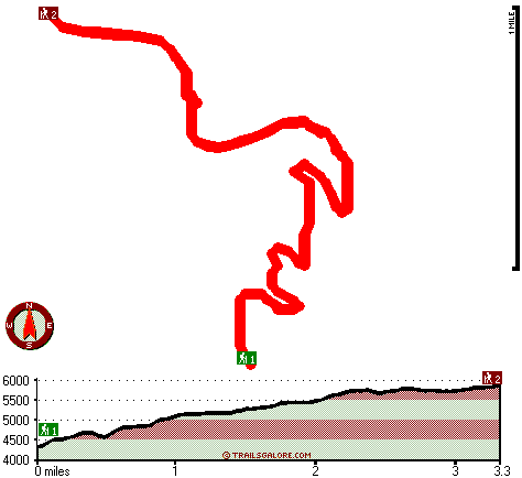
Trailhead 1 to Trailhead 2:
Total hiking length = 3.3 miles
Total climbing distance = 2.2 miles
Difficulty : Difficult
Casual Hiking Pace: 3.5 hours
Fast Hiking Pace: 2 hours

Trailhead 2 to Trailhead 1:
Total hiking length = 3.3 miles
Total climbing distance = .4 miles
Difficulty : Easy
Casual Hiking Pace: 2.5 hours
Fast Hiking Pace: 1 hours
    Trailhead 1 back to Trailhead 1:
Total hiking length = 6.6 miles
Total climbing distance = 2.6 miles
Difficulty : Difficult
Casual Hiking Pace: 5.5 hours
Fast Hiking Pace: 3.5 hours

Trailhead 2 back to Trailhead 2:
Total hiking length = 6.6 miles
Total climbing distance = 2.6 miles
Difficulty : Difficult
Casual Hiking Pace: 5.5 hours
Fast Hiking Pace: 3.5 hours

Total elevation difference: 1869 feet


Best Western Oakridge Inn, Oakridge
22 miles away
This Oakridge, Oregon hotel offers a complimentary continental breakfast each morning and convenient access to a variety of outdoor activities. Discover the Best Western Oakridge Inn, nestled agains...
  
User input for Calapooya Trail, Central Cascade Range, Douglas County, Oregon:

Submit Input:
Your Name:
Write or Paste Input here:

Upload picture:      Review Guidelines


Outdoors Recreation Near Klamath Falls, Oregon
Very comprehensive list of a variety of outdoors recreation in the vicinity of Klamath Falls, Oregon, the metro area neareast to Calapooya Trail. Find info on campgrounds, hiking trails, ski resorts, lakes, beaches, parks, whitewater and more.

Current weather conditions at Calapooya Trail, Central Cascade Range, Douglas County, Oregon
WXPort

Local climate location: OAKRIDGE FISH HATCHERY 7 miles away


More Hotels and Campgrounds Near Calapooya Trail, Central Cascade Range, Douglas County, Oregon

OTHER_INFO
  Central Cascade Range Campgrounds
Complete list of all the campgrounds in the Central Cascade Range.

Central Cascade Range Outdoors Info
Complete outdoors info for the Central Cascade Range.

Oregon Hiking Trails
Complete list of all hiking trails in Oregon

Books about hiking trails in Oregon
List of books available on Amazon.com about hiking trails in Oregon.

Oregon Outdoors Index
This is a very comprehensive index of outdoors activities in the great state of Oregon.


TOPO
High quality water resistant topo map of Calapooya Trail, Central Cascade Range, Douglas County, Oregon.

OUTDOORS_GUIDE
These outdoors activities are available near Calapooya Trail.
 Trails Near Calapooya Trail:
Mountain Meadows Trail, Douglas County County , 4 miles away, 2.2 hiking miles, 1752 feet elevation difference
Pig Iron Trail, Douglas County County , 4 miles away, 7.3 hiking miles, 2153 feet elevation difference
Staley Ridge Trail, Douglas County County , 5 miles away, 9.1 hiking miles, 2524 feet elevation difference
Perry Butte Way, Douglas County County , 7 miles away, 4.5 hiking miles, 1801 feet elevation difference
Bradley Trail, Douglas County County , 7 miles away, 5.2 hiking miles, 1195 feet elevation difference
Dog Prairie Trail, Douglas County County , 7 miles away, 6.5 hiking miles, 2782 feet elevation difference
Cinder Prairie Way, Douglas County County , 8 miles away,  10 hiking miles, 3151 feet elevation difference
 Camp Grounds Near Calapooya Trail:
Camas Creek Campground, Douglas County, 9 miles away
Slim Chance Campground, Douglas County, 14 miles away
Haymaker Campground, Douglas County, 15 miles away
Weeping Rock Campground, Douglas County, 15 miles away
Big Twin Lakes Campground, Douglas County, 18 miles away
 Whitewater Near Calapooya Trail:
Copland Creek, Douglas County County , 13 miles away, Class IV(V) - 5.7 miles long (Second Bridge to North Umpqua)
Hills Creek, Lane County County , 16 miles away, Class IV - 6 miles long (6 mi above Reservoir)
 National Parks Near Calapooya Trail:
Crater Lake National Park, Crater Lake - OR , 27 miles away
 Hotels Near Calapooya Trail:
Best Western Oakridge Inn, Oakridge , 22 miles away
 Lakes Near Calapooya Trail
Clearwater Number Two Forebay, Douglas County , 5 miles away

Outdoors related information copyright © Stratus-Pikpuk, Inc. - Detailed hotel information copyright © Interactive Hotel Solutions