| |
|
| | There has been logging in the area, the roads are different now than the map. The trail is hard to find. Says
Backcountry hiking in Oregon is a wonderful way to spend some time. Hitting the great outdoors trails is always an amusing thing to do, and Buck Point Trail in Jackson County, Oregon is a great selection. This part of Oregon has a perfect deal of available outdoors pursuits. It's a lengthy trip from Medford to Buck Point Trail, but it is one of many magnificent great outdoors trails in this neighborhood. Buck Point Trail has a total elevation |
|
difference of 2,366 feet which is an average number. This is a wilderness trail that is quite long, so don't forget to pack enough supplies. Buck Point Trail is pretty dehydrated typically; the month of December is the wettest with most of the rain, and July is when it's the driest.
| | Buck Point Trail has two trailheads which means you have the option of backcountry hiking it one way if you have someone to pick you up at the other end. And keep in mind that there could be temporary safety restrictions in site. This is one of many backpacking trails in the surrounding region. At parts of the year this neighborhood sees very little rain, so make sure you check current conditions and fire restrictions with local forest authorities before you head out. Backcountry trekking here in the Southern Cascade Range is the best way to enjoy these mountaintops. | |
|
This trek shouldn't take more than 7.5 hours, but you never know stuff could go wrong and you could get stuck so be prepared for that. Buck Point Trail is a normal length trail having an average number of uphill miles which makes it a perfect backpacking trail for experienced backcountry
walkers in perfect shape. Every single Oregon backcountry trail is picturesque in its own way. Summertime highs at Buck Point Trail ordinarily tend to be in the 90's with nighttime lows in the 50's. During the winter highs are in the 40's, and after the sun is down all through
the wintertime temperatures at Buck Point Trail drop into the 30's. Oregon has plenty of great backcountry trails; one of them being Buck Point Trail in Jackson County. Some parts of Buck Point Trail are much higher up than other parts of the backpacking and hiking trail, and that
means that some parts of the backpacking and hiking trail could be very different from other parts of it. Being 8.6 miles long it's a mid length trek.
Briefly about the general area: A great site to camp here at Buck Point Trail is Willow Lake Resort; a quick journey
to South Fork Bieberstedt Creek is certainly a magnificent idea. Man, is there heaps of exciting stuff to do in the Southern Cascade Range. Don't leave Buck Point Trail without first paying a visit to Cougar Spring. If you want a glorious time in the great outdoors, just come on
down to Buck Point Trail. Why not camp at Campers Cove while you're here at Buck Point Trail, and a perfect spot close by is Miller Gulch. Whitewater paddling is tremendous on Rogue River - North Fork; a glorious site like Indian Glade here at Buck Point Trail is too perfect
to miss. In case you don’t have a problem getting soaked, you can always go whitewater paddling on Big Butte Creek; obviously Bieberstedt Creek flows through this neighborhood. You simply should go for the Southern Cascade Range. Ash Swale is right here at Buck Point Trail, and Indian Spring is an inspiring place to have a look at while you're here.
|
|
Location of Trailhead 1: Latitude 42.4233, Longitude -122.5257 - - Directions and Road Map
Location of Trailhead 2: Latitude 42.4505, Longitude -122.502 - - Directions and Road Map

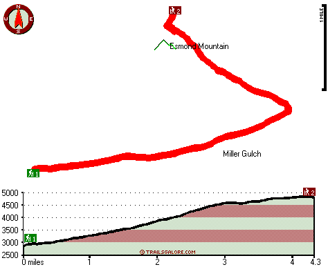
Trailhead 1 to Trailhead 2: Total hiking length = 4.3 miles Total climbing distance = 3.4 miles Difficulty : Difficult Casual Hiking Pace:
5 hours
Fast Hiking Pace:
3 hours
Trailhead 2 to Trailhead 1: Total hiking length = 4.3 miles Total climbing distance = .2 miles Difficulty : Easy Casual Hiking Pace:
3 hours
Fast Hiking Pace:
1.5 hours
| | Trailhead 1 back to Trailhead 1: Total hiking length = 8.6 miles Total climbing distance = 3.6 miles Difficulty : Difficult Casual Hiking Pace:
7.5 hours
Fast Hiking Pace:
5 hours
Trailhead 2 back to Trailhead 2: Total hiking length = 8.6 miles Total climbing distance = 3.6 miles Difficulty : Difficult Casual Hiking Pace:
7.5 hours
Fast Hiking Pace:
5 hours
|
Total elevation difference: 2366 feet

Lithia Springs Resort And Gardens, Ashland
|
13 miles away
Hello, from Ashland, Oregon Imagine, at the end of a long day's travel, relaxing in a 2 person whirlpool tub filled with hot mineral water, right in your own room. Let the relaxing quality of the min...
|
| |
Windmill Inn And Suites Of Ashland, Ashland
|
17 miles away
Discover one of the Northwests most luxurious inns. Escape civilizations cares without leaving its pleasures behind. Come and enjoy the quiet side of Ashland. All suite hotel with magnificent panora...
|
|
User input for Buck Point Trail, Southern Cascade Range, Jackson County, Oregon:

Outdoors Recreation Near Medford, Oregon Very comprehensive list of a variety of outdoors recreation in the vicinity of Medford, Oregon, the metro area neareast to Buck Point Trail. Find info on campgrounds, hiking trails, ski resorts, lakes, beaches, parks, whitewater and more.
|
Current weather conditions at Buck Point Trail, Southern Cascade Range, Jackson County, Oregon

Local climate location: MEDFORD WSO AP 10 miles away

           
| |
Holiday Inn Express Hotel & Suites ASHLAND, Ashland
|
17 miles away
The Holiday Inn Express Hotel & Suites in Ashland is the gateway to your Oregon adventure. Our hotel features a warm, elegant environment. Conveniently placed near all of Ashland's attractions includi...
|
Super 8 Ashland, Ashland
|
17 miles away
Super 8 Ashland, Oregon is AAA Approved, 100 per cent Non Smoking Rooms, convenient to I-5 adjacent Exit 14. We Have Wireless High Speed Internet, An Indoor Heated Pool, SuperStart breakfast, Micro-F...
|
|
More Hotels and Campgrounds Near Buck Point Trail, Southern Cascade Range, Jackson County, Oregon
| |
| |
 |
|
| These outdoors activities are available near Buck Point Trail. |
| | Trails Near Buck Point Trail:
 |
Bieberstedt Trail, Jackson County
County
, 4 miles away, 1.9 hiking miles, 1353 feet elevation difference |
 |
Pacific Crest Trail - section 19, County
County
, 8 miles away, 99.3 hiking miles, 3756 feet elevation difference |
 |
Dead End Trail, Jackson County
County
, 9 miles away, 5.4 hiking miles, 1311 feet elevation difference |
 |
Mosquito Fish Lake Trail, Jackson County
County
, 9 miles away, 7.2 hiking miles, 1976 feet elevation difference |
|
| | Whitewater Near Buck Point Trail:
 |
Big Butte Creek, Jackson County
County
, 11 miles away, Class III-IV - 9.5 miles long (Butte Falls to Netherlands Road) |
 |
Rogue River - North Fork, Jackson County
County
, 15 miles away, Class IV(V+) - 3.3 miles long (Mill Creek Falls to Lost Creek Lake) |
 |
Rogue River - North Fork, Jackson County
County
, 18 miles away, Class III - 6 miles long (River Bridge to North Fork Park) |
|
| | Hotels Near Buck Point Trail:
 |
Lithia Springs Resort And Gardens, Ashland
, 13 miles away |
 |
Windmill Inn And Suites Of Ashland, Ashland
, 17 miles away |
 |
Holiday Inn Express Hotel & Suites ASHLAND, Ashland
, 17 miles away |
 |
Super 8 Ashland, Ashland
, 17 miles away |
 |
Ashland Motel, Ashland
, 18 miles away |
|
|
|
 |
|