| |
|
| | Buck Canyon Trail is a long tour away from Medford, but it is a brilliant backpacking trail. Ok, you've been cooped up too long, time to get out in the wilderness a bit, and Buck Canyon Trail in Douglas County, Oregon is such a brilliant place. If you are in Oregon during backcountry hiking season you have to go backcountry hiking. Summertime highs at Buck Canyon Trail regularly tend to be in the 80's while overnight lows are regularly in the 40's. Throughout the winter highs are regularly in the 40's; overnight lows at Buck Canyon Trail during the winter regularly |
|
drop into the 20's. This backcountry trail is a mid length backcountry trail with an average amount of climbing distance which makes this hiking and backpacking trail magnificent for hard core backpackers looking for adventure. This backcountry hike shouldn't take more than 6.5
| | hours, but you never know stuff could go wrong and you could get stuck so be prepared for that. Hiking trails for hiking, and backpacking can be found all over Oregon, and one of those is Buck Canyon Trail in Douglas County. There are plenty of hiking trails in Oregon; each one of them has its own unique beauty. If you happen to be in Oregon, why not go hiking, it is so much fun. Buck Canyon Trail gets a lot of water; most of the rain falls during November, and July is the month with the least moisture. Being 7.4 miles long it's a mid length backcountry | |
|
hike. Now this wilderness trail is pretty long, so don't forget to pack enough supplies. You spend the whole backcountry hike in roughly the same elevation zone which means the conditions are about the same from start to finish. The beautiful backcountry trails of the Southern
Cascade Range are a great way to explore these highlands. This region does get very dry sometimes, so make sure you check current conditions and fire restrictions with local forest authorities before you head out. Please follow all local rules about fires and camping. There are
so many hiking and backpacking trails in this area. There are two trailheads to chose from, one in each end which means you have the option of trekking it one way if you have someone to pick you up at the other end. The total elevation difference for this hiking trail is 1,181
feet which is an average number.
Briefly about the general area: So much enjoyable stuff to do in the Southern Cascade Range, not enough time. West Fork Muir Creek is a stunning stream that is worth stopping at, and a good place like Alkali Meadows here at Buck Canyon
Trail is too good to miss. Camping is available at Haymaker Campground; if you haven’t been to Crater Lake National Park, you ought to schedule some time for it if you're here. There's just no way anybody can get bored here at Buck Canyon Trail. It's always fine to visit Muir
Creek Falls, and you ought to definitely dedicate some time to Lonesome Meadow if you're here at Buck Canyon Trail. There's no way somebody can get bored here in the Southern Cascade Range. Get your heart beating on the wonderful whitewater of Rogue River - North Fork. This river
is so great. Visit Ice Creek while you're here at Buck Canyon Trail, and a great place for whitewater paddling is Copland Creek. If you came for an overnight stay Camas Creek Campground is a perfect place to camp, and if you're here why not stop by Buck Canyon.
|
|
Location of Trailhead 1: Latitude 43.0916, Longitude -122.3451 - - Directions and Road Map
Location of Trailhead 2: Latitude 43.0919, Longitude -122.4042 - - Directions and Road Map

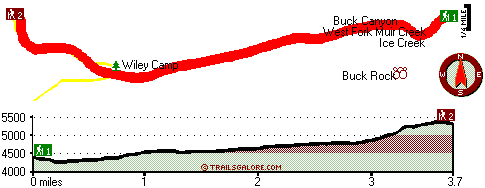
Trailhead 1 to Trailhead 2: Total hiking length = 3.7 miles Total climbing distance = 2.4 miles Difficulty : Medium Casual Hiking Pace:
4 hours
Fast Hiking Pace:
2 hours
Trailhead 2 to Trailhead 1: Total hiking length = 3.7 miles Total climbing distance = .7 miles Difficulty : Easy Casual Hiking Pace:
2.5 hours
Fast Hiking Pace:
1.5 hours
| | Trailhead 1 back to Trailhead 1: Total hiking length = 7.4 miles Total climbing distance = 3.1 miles Difficulty : Difficult Casual Hiking Pace:
6.5 hours
Fast Hiking Pace:
4 hours
Trailhead 2 back to Trailhead 2: Total hiking length = 7.4 miles Total climbing distance = 3.1 miles Difficulty : Difficult Casual Hiking Pace:
6.5 hours
Fast Hiking Pace:
4 hours
|
Total elevation difference: 1181 feet

Best Western Oakridge Inn, Oakridge
|
34 miles away
This Oakridge, Oregon hotel offers a complimentary continental breakfast each morning and convenient access to a variety of outdoor activities. Discover the Best Western Oakridge Inn, nestled agains...
|
| |
|
User input for Buck Canyon Trail, Southern Cascade Range, Douglas County, Oregon:

Outdoors Recreation Near Medford, Oregon Very comprehensive list of a variety of outdoors recreation in the vicinity of Medford, Oregon, the metro area neareast to Buck Canyon Trail. Find info on campgrounds, hiking trails, ski resorts, lakes, beaches, parks, whitewater and more.
|
Current weather conditions at Buck Canyon Trail, Southern Cascade Range, Douglas County, Oregon

Local climate location: TOKETEE FALLS 8 miles away

           
| |
Lithia Springs Resort And Gardens, Ashland
|
47 miles away
Hello, from Ashland, Oregon! Imagine, at the end of a long day's travel, relaxing in a 2 person whirlpool filled with hot mineral water, right in your own room. Lay back, Let the relaxing quality of t...
|
Super 8 Motel Medford OR, Medford
|
49 miles away
75 Rooms Indoor Heated Pool with an 80 Foot Waterslide Indoor Spa Easy Access Off I-5 Within 1 Mile From The Jacksonville Medford International Airport Within 3 Miles to Rogue Valley Regiona...
|
|
More Hotels and Campgrounds Near Buck Canyon Trail, Southern Cascade Range, Douglas County, Oregon
| |
| |
 |
|
| These outdoors activities are available near Buck Canyon Trail. |
| | Trails Near Buck Canyon Trail:
 |
Meadow Creek Trail, Douglas County
County
, 2 miles away, 5.4 hiking miles, 2389 feet elevation difference |
 |
Log Pile Trail, Douglas County
County
, 2 miles away, 5.2 hiking miles, 1832 feet elevation difference |
 |
Rattlesnake Way, Douglas County
County
, 3 miles away, 7.2 hiking miles, 2853 feet elevation difference |
 |
Rim Rock Trail, Douglas County
County
, 3 miles away, 0.8 hiking miles, 586 feet elevation difference |
 |
Three Lakes Trail, Douglas County
County
, 4 miles away, 4.4 hiking miles, 669 feet elevation difference |
 |
Rough Creek Trail, Douglas County
County
, 5 miles away, 5.2 hiking miles, 2837 feet elevation difference |
 |
Beaver Meadows Trail, Douglas County
County
, 6 miles away, 4.2 hiking miles, 526 feet elevation difference |
|
| | Whitewater Near Buck Canyon Trail:
 |
Rogue River - North Fork, Jackson County
County
, 13 miles away, Class IV - 3 miles long (Natural Bridge to Woodruff Bridge) |
 |
Copland Creek, Douglas County
County
, 15 miles away, Class IV(V) - 5.7 miles long (Second Bridge to North Umpqua) |
|
| | Hotels Near Buck Canyon Trail:
 |
Union Creek Resort, Prospect
, 10 miles away |
 |
Prospect Historical Hotel, Prospect
, 19 miles away |
 |
Mazama Village Motor Inn, Crater Lake
, 19 miles away |
 |
Steamboat Inn, Idleyld Park
, 28 miles away |
 |
Aspen Inn Motel, Fort Klamath
, 32 miles away |
|
|
|
 |
|