Oregon hiking trails - Brush Creek Trail, Central Cascade Range, Jefferson County

   
  Every backpacking and hiking trail in Oregon has its own character. Backpacking here in Oregon never gets boring. Brush Creek Trail is positioned a pretty lengthy journey from Bend, but it is an enjoyable place to walk. Don’t forget to check for any current restrictions or closures before you go. This is a vicinity covered with lots of backcountry hiking trails. There's not much difference in elevation along Brush Creek Trail which means the conditions are about the same from start to finish. This hiking and backpacking trail is a normal length hiking and
    backpacking trail with an average amount of climbing distance which makes it a glorious backcountry hiking trail for experienced trekkers in brilliant shape. In Oregon you never run out of outdoors fun. Brush Creek Trail is quite long, so make sure you bring plenty of supplies.
The hiking and backpacking trails of the Central Cascade Range are a really great way to spend quality time in the fresh air. Through the months of summer at Brush Creek Trail highs are ordinarily in the 70's. Once the sun is down it descends down to the 40's. The winter brings highs down to the 30's with temperatures at Brush Creek Trail dipping down into the 20's through winter nights. This backcountry walk shouldn't take more than 5.5 hours, but of course some folks walk a bit slower and some a bit faster. Brush Creek Trail is a one trailhead backpacking  
and hiking trail, so in and out is the way to hike it normally. There are so many tremendous backpacking and hiking trails for backpacking in Oregon, and Brush Creek Trail in Jefferson County is one of them. The total elevation difference for Brush Creek Trail is 1,347 feet, and that is about average. We all need to get out in the fresh air once in a while, and if you happen to be in Jefferson County of Oregon, Brush Creek Trail is an outstanding local backcountry trail for doing a bit of leg stretching. All the water falling down from the sky makes Brush Creek Trail a wet site; December is the wettest month with most rain while July is commonly the driest month. Sometimes this hiking and backpacking trail gets really dry, so make sure you check current conditions and fire restrictions with local forest authorities before you head out. With its 6.4 miles of walking distance it's an average length hiking and backpacking trail.

Briefly about the general area:
Places like Bear Valley Lake are good to check out, and Wizard Falls Campground is a wonderful local campground. There's no way anyone can get bored here in the Central Cascade Range. There's whitewater on Metolius River for all you adrenaline junkies, and do put some time aside to spend at Sugarpine Spring while you're here at Brush Creek Trail.
While staying at Brush Creek Trail you could always look at Bear Valley, and Brush Creek Trail is a glorious site to visit for more than one day, Black Butte Resort is a glorious site to camp nearby. There's just no way someone can get bored here at Brush Creek Trail. Whitewater paddling is not for everyone but if it's for you then we recommend Marion Creek It's always splendid to pop by Two Springs.

Location of Trailhead: Latitude 44.5551, Longitude -121.7504
- - Directions and Road Map

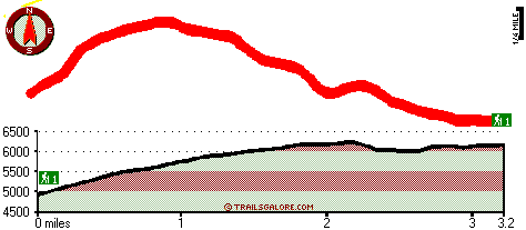
Total in and out hiking length = 6.4 miles

Total climbing distance = 2.7 miles

Difficulty : Difficult

Casual Hiking Pace: 5.5 hours

Fast Hiking Pace: 3.5 hours

Total elevation difference: 1347 feet


Lodge at Suttle Lake, Sisters
13 miles away
We are not your typical hotel. Nestled in the heart of the Deschutes National Forest amid soaring pines. Suttle Lake Resort provides an enchanted escape. Our resorts mountain views and pristine lake w...
  
Best Western Ponderosa Lodge, Sisters
20 miles away
Offers a refreshing environment with renovated rooms, new deluxe suites and smoke-free accommodations. The perfect choice while traveling the 'Gateway to the Cascades', ideally located on 14 acres sur...
User input for Brush Creek Trail, Central Cascade Range, Jefferson County, Oregon:

Submit Input:
Your Name:
Write or Paste Input here:

Upload picture:      Review Guidelines


Outdoors Recreation Near Bend, Oregon
Very comprehensive list of a variety of outdoors recreation in the vicinity of Bend, Oregon, the metro area neareast to Brush Creek Trail. Find info on campgrounds, hiking trails, ski resorts, lakes, beaches, parks, whitewater and more.

Current weather conditions at Brush Creek Trail, Central Cascade Range, Jefferson County, Oregon
WXPort

Local climate location: MARION FRKS FISH HATCH 17 miles away

Five Pine Lodge, Sisters
21 miles away
Lodging in Sisters, Oregon, at FivePine Lodge and Spa is a vacation back in time to Central Oregon's golden era of travel with every modern luxury. Whether you're practicing Tai-Chi atop Eagle Rock, p...

Mount Hood Inn, Government Camp
37 miles away
At the Mount Hood Inn we offer our guests the finest accommodations on the mountain. With our modern facilities and friendly local staff we are able to give you the attention and service you have com...

More Hotels and Campgrounds Near Brush Creek Trail, Central Cascade Range, Jefferson County, Oregon

OTHER_INFO
  Central Cascade Range Campgrounds
Complete list of all the campgrounds in the Central Cascade Range.

Central Cascade Range Outdoors Info
Complete outdoors info for the Central Cascade Range.

Oregon Hiking Trails
Complete list of all hiking trails in Oregon

Books about hiking trails in Oregon
List of books available on Amazon.com about hiking trails in Oregon.

Oregon Outdoors Index
This is a very comprehensive index of outdoors activities in the great state of Oregon.


TOPO
High quality water resistant topo map of Brush Creek Trail, Central Cascade Range, Jefferson County, Oregon.

OUTDOORS_GUIDE
These outdoors activities are available near Brush Creek Trail.
 Trails Near Brush Creek Trail:
Summit Trail, Jefferson County County , 2 miles away,  7.4 hiking miles, 1790 feet elevation difference
Cabot Lake Trail, Jefferson County County , 2 miles away,  6.8 hiking miles, 941 feet elevation difference
Minto Pass Trail, Linn County County , 3 miles away,  8.4 hiking miles, 967 feet elevation difference
Sugar Pine Ridge Trail, Jefferson County County , 4 miles away,  13.8 hiking miles, 2926 feet elevation difference
Jefferson Lake Trail, Jefferson County County , 4 miles away,  16.2 hiking miles, 2516 feet elevation difference
Swallow Lake Trail, Linn County County , 5 miles away,  14.4 hiking miles, 3182 feet elevation difference
Jefferson Creek Trail, Jefferson County County , 5 miles away,  15.4 hiking miles, 1123 feet elevation difference
 Camp Grounds Near Brush Creek Trail:
Wizard Falls Campground, Jefferson County, 10 miles away
Black Butte Resort, Camp Sherman, 10 miles away
Cold Springs Resort, Camp Sherman, 10 miles away
Trout Lake Campground, Jefferson County, 12 miles away
Suttle Lake Resort and Marina, Sisters, 12 miles away
 Whitewater Near Brush Creek Trail:
Marion Creek, Linn County County , 9 miles away, Class IV(V) - 7 miles long (Gooch Falls)
Metolius River, Jefferson County County , 16 miles away, Class III-IV - 28.5 miles long (Riverside Forest Campground to Lake Billy Chinook)
 Hotels Near Brush Creek Trail:
Lodge at Suttle Lake, Sisters , 13 miles away
Best Western Ponderosa Lodge, Sisters , 20 miles away
Five Pine Lodge, Sisters , 21 miles away
Mount Hood Inn, Government Camp , 37 miles away
The Inn Of The Seventh Mountain, Bend , 38 miles away
 Lakes Near Brush Creek Trail
Patsy Lake, Jefferson County , 3 miles away

Outdoors related information copyright © Stratus-Pikpuk, Inc. - Detailed hotel information copyright © Interactive Hotel Solutions