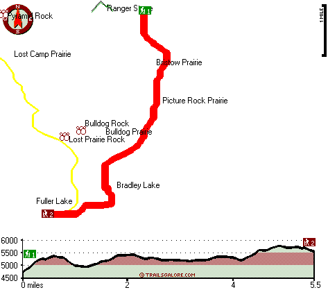
| |
|
| | As long as you like the wilderness you will like Oregon. When you're here in Oregon backcountry backpacking along one of its backcountry trails is the great thing to do. Finally, backcountry trekking time is here again, and Bristow Trail in Douglas County, Oregon is such a great place. Because Bristow Trail is very distant from civilization, it is one of many fine backpacking and hiking trails in this vicinity. The backcountry hiking trail stays roughly within the same elevation zone the whole time which means the conditions are about the same from start |
|
to finish. Bristow Trail sees pretty high levels of precipitation; the month of November is the wettest with most of the rain; the driest month of the year is July. Don’t forget to check for any current restrictions or closures before you go. Summertime highs at Bristow Trail commonly
| | tend to be in the 80's, and through the night it cools down to the 50's. Highs through the winter are frequently in the 40's while the cold winter nights at Bristow Trail are in the 30's. This walk should take you about 1.5 days, so better have big backpack to fit all the stuff you need. Backcountry hiking trails for backcountry backpacking, and backpacking can be found all over Oregon, and one of those is Bristow Trail in Douglas County. With its 11 miles of walking distance; it's considered a longer walk. This great outdoors hiking trail has a total | |
|
elevation difference of 1,267 feet which is about average. This is an area covered with lots of wilderness hiking trails. Bristow Trail is quite long, so do pack enough food to last the whole trip. Great outdoors trails like this one here in the Central Cascade Range are a very
great way to see these mountaintops. This great outdoors hiking trail has two trailheads, so backcountry trekking it one way is an option if you can arrange for a ride back. There are plenty of backcountry trails in Oregon; each one of them has its own character. Bristow Trail
is a very long great outdoors trail with an average amount of climbing distance which makes this wilderness hiking trail splendid for hard core backpackers looking for adventure. Sometimes this trail gets really dry, so do check for current fire restrictions before you go if you
plan to bring a stove or make a camp fire.
Briefly about the general area: But wait, there's more cool things to do in the Central Cascade Range. While you're here at Bristow Trail it's a great idea to explore Picture Rock Prairie, and a tremendous spot for whitewater
paddling is Steamboat Creek. Just can't get enough of Bristow Trail. Do set aside some time for Bulldog Prairie since you're here at Bristow Trail, and get your pulse rate up on the perfect whitewater of Copland Creek. Stay the night at Weeping Rock Campground; a tour to Bristow
Trail wouldn't be complete without taking a look at Illahee Spring. Visit Deadwood Creek while you're here at Bristow Trail; Bristow Trail is a great site to camp, Slim Chance Campground is a great site. This river is always fun. Don't forget to take a perfect little spree to North
Fork Indian Creek, and the beauty of mother nature reveals herself at Dome Spring. Not enough hours in a day to enjoy the Central Cascade Range.
|
|
Location of Trailhead 1: Latitude 43.4559, Longitude -122.4621 - - Directions and Road Map
Location of Trailhead 2: Latitude 43.3998, Longitude -122.4889 - - Directions and Road Map

Trailhead 1 to Trailhead 2: Total hiking length = 5.5 miles Total climbing distance = 2.6 miles Difficulty : Medium Casual Hiking Pace:
5 hours
Fast Hiking Pace:
3 hours
Trailhead 2 to Trailhead 1: Total hiking length = 5.5 miles Total climbing distance = 2.1 miles Difficulty : Medium Casual Hiking Pace:
4.5 hours
Fast Hiking Pace:
2.5 hours
| | Trailhead 1 back to Trailhead 1: Total hiking length = 11 miles Total climbing distance = 4.7 miles Difficulty : Difficult Casual Hiking Pace:
1.5 days
Fast Hiking Pace:
6.5 hours
Trailhead 2 back to Trailhead 2: Total hiking length = 11 miles Total climbing distance = 4.7 miles Difficulty : Difficult Casual Hiking Pace:
1.5 days
Fast Hiking Pace:
6.5 hours
|
Total elevation difference: 1267 feet

Best Western Oakridge Inn, Oakridge
|
16 miles away
This Oakridge, Oregon hotel offers a complimentary continental breakfast each morning and convenient access to a variety of outdoor activities. Discover the Best Western Oakridge Inn, nestled agains...
|
| |
Moonstone Village Green Resort, Cottage Grove
|
43 miles away
Village Green Resort is located off Interstate 5, in Cottage Grove. The resort is six miles from the covered bridges, and approximately 30 miles from Eugene Airport. We are less than a mile from two g...
|
|
User input for Bristow Trail, Central Cascade Range, Douglas County, Oregon:

Outdoors Recreation Near Eugene-Springfield, Oregon Very comprehensive list of a variety of outdoors recreation in the vicinity of Eugene-Springfield, Oregon, the metro area neareast to Bristow Trail. Find info on campgrounds, hiking trails, ski resorts, lakes, beaches, parks, whitewater and more.
More Hotels and Campgrounds Near Bristow Trail, Central Cascade Range, Douglas County, Oregon
| |
| |
 |
|
| These outdoors activities are available near Bristow Trail. |
| | Trails Near Bristow Trail:
 |
Boulder Creek Trail, Douglas County
County
, 3 miles away, 7.2 hiking miles, 3222 feet elevation difference |
 |
Lost Camp Trail, Douglas County
County
, 3 miles away, 7.9 hiking miles, 3991 feet elevation difference |
 |
Cinder Prairie Way, Douglas County
County
, 4 miles away, 10 hiking miles, 3151 feet elevation difference |
 |
Perry Butte Way, Douglas County
County
, 5 miles away, 4.5 hiking miles, 1801 feet elevation difference |
 |
Grassy Ranch Trail, Douglas County
County
, 5 miles away, 3.5 hiking miles, 684 feet elevation difference |
 |
Staley Ridge Trail, Douglas County
County
, 5 miles away, 9.1 hiking miles, 2524 feet elevation difference |
 |
Spring Mountain Way, Douglas County
County
, 6 miles away, 6.4 hiking miles, 4292 feet elevation difference |
|
| | Whitewater Near Bristow Trail:
 |
Copland Creek, Douglas County
County
, 8 miles away, Class IV(V) - 5.7 miles long (Second Bridge to North Umpqua) |
 |
Steamboat Creek, Douglas County
County
, 12 miles away, Class II+(IV) - 9.5 miles long (City Creek to Steamboat Falls) |
 |
Brice Creek, Lane County
County
, 14 miles away, Class IV-V - 4.5 miles long (Parker Falls to Champion Creek) |
 |
Hills Creek, Lane County
County
, 15 miles away, Class IV - 6 miles long (6 mi above Reservoir) |
 |
Steamboat Creek, Douglas County
County
, 15 miles away, Class IV - 6 miles long (Steamboat Falls to Canton Creek Campground) |
|
| | Hotels Near Bristow Trail:
 |
Arbor Inn, Oakridge
, 16 miles away |
 |
Oakridge Motel, Oakridge
, 16 miles away |
 |
Cascade Motel & Storage, Oakridge
, 16 miles away |
 |
Best Western Oakridge Inn, Oakridge
, 16 miles away |
 |
Steamboat Inn, Idleyld Park
, 19 miles away |
|
|
|
 |
|