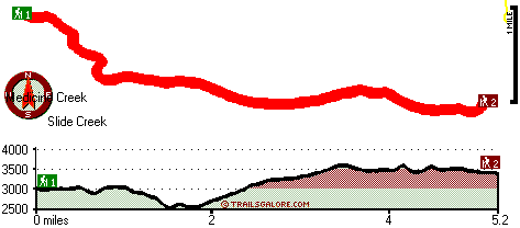
| |
|
| | There are backcountry trails all over Oregon; Bradley Trail in Douglas County is one of them. This part of Oregon has a great deal of available outdoors activities. There are numerous backcountry trails in Oregon, and each one is worth backpacking. Trekking here in the Central Cascade Range is a great way to explore these peaks. At parts of the year this region sees very little rain, so don’t forget to check for any current fire restrictions before you go. The warmest time of the year brings highs in the 80's to Bradley Trail while nighttime lows are |
|
frequently in the 40's. During the winter this site gets highs in the 40's while Bradley Trail nighttime low temperatures through the winter are in the 30's. Bradley Trail is 10.4 miles long; it's longer than many backpacking and hiking trails. Bradley Trail is a two ended hiking
| | trail with two trailheads, so if you can get a ride from someone, you can hike it just one way. Spending too much time indoors got you down? No problem, Bradley Trail in Douglas County, Oregon is just the place. The high level of rainfall makes Bradley Trail a rather wet site; of all the months in a year November is the one with the most rain while July is generally the driest month. This is just one of a large number of hiking trails in this region. Bradley Trail being so distant from the closest city, if you're looking for a nice place to go trekking, | |
|
this is a nice pick. Please follow all local rules about fires and camping. The total elevation difference for Bradley Trail is 1,195 feet which is an average number. Backcountry trekking here in Oregon is a wonderful way to spend some time. There's not much difference in elevation
along Bradley Trail, so you get pretty much the same conditions along the whole backpacking and hiking trail. This backpacking and hiking trail is many miles long having an average number of uphill miles which makes it a good hiking trail for experienced backcountry walkers in
great shape. Of course, this is an overnight backcountry walk, 1.5 days normally, so it's an outstanding thing if your backpack is big enough to do the job. Keep in mind that this is a long hiking trail, so make sure you bring plenty of supplies.
Briefly about the general
area: This is a really good river. Bridge Prairie is a perfect site here at Bradley Trail, and there are some magnificent whitewater spots on Copland Creek. A short trip to Cedar Spring is always worthwhile, and the scenery at Slide Creek Dam is striking. This river is
a wonderful place to visit. But wait, there's more to do right next door to Bradley Trail. There's a forest here at Bradley Trail called Ringtail Pine; there's whitewater on Steamboat Creek for all you adrenaline rush seekers. Having a splendid time in the Central Cascade Range
is uncomplicated. Fish Creek is a glorious local stream; don’t forget to have a look at Mountain Meadows if you're here at Bradley Trail. Slide Creek is a great spot to go to, and why not camp at Camas Creek Campground if you're here at Bradley Trail. You just can't picture
the amount of outdoors entertaining things the Central Cascade Range has to offer. Toketee Falls is a picturesque location to go to while you're at Bradley Trail, and camping at Bradley Trail is magnificent fun, Weeping Rock Campground is a magnificent local campground.
|
|
Location of Trailhead 1: Latitude 43.3098, Longitude -122.4746 - - Directions and Road Map
Location of Trailhead 2: Latitude 43.2968, Longitude -122.4061 - - Directions and Road Map

Trailhead 1 to Trailhead 2: Total hiking length = 5.2 miles Total climbing distance = 2.6 miles Difficulty : Medium Casual Hiking Pace:
5 hours
Fast Hiking Pace:
2.5 hours
Trailhead 2 to Trailhead 1: Total hiking length = 5.2 miles Total climbing distance = 1.9 miles Difficulty : Medium Casual Hiking Pace:
4.5 hours
Fast Hiking Pace:
2.5 hours
| | Trailhead 1 back to Trailhead 1: Total hiking length = 10.4 miles Total climbing distance = 4.5 miles Difficulty : Difficult Casual Hiking Pace:
1.5 days
Fast Hiking Pace:
6 hours
Trailhead 2 back to Trailhead 2: Total hiking length = 10.4 miles Total climbing distance = 4.5 miles Difficulty : Difficult Casual Hiking Pace:
1.5 days
Fast Hiking Pace:
6 hours
|
Total elevation difference: 1195 feet

Best Western Oakridge Inn, Oakridge
|
23 miles away
This Oakridge, Oregon hotel offers a complimentary continental breakfast each morning and convenient access to a variety of outdoor activities. Discover the Best Western Oakridge Inn, nestled agains...
|
| |
Moonstone Village Green Resort, Cottage Grove
|
48 miles away
Village Green Resort is located off Interstate 5, in Cottage Grove. The resort is six miles from the covered bridges, and approximately 30 miles from Eugene Airport. We are less than a mile from two g...
|
|
User input for Bradley Trail, Central Cascade Range, Douglas County, Oregon:

Outdoors Recreation Near Medford, Oregon Very comprehensive list of a variety of outdoors recreation in the vicinity of Medford, Oregon, the metro area neareast to Bradley Trail. Find info on campgrounds, hiking trails, ski resorts, lakes, beaches, parks, whitewater and more.
More Hotels and Campgrounds Near Bradley Trail, Central Cascade Range, Douglas County, Oregon
| |
| |
 |
|
| These outdoors activities are available near Bradley Trail. |
| | Trails Near Bradley Trail:
 |
Perry Butte Way, Douglas County
County
, 2 miles away, 4.5 hiking miles, 1801 feet elevation difference |
 |
Cinder Prairie Way, Douglas County
County
, 3 miles away, 10 hiking miles, 3151 feet elevation difference |
 |
Mountain Meadows Trail, Douglas County
County
, 3 miles away, 2.2 hiking miles, 1752 feet elevation difference |
 |
Boulder Creek Trail, Douglas County
County
, 5 miles away, 7.2 hiking miles, 3222 feet elevation difference |
 |
Grave Creek Trail, Douglas County
County
, 6 miles away, 6.2 hiking miles, 3150 feet elevation difference |
 |
Spring Mountain Way, Douglas County
County
, 6 miles away, 6.4 hiking miles, 4292 feet elevation difference |
 |
Staley Ridge Trail, Douglas County
County
, 7 miles away, 9.1 hiking miles, 2524 feet elevation difference |
|
| | Whitewater Near Bradley Trail:
 |
Copland Creek, Douglas County
County
, 7 miles away, Class IV(V) - 5.7 miles long (Second Bridge to North Umpqua) |
 |
Steamboat Creek, Douglas County
County
, 15 miles away, Class II+(IV) - 9.5 miles long (City Creek to Steamboat Falls) |
 |
Steamboat Creek, Douglas County
County
, 18 miles away, Class IV - 6 miles long (Steamboat Falls to Canton Creek Campground) |
 |
Hills Creek, Lane County
County
, 20 miles away, Class IV - 6 miles long (6 mi above Reservoir) |
 |
Jackson Creek, Douglas County
County
, 20 miles away, Class IV(V) - 8 miles long (NF300 to Cover Camp) |
|
| | Hotels Near Bradley Trail:
 |
Union Creek Resort, Prospect
, 20 miles away |
 |
Steamboat Inn, Idleyld Park
, 21 miles away |
 |
Arbor Inn, Oakridge
, 22 miles away |
 |
Oakridge Motel, Oakridge
, 22 miles away |
 |
Cascade Motel & Storage, Oakridge
, 23 miles away |
|
| | Lakes Near Bradley Trail
 |
Slide Creek Reservoir, Douglas County
, 1 miles away |
 |
Fish Creek Forebay, Douglas County
, 2 miles away |
|
|
|
 |
|