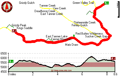
Oregon hiking trails - Boundary Trail, Klamath Mountains, Josephine County

   
  Splendid trails in Oregon are in abundance, and one of those is Boundary Trail in Josephine County. It's a lengthy journey from Grants Pass to Boundary Trail, but when you trek it you're always having a perfect time. Here in the glorious state of Oregon backpacking is always an amusing thing to do. Boundary Trail regularly gets a large amount of rainfall; December is the wettest month with most rain, and the driest month of the year is July. This part of Oregon is always a delight to explore during backcountry trekking season. Of course, this is an overnight
    walk, 2.5 days normally, so it's a tremendous thing if your backpack is big enough to do the job. The wonderful wilderness trails of the Klamath Mountains are the best way to enjoy these hills. This is a long wilderness trail, so make sure you bring plenty of supplies. This wilderness
trail sometimes gets very dry, so do check for current fire restrictions before you go if you plan to bring a stove or make a camp fire. Boundary Trail is a very long wilderness trail with an average amount of climbing distance which makes it a brilliant backpacking and hiking trail for experienced backcountry walkers in wonderful shape. Different parts of this trail are at very different elevations, so keep in mind that you may need to dress differently at different elevations. Don’t forget to check for any current restrictions or closures before you  
go. Boundary Trail is a two ended backpacking trail with two trailheads, so if you can get a ride from someone, you can walk it just one way. With its 17.2 miles of walking distance; it's longer than many trails. Boundary Trail has a total elevation difference of 1,741 feet, and that is about average. Ok, you've been cooped up too long, time to get out in the outdoors a bit, and if you happen to be in Josephine County of Oregon, Boundary Trail is a perfect local wilderness trail for doing a bit of leg stretching. Summertime brings highs in the 80's to Boundary Trail. Once the sun is down it sinks down to the 40's. The wintertime comes with highs in the 40's; night lows during the wintertime for Boundary Trail tend to be in the 30's. There are so many backpacking and hiking trails in this area. Every Oregon trail is worth backpacking.

Briefly about the general area:
Cedar Spring is an inspiring place to have a look at during your stay. Thirteenmile Creek is a fine local stream; there's whitewater on Elk Creek for all you adrenaline people.
Looking for a nice visit? Oregon Caves National Monument is relatively near Boundary Trail, and why not a little side journey to Yew Creek. Here at Boundary Trail you'll in all probability meet some folks from Grants Pass, and Phantom Meadows is a beautiful place any time of year. Having a brilliant time in the Klamath Mountains is uncomplicated. Stay the night at West Branch Campground, and there are some good whitewater spots on Indian Creek Klamath Tributary.
You just can't imagine the amount of outdoors enjoyable stuff the Klamath Mountains has to offer. There's so much to do here at Boundary Trail that you need to camp here for a while, Klamath RV Park is a nice place for that, and a journey to Boundary Trail wouldn't be complete without taking a look at Horse Spring. This place, Boundary Trail, it just has so much outdoors fun stuff. A pleasant spree to Elkhorn Prairie is a great way to spend an afternoon; if you yearn for a little side visit, try Fehley Gulch.

Location of Trailhead 1: Latitude 42.0389, Longitude -123.3487
- - Directions and Road Map

Location of Trailhead 2: Latitude 42.0141, Longitude -123.4313
- - Directions and Road Map


Trailhead 1 to Trailhead 2:
Total hiking length = 8.6 miles
Total climbing distance = 3.8 miles
Difficulty : Difficult
Casual Hiking Pace: 7.5 hours
Fast Hiking Pace: 4.5 hours

Trailhead 2 to Trailhead 1:
Total hiking length = 8.6 miles
Total climbing distance = 4.1 miles
Difficulty : Difficult
Casual Hiking Pace: 8 hours
Fast Hiking Pace: 4.5 hours
    Trailhead 1 back to Trailhead 1:
Total hiking length = 17.2 miles
Total climbing distance = 7.9 miles
Difficulty : Difficult
Casual Hiking Pace: 2.5 days
Fast Hiking Pace: 1.5 days

Trailhead 2 back to Trailhead 2:
Total hiking length = 17.2 miles
Total climbing distance = 7.9 miles
Difficulty : Difficult
Casual Hiking Pace: 2.5 days
Fast Hiking Pace: 1.5 days

Total elevation difference: 1741 feet


Riverside Inn, Grants Pass
22 miles away
As the largest hotel on the Rogue River-Riverside Inn resort and conference center is a preferred location for lodging needs in the area. The Inn boasts spacious guestrooms -all of them with private b...
  
Holiday Inn Express GRANTS PASS, Grants Pass
22 miles away
The Holiday Inn Express Grants Pass is conveniently located at the junction of Interstate 5 and the Redwood Hwy (Hwy 199). Our lodging offers you easy access to Rogue River thrills, antique shopping, ...
User input for Boundary Trail, Klamath Mountains, Josephine County, Oregon:

Submit Input:
Your Name:
Write or Paste Input here:

Upload picture:      Review Guidelines


Outdoors Recreation Near Grants Pass, Oregon
Very comprehensive list of a variety of outdoors recreation in the vicinity of Grants Pass, Oregon, the metro area neareast to Boundary Trail. Find info on campgrounds, hiking trails, ski resorts, lakes, beaches, parks, whitewater and more.

Current weather conditions at Boundary Trail, Klamath Mountains, Josephine County, Oregon
WXPort

Local climate location: CAVE JUNCTION 4 miles away

Best Western Grants Pass Inn, Grants Pass
22 miles away
Situated at the junction of Interstate 5 and Highway 199, this Grants Pass hotel is just minutes from the famous Rogue River in Oregon. The Best Western Grants Pass Inn is surrounded by beautiful mo...

Sweet Breeze Inn, Grants Pass
23 miles away
Welcome to the Sweet Breeze Inn. Our motel in Grants Pass proudly offers all non smoking rooms. There is an outside covered garden patio for those that do indulge. Wireless Internet Access is availabl...

More Hotels and Campgrounds Near Boundary Trail, Klamath Mountains, Josephine County, Oregon

OTHER_INFO
  Klamath Mountains Campgrounds
Complete list of all the campgrounds in the Klamath Mountains.

Klamath Mountains Outdoors Info
Complete outdoors info for the Klamath Mountains.

Oregon Hiking Trails
Complete list of all hiking trails in Oregon

Books about hiking trails in Oregon
List of books available on Amazon.com about hiking trails in Oregon.

Oregon Outdoors Index
This is a very comprehensive index of outdoors activities in the great state of Oregon.


TOPO
High quality water resistant topo map of Boundary Trail, Klamath Mountains, Josephine County, Oregon.

OUTDOORS_GUIDE
These outdoors activities are available near Boundary Trail.
 Trails Near Boundary Trail:
Sucker Creek Trail, Josephine County County , 1 miles away,  8.2 hiking miles, 1978 feet elevation difference
East Fork Sucker Creek Trail, Josephine County County , 2 miles away, 6.4 hiking miles, 3375 feet elevation difference
Green Valley Trail, Josephine County County , 3 miles away,  1.4 hiking miles, 810 feet elevation difference
Limestone Trail, Josephine County County , 4 miles away, 4.4 hiking miles, 2926 feet elevation difference
Bolan Lake Trail, Josephine County County , 4 miles away, 1.9 hiking miles, 563 feet elevation difference
Lake Mountain Trail, Josephine County County , 4 miles away, 5.3 hiking miles, 1760 feet elevation difference
Oregon Caves Trail, Josephine County County , 5 miles away, 5.7 hiking miles, 1673 feet elevation difference
 Camp Grounds Near Boundary Trail:
West Branch Campground, Siskiyou County, 7 miles away
Klamath RV Park, Happy Camp, 11 miles away
Country Hills Resort, Cave Junction, 11 miles away
Elk Creek Campground & Recreational Vehicle Park, Happy Camp, 12 miles away
Curley Jack Campground, Siskiyou County, 12 miles away
 Whitewater Near Boundary Trail:
Indian Creek Klamath Tributary, Siskiyou County County , 10 miles away, Class III - 7.6 miles long (confluence South and East Fork to Klamath River)
Elk Creek, Siskiyou County County , 14 miles away, Class I-IV - 5 miles long (Elk Creek Road to Klamath River)
Klamath River, Siskiyou County County , 17 miles away, Class III+(IV) - 18 miles long (Happy Camp to Coon Creek)
Klamath River, Siskiyou County County , 17 miles away, Class III - 36 miles long (Sarah Totten Campground to Happy Camp)
Trace Creek, Siskiyou County County , 18 miles away, Class IV-V - 7 miles long (Bear Pen Creek to Klamath River)
 National Parks Near Boundary Trail:
Oregon Caves National Monument, Cave Junction - OR , 17 miles away
Redwood National and State Parks, Crescent City - CA , 55 miles away
 Hotels Near Boundary Trail:
Riverside Inn, Grants Pass , 22 miles away
Holiday Inn Express GRANTS PASS, Grants Pass , 22 miles away
Best Western Grants Pass Inn, Grants Pass , 22 miles away
Sweet Breeze Inn, Grants Pass , 23 miles away
Comfort Inn Grants Pass, Grants Pass , 23 miles away
 Lakes Near Boundary Trail
Fish Lake, Josephine County , 5 miles away

Outdoors related information copyright © Stratus-Pikpuk, Inc. - Detailed hotel information copyright © Interactive Hotel Solutions