| |
|
| | Each one of the many backpacking trails of Oregon is different from the others. Boulder Creek Trail being so secluded from the most adjacent city, it is an amusing site to trek. Oregon is a good place for outdoors people. Backpacking trails are good and plentiful in Oregon; one of them being Boulder Creek Trail in Douglas County. Keep in mind that this is a long backpacking and hiking trail, so do pack enough food to last the whole trip. These hiking trails here in the Central Cascade Range are a really brilliant way to spend quality time in nature. The |
|
high level of rainfall makes Boulder Creek Trail a pretty wet site; all through the month of November you get the most rain around here, and the driest month is July. You should count on this backcountry hike taking about 6.5 hours, but of course some people walk a bit slower and
| | some a bit faster. This vicinity does get very dry sometimes, so don’t forget to check for any current fire restrictions before you go. Please follow all local rules about fires and camping. Can’t wait to get out in the great outdoors, Boulder Creek Trail in Douglas County, Oregon is the great outdoors at its best. Throughout the months of summer highs here at Boulder Creek Trail reach the 70's while night lows are generally in the 40's. Throughout the winter highs are generally in the 40's, and after the sun is down during the winter temperatures at Boulder | |
|
Creek Trail dip into the 30's. Boulder Creek Trail has a total elevation difference of 3,222 feet, and that is higher than average. Boulder Creek Trail has only one trailhead, so in and out is the way to backcountry walk it normally. This hiking trail is a normal length hiking
trail with an average amount of climbing distance which makes this a very tough backcountry hiking trail for advanced backcountry trekkers looking for an outstanding challenge. This is one of many backcountry hiking trails in the surrounding area. Boulder Creek Trail goes through
some very different elevations, so keep in mind that you may need to dress differently at different elevations. Going for a hike here in Oregon never gets boring. With its 7.2 miles of walking distance it's a mid length hike.
Briefly about the general area: If you adore
the outdoors, you'll fancy Boulder Creek Trail. Bulldog Prairie is a great place. Whitewater paddling is brilliant on Steamboat Creek, and dropping by Crater Lake National Park is just something you need to do if you haven't yet. A delightful place to camp here at Boulder Creek
Trail is Slim Chance Campground, and there's some flowing water nearby, Onion Creek is a stream you can visit while here. Life's too short to enjoy all the enjoyable things in the Central Cascade Range. Spring Creek flows through this vicinity, and a journey to Horse Prairie revitalizes
the soul. Why not camp at Weeping Rock Campground if you're here at Boulder Creek Trail, and in case you don’t mind getting wet, you can always go whitewater paddling on Copland Creek.
|
|
Location of Trailhead: Latitude 43.3947, Longitude -122.4804 - - Directions and Road Map
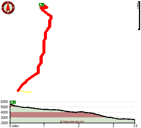
Total in and out hiking length = 7.2 miles
Total climbing distance = 3.1 miles
Difficulty : Difficult
Casual Hiking Pace:
6.5 hours
Fast Hiking Pace:
4 hours
Total elevation difference: 3222 feet

Best Western Oakridge Inn, Oakridge
|
19 miles away
This Oakridge, Oregon hotel offers a complimentary continental breakfast each morning and convenient access to a variety of outdoor activities. Discover the Best Western Oakridge Inn, nestled agains...
|
| |
Moonstone Village Green Resort, Cottage Grove
|
44 miles away
Village Green Resort is located off Interstate 5, in Cottage Grove. The resort is six miles from the covered bridges, and approximately 30 miles from Eugene Airport. We are less than a mile from two g...
|
|
User input for Boulder Creek Trail, Central Cascade Range, Douglas County, Oregon:

Outdoors Recreation Near Eugene-Springfield, Oregon Very comprehensive list of a variety of outdoors recreation in the vicinity of Eugene-Springfield, Oregon, the metro area neareast to Boulder Creek Trail. Find info on campgrounds, hiking trails, ski resorts, lakes, beaches, parks, whitewater and more.
More Hotels and Campgrounds Near Boulder Creek Trail, Central Cascade Range, Douglas County, Oregon
| |
| |
 |
|
| These outdoors activities are available near Boulder Creek Trail. |
| | Trails Near Boulder Creek Trail:
 |
Cinder Prairie Way, Douglas County
County
, 2 miles away, 10 hiking miles, 3151 feet elevation difference |
 |
Bristow Trail, Douglas County
County
, 3 miles away, 5.5 hiking miles, 1267 feet elevation difference |
 |
Perry Butte Way, Douglas County
County
, 3 miles away, 4.5 hiking miles, 1801 feet elevation difference |
 |
Grassy Ranch Trail, Douglas County
County
, 4 miles away, 3.5 hiking miles, 684 feet elevation difference |
 |
Lost Camp Trail, Douglas County
County
, 4 miles away, 7.9 hiking miles, 3991 feet elevation difference |
 |
Spring Mountain Way, Douglas County
County
, 4 miles away, 6.4 hiking miles, 4292 feet elevation difference |
 |
Bradley Trail, Douglas County
County
, 5 miles away, 5.2 hiking miles, 1195 feet elevation difference |
|
| | Whitewater Near Boulder Creek Trail:
 |
Copland Creek, Douglas County
County
, 6 miles away, Class IV(V) - 5.7 miles long (Second Bridge to North Umpqua) |
 |
Steamboat Creek, Douglas County
County
, 12 miles away, Class II+(IV) - 9.5 miles long (City Creek to Steamboat Falls) |
 |
Steamboat Creek, Douglas County
County
, 14 miles away, Class IV - 6 miles long (Steamboat Falls to Canton Creek Campground) |
|
| | Hotels Near Boulder Creek Trail:
 |
Best Western Oakridge Inn, Oakridge
, 19 miles away |
 |
Moonstone Village Green Resort, Cottage Grove
, 44 miles away |
 |
Comfort Inn Cottage Grove, Cottage Grove
, 44 miles away |
 |
Holiday Inn Express COTTAGE GROVE, Cottage Grove
, 44 miles away |
 |
Comfort Inn & Suites Creswell, Creswell
, 45 miles away |
|
|
|
 |
|