| |
This backpacking trail has a total elevation difference of 2,416 feet, and that is about average. Bonney Meadows Trail is 7 miles long it's a mid length walk. Bonney Meadows Trail goes through some very different elevations, so keep in mind that you may need to dress differently at different elevations. This region does get very dry sometimes, so do check for current fire restrictions before you go if you plan to bring a stove or make a camp fire. This backpacking trail has two trailheads, so if you can get a ride from someone, you can backcountry hike it just one way. This is a long hiking trail, so don't forget to pack enough supplies. This backcountry trek shouldn't take more than 6 hours, but of course some folks walk a bit slower and some a bit faster.
|
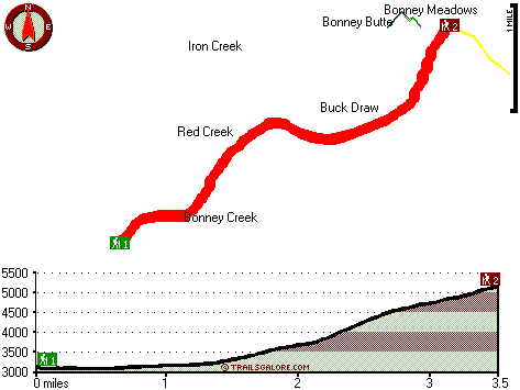
Trailhead 1 to Trailhead 2:
Total hiking length = 3.5 miles
Total climbing distance = 2.5 miles
Difficulty : Difficult
Casual Hiking Pace:
3.5 hours
Fast Hiking Pace:
2 hours
Trailhead 2 to Trailhead 1:
Total hiking length = 3.5 miles
Total climbing distance = .1 miles
Difficulty : Easy
Casual Hiking Pace:
2 hours
Fast Hiking Pace:
1 hours
| | Trailhead 1 back to Trailhead 1:
Total hiking length = 7 miles
Total climbing distance = 2.6 miles
Difficulty : Difficult
Casual Hiking Pace:
6 hours
Fast Hiking Pace:
4 hours
Trailhead 2 back to Trailhead 2:
Total hiking length = 7 miles
Total climbing distance = 2.6 miles
Difficulty : Difficult
Casual Hiking Pace:
6 hours
Fast Hiking Pace:
4 hours
|
Total elevation difference: 2416 feet
|


