Oregon hiking trails - Blue Rock Trail, Southern Cascade Range, Klamath County

   
  Oregon has plenty of wonderful great outdoors hiking trails, and among these are Blue Rock Trail in Klamath County. You'll need to go far from Klamath Falls to get to Blue Rock Trail, but you always have a magnificent time when you're hiking along it. Every great outdoors hiking trail in Oregon has something unique to offer. Here in Oregon backpacking is a great idea. This is a region covered with lots of hiking and backpacking trails. Summertime highs at Blue Rock Trail commonly tend to be in the 80's. All through the moonlight hours it's regularly in
    the 40's. Daytime highs throughout the wintertime are in the 40's with winter lows in the 20's overnight here at Blue Rock Trail. Please follow all local rules about fires and camping. The amount of precipitation that falls at Blue Rock Trail is near the national average; November
is when you get the most rain here, and July on the other hand is the driest. Now, this is roughly a 2-day hike, so it's a nice thing if your backpack is big enough to do the job. This backcountry hiking trail sometimes gets very dry, so make sure you check current conditions and fire restrictions with local forest authorities before you head out. Trekking here in Oregon is a must. With its 15.2 miles of walking distance; it's longer than many backpacking trails. Blue Rock Trail has a total elevation difference of 925 feet, and that is lower than average.  
Gotta get out of the city man, and Blue Rock Trail in Klamath County, Oregon is just what you need. Trails like this one here in the Southern Cascade Range are the best way to enjoy these mountains. Blue Rock Trail is a two ended hiking and backpacking trail with two trailheads which means you have the option of backpacking it one way if you have someone to pick you up at the other end. There's not much difference in elevation along Blue Rock Trail, so you won’t have to worry about different climate zones along your backcountry hike. Blue Rock Trail is a very long backcountry hiking trail with an average amount of climbing distance which makes this hiking and backpacking trail nice for hard core backpackers looking for adventure. Blue Rock Trail is quite long, so do pack enough food to last the whole trip.

Briefly about the general area:
Long Creek is a stream that you may come across while here; Saddle Campground is a great campground here. There's no way anybody can get bored here in the Southern Cascade Range.
So many amusing things to do in the Southern Cascade Range, not sufficient time. Everybody loves Buck Basin; in the event that you don’t have a problem getting dripping wet, you can always go whitewater paddling on Rogue River - North Fork. You just can't picture the amount of outdoors cool stuff the area in the neighborhood of Blue Rock Trail has to offer. A tour to Blue Rock Trail wouldn't be complete without taking a look at Gypsy Spring; obviously Swan Creek flows through this neighborhood. A short spree to Christis Spring is always worthwhile, and McKee Basin is right here at Blue Rock Trail.
Don't forget to pop by Doe Point while you're here at Blue Rock Trail; Blue Rock Trail is a brilliant location to camp, Upper South Fork Campground is a brilliant location.

Location of Trailhead 1: Latitude 42.531, Longitude -122.2963
- - Directions and Road Map

Location of Trailhead 2: Latitude 42.4545, Longitude -122.2482
- - Directions and Road Map


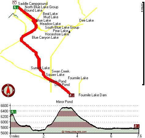
Trailhead 1 to Trailhead 2:
Total hiking length = 7.6 miles
Total climbing distance = 2.6 miles
Difficulty : Difficult
Casual Hiking Pace: 6.5 hours
Fast Hiking Pace: 3.5 hours

Trailhead 2 to Trailhead 1:
Total hiking length = 7.6 miles
Total climbing distance = 3.5 miles
Difficulty : Difficult
Casual Hiking Pace: 7 hours
Fast Hiking Pace: 4 hours
    Trailhead 1 back to Trailhead 1:
Total hiking length = 15.2 miles
Total climbing distance = 6.1 miles
Difficulty : Difficult
Casual Hiking Pace: 2 days
Fast Hiking Pace: 8.5 hours

Trailhead 2 back to Trailhead 2:
Total hiking length = 15.2 miles
Total climbing distance = 6.1 miles
Difficulty : Difficult
Casual Hiking Pace: 2 days
Fast Hiking Pace: 8.5 hours

Total elevation difference: 925 feet


Lithia Springs Resort And Gardens, Ashland
25 miles away
Hello, from Ashland, Oregon! Imagine, at the end of a long day's travel, relaxing in a 2 person whirlpool filled with hot mineral water, right in your own room. Lay back, Let the relaxing quality of t...
  
Windmill Inn And Suites Of Ashland, Ashland
31 miles away
The resort offers all the amenities of a big city hotel with the warm feeling of a country inn. All of the guest rooms are comfortable and nicely equipped to create a relaxing atmosphere. The hotel fe...
User input for Blue Rock Trail, Southern Cascade Range, Klamath County, Oregon:

Submit Input:
Your Name:
Write or Paste Input here:

Upload picture:      Review Guidelines


Outdoors Recreation Near Klamath Falls, Oregon
Very comprehensive list of a variety of outdoors recreation in the vicinity of Klamath Falls, Oregon, the metro area neareast to Blue Rock Trail. Find info on campgrounds, hiking trails, ski resorts, lakes, beaches, parks, whitewater and more.

Current weather conditions at Blue Rock Trail, Southern Cascade Range, Klamath County, Oregon
WXPort

Local climate location: PROSPECT 3 miles away

Holiday Inn Express Hotel & Suites Ashland, Or, Ashland
31 miles away
The Holiday Inn Express Hotel & Suites Ashland features a warm, elegant environment. Conveniently placed near all of Ashland's attractions, you will be sure to make your stay a yearly tradition wheth...

Ashland Super 8 Motel, Ashland
32 miles away
Super 8 Motel Ashland, Oregon is AAA Approved, 2 Diamonds, convenient to I-5 adjacent Exit 14. We Have Wireless High Speed Internet, An Indoor Heated Pool, SuperStart breakfast, Micro-Fridges, Cable ...

More Hotels and Campgrounds Near Blue Rock Trail, Southern Cascade Range, Klamath County, Oregon

OTHER_INFO
  Southern Cascade Range Campgrounds
Complete list of all the campgrounds in the Southern Cascade Range.

Southern Cascade Range Outdoors Info
Complete outdoors info for the Southern Cascade Range.

Oregon Hiking Trails
Complete list of all hiking trails in Oregon

Books about hiking trails in Oregon
List of books available on Amazon.com about hiking trails in Oregon.

Oregon Outdoors Index
This is a very comprehensive index of outdoors activities in the great state of Oregon.


TOPO
High quality water resistant topo map of Blue Rock Trail, Southern Cascade Range, Klamath County, Oregon.

OUTDOORS_GUIDE
These outdoors activities are available near Blue Rock Trail.
 Trails Near Blue Rock Trail:
Twin Ponds Trail, Klamath County County , 1 miles away, 5.1 hiking miles, 1377 feet elevation difference
Blue Canyon Trail, Klamath County County , 1 miles away,  10 hiking miles, 763 feet elevation difference
Cat Hill Way, Jackson County County , 2 miles away, 4.5 hiking miles, 2014 feet elevation difference
South Fork Trail, Klamath County County , 3 miles away, 7.4 hiking miles, 1813 feet elevation difference
Four Mile Lake Trail, Klamath County County , 3 miles away,  7.4 hiking miles, 434 feet elevation difference
Crater Trail, Jackson County County , 4 miles away,  4.4 hiking miles, 2571 feet elevation difference
Mount McLoughlin Trail, Klamath County County , 4 miles away,  14 hiking miles, 4813 feet elevation difference
 Camp Grounds Near Blue Rock Trail:
Saddle Campground, Jackson County, 2 miles away
Upper South Fork Campground, Jackson County, 6 miles away
Hemlock Lake Campground, Klamath County, 7 miles away
White Pine Campground, Klamath County, 7 miles away
Willow Lake Resort, Butte Falls, 12 miles away
 Whitewater Near Blue Rock Trail:
Rogue River - North Fork, Jackson County County , 21 miles away, Class IV(V+) - 3.3 miles long (Mill Creek Falls to Lost Creek Lake)
Rogue River - North Fork, Jackson County County , 21 miles away, Class III - 6 miles long (River Bridge to North Fork Park)
Jenny Creek, Jackson / Siskiyou County County , 24 miles away, Class IV-V+ - 14 miles long (Ashland Oregon to Iron Gate Reservoir California)
Big Butte Creek, Jackson County County , 24 miles away, Class III-IV - 9.5 miles long (Butte Falls to Netherlands Road)
Rogue River - North Fork, Jackson County County , 24 miles away, Class IV - 3 miles long (Natural Bridge to Woodruff Bridge)
 National Parks Near Blue Rock Trail:
Crater Lake National Park, Crater Lake - OR , 23 miles away
Lava Beds National Monument, Tulelake - CA , 62 miles away
 Hotels Near Blue Rock Trail:
Lithia Springs Resort And Gardens, Ashland , 25 miles away
Windmill Inn And Suites Of Ashland, Ashland , 31 miles away
Holiday Inn Express Hotel & Suites Ashland, Or, Ashland , 31 miles away
Ashland Super 8 Motel, Ashland , 32 miles away
Ashland Springs Hotel, Ashland , 34 miles away
 Lakes Near Blue Rock Trail
Horseshoe Lake, Klamath County , 1 miles away
Blue Canyon Lake, Jackson County , 1 miles away

Outdoors related information copyright © Stratus-Pikpuk, Inc. - Detailed hotel information copyright © Interactive Hotel Solutions