| |
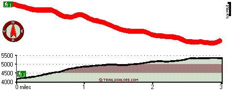
This trek shouldn't take more than 5 hours, but you never know stuff could go wrong and you could get stuck so be prepared for that. This is not a very long wilderness trail but you should still bring some emergency supplies just in case something happens. Bingham Ridge Trail stays roughly within the same elevation zone the whole time which means the conditions are about the same from start to finish. Being 6 miles long it's a mid length backcountry walk. There is only one trailhead, so you're looking at an in and out walk. At parts of the year this neighborhood sees very little rain, so make sure you check current conditions and fire restrictions with local forest authorities before you head out. The total elevation difference for Bingham Ridge Trail is 1,458 feet which is about average.
|
Total in and out hiking length = 6 miles
Total climbing distance = 2.1 miles
Difficulty : Difficult
Casual Hiking Pace:
5 hours
Fast Hiking Pace:
3 hours
Total elevation difference: 1458 feet
|


