| |
Bieberstedt Trail has a total elevation difference of 1,353 feet, and that is about average. This backpacking trail has two trailheads which means you have the option of backcountry hiking it one way if you have someone to pick you up at the other end. Even though this is not a very long backpacking and hiking trail it's always glorious to bring some emergency supplies, you never know what could happen. Bieberstedt Trail stays roughly within the same elevation zone the whole time, so you get pretty much the same conditions along the whole hiking trail. This vicinity does get very dry sometimes, so don’t forget to check for any current fire restrictions before you go. The time needed for this hike is roughly 3.5 hours, but of course some people walk a bit slower and some a bit faster. Bieberstedt Trail is 3.8 miles long it's a shorter type walk.
|
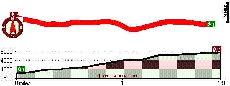
Trailhead 1 to Trailhead 2:
Total hiking length = 1.9 miles
Total climbing distance = 1.5 miles
Difficulty : Medium
Casual Hiking Pace:
2 hours
Fast Hiking Pace:
1 hours
Trailhead 2 to Trailhead 1:
Total hiking length = 1.9 miles
Total climbing distance = 0 miles
Difficulty : Easy
Casual Hiking Pace:
1 hours
Fast Hiking Pace:
.5 hours
| | Trailhead 1 back to Trailhead 1:
Total hiking length = 3.8 miles
Total climbing distance = 1.5 miles
Difficulty : Medium
Casual Hiking Pace:
3.5 hours
Fast Hiking Pace:
2 hours
Trailhead 2 back to Trailhead 2:
Total hiking length = 3.8 miles
Total climbing distance = 1.5 miles
Difficulty : Medium
Casual Hiking Pace:
3.5 hours
Fast Hiking Pace:
2 hours
|
Total elevation difference: 1353 feet
|


