| |
The total elevation difference for this hiking trail is 1,635 feet which is about average. Bessie Rock Trail is not that long but you should still bring some emergency supplies just in case something happens. This great outdoors trail sometimes gets very dry, so make sure you check current conditions and fire restrictions with local forest authorities before you head out. Bessie Rock Trail has only one trailhead, so in and out is the way to backcountry walk it normally. Being 1.6 miles long it's shorter than many backpacking and hiking trails. You should count on this backcountry walk taking about 1.5 hours, but you never know stuff could go wrong and you could get stuck so be prepared for that. Some parts of this backpacking and hiking trail are much higher up than other parts of the backpacking and hiking trail which of course means you need to be prepared for different conditions on different parts of the backpacking and hiking trail.
|
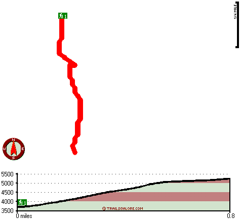
Total in and out hiking length = 1.6 miles
Total climbing distance = .6 miles
Difficulty : Medium
Casual Hiking Pace:
1.5 hours
Fast Hiking Pace:
1 hours
Total elevation difference: 1635 feet
|


