Oregon hiking trails - Beachie Trail, Central Cascade Range, Marion County

   
  Oregon is a tremendous outdoors state. If you happen to be in Oregon, why not go backcountry trekking, it never gets boring. Perfect backpacking trails in Oregon are in abundance; among these are Beachie Trail in Marion County. This backcountry walk should take you about 2 days, so it's an outstanding thing if your backpack is big enough to do the job. Beachie Trail is a one trailhead great outdoors hiking trail, so you're looking at an in and out walk. Beachie Trail is a very long hiking and backpacking trail having an average number of uphill miles which
    makes this a very tough backpacking and hiking trail for advanced hikers looking for an outstanding challenge. Keep in mind that this is a long backpacking and hiking trail, so don't forget to pack enough supplies. The high level of precipitation makes Beachie Trail a quite wet
place; most of the rain falls during December, and July meanwhile is the driest month. This is one of many backpacking and hiking trails in the surrounding region. Some parts of this hiking trail are much higher up than other parts of the hiking trail which of course means you need to be prepared for different conditions on different parts of the hiking trail. A long journey separates Portland-Vancouver-Beaverton from Beachie Trail, but backcountry backpacking along this hiking trail is very exciting. Please follow all local rules about fires and camping.  
Put on your backcountry backpacking shoes, and hit the hiking trail, Beachie Trail in Marion County, Oregon is just the site. The total elevation difference for this great outdoors hiking trail is 1,518 feet which is an average number. Each one of the many backpacking trails of Oregon is lovely in its own way. Being 13.4 miles long; it's longer than many hiking trails. Backcountry hiking trails like this one here in the Central Cascade Range are the best way to enjoy these summits. High temperatures at Beachie Trail during the summer are in the 70's. When the night sets in temperatures fall down into the 40's. Throughout the winter highs are frequently in the 40's; through the dark hours in the winter at Beachie Trail temperatures fall to the 30's.

Briefly about the general area:
And if that's not enough there's loads more entertaining stuff to do in the Central Cascade Range. If you're here at Beachie Trail, you could go to Beachie Creek, and Beachie Saddle is another splendid site to go to close by. You'll wish for more hours in a day to enjoy all the cool things at Beachie Trail. Why not check out nearby Marten Creek while you're here at Beachie Trail.
Paddling on Breitenbush River is so much fun; why not camp at Detroit Lake State Park while you're here at Beachie Trail. Camping is available at B and B Rentals, and get wet paddling on Santiam River - North. A trip to Pansy Basin revitalizes the spirit, and Terrace Spring is an inspiring site to explore while here.

Location of Trailhead: Latitude 44.7836, Longitude -122.2031
- - Directions and Road Map

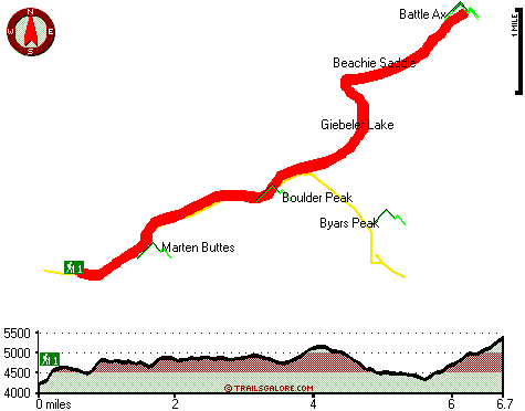
Total in and out hiking length = 13.4 miles

Total climbing distance = 6 miles

Difficulty : Difficult

Casual Hiking Pace: 2 days

Fast Hiking Pace: 8 hours

Total elevation difference: 1518 feet


Resort at the Mountain, Welches
30 miles away
The Resort at The Mountain is the premier Northwest golf and ski resort located in the Highlands of Oregon just an hour east of Portland at the western base of Mt. Hood. The Resort features 160 gues...
  
Whispering Woods (Vri), Welches
30 miles away
Whispering Woods is a resort destination east of Portland which opened in 1981 with 42 condominiums. The second phase of 24 additional condominiums opened in 1992. The resort offers a clubhouse with a...
User input for Beachie Trail, Central Cascade Range, Marion County, Oregon:

Submit Input:
Your Name:
Write or Paste Input here:

Upload picture:      Review Guidelines


Outdoors Recreation Near Portland-Vancouver-Beaverton, Oregon-Washington
Very comprehensive list of a variety of outdoors recreation in the vicinity of Portland-Vancouver-Beaverton, Oregon-Washington, the metro area neareast to Beachie Trail. Find info on campgrounds, hiking trails, ski resorts, lakes, beaches, parks, whitewater and more.

Current weather conditions at Beachie Trail, Central Cascade Range, Marion County, Oregon
WXPort

Local climate location: SCOTTS MILLS 15 miles away

Best Western Sandy Inn, Sandy
30 miles away
This Sandy, Oregon hotel is an interior corridor hotel offering guests easy access to Mt. Hood, the Rose Garden Convention Center and the Oregon Zoo at Washington Park. Enjoy beautiful mountain view...

Mount Hood Inn, Government Camp
37 miles away
At the Mount Hood Inn we offer our guests the finest accommodations on the mountain. With our modern facilities and friendly local staff we are able to give you the attention and service you have com...

More Hotels and Campgrounds Near Beachie Trail, Central Cascade Range, Marion County, Oregon

OTHER_INFO
  Central Cascade Range Campgrounds
Complete list of all the campgrounds in the Central Cascade Range.

Central Cascade Range Outdoors Info
Complete outdoors info for the Central Cascade Range.

Oregon Hiking Trails
Complete list of all hiking trails in Oregon

Books about hiking trails in Oregon
List of books available on Amazon.com about hiking trails in Oregon.

Oregon Outdoors Index
This is a very comprehensive index of outdoors activities in the great state of Oregon.


TOPO
High quality water resistant topo map of Beachie Trail, Central Cascade Range, Marion County, Oregon.

OUTDOORS_GUIDE
These outdoors activities are available near Beachie Trail.
 Trails Near Beachie Trail:
French Creek Trail, Marion County County , 2 miles away, 8.9 hiking miles, 4067 feet elevation difference
Rocky Top Trail, Marion County County , 4 miles away, 2.7 hiking miles, 526 feet elevation difference
Twin Lakes Trail, Marion County County , 5 miles away,  8.4 hiking miles, 888 feet elevation difference
Whetstone Trail, Clackamas County County , 5 miles away,  3.2 hiking miles, 1456 feet elevation difference
Mother Lode Trail, Marion County County , 6 miles away, 10.7 hiking miles, 3313 feet elevation difference
Molalla Trail, Clackamas County County , 6 miles away, 3 hiking miles, 1285 feet elevation difference
Nohorn Trail, Clackamas County County , 7 miles away, 1.9 hiking miles, 472 feet elevation difference
 Camp Grounds Near Beachie Trail:
B and B Rentals, Detroit, 1 miles away
Detroit Lake State Park, -blank-, 4 miles away
Skookum Lake Campground, Clackamas County, 10 miles away
Cascade Sports Camp, Lyons, 14 miles away
Pelton Park, Estacada, 19 miles away
 Whitewater Near Beachie Trail:
Breitenbush River, Marion County County , 7 miles away, Class IV - 8.2 miles long (Cleator Bend Campground to Detroit Lake)
Santiam River - North, Marion/ Linn County County , 8 miles away, Class III-IV - 7.3 miles long (Bruno Mt. Road Bridge to Detroit Reservoir)
Elkhorn Creek, -blank- County County , 11 miles away, Class III-V - 10 miles long (to confluence with Little North Santiam)
Santiam River - North, Marion/ Linn County County , 12 miles away, Class III-V - 4.7 miles long (Big Cliff Dam to Packsaddle Park)
Collawash River, Marion County County , 12 miles away, Class III-IV(V) - 5 miles long (Elk Lake Creek to river mile 5.5)
 Hotels Near Beachie Trail:
Resort at the Mountain, Welches , 30 miles away
Whispering Woods (Vri), Welches , 30 miles away
Best Western Sandy Inn, Sandy , 30 miles away
Mount Hood Inn, Government Camp , 37 miles away
Howard Johnson Gresham, Gresham , 38 miles away
 Lakes Near Beachie Trail
Giebeler Lake, Marion County , 2 miles away

Outdoors related information copyright © Stratus-Pikpuk, Inc. - Detailed hotel information copyright © Interactive Hotel Solutions