Oregon hiking trails - Anderson Ridge Trail, Central Cascade Range, Linn County

   
  You'll need to go far from Bend to get to Anderson Ridge Trail, but it is a perfect backpacking trail. There are so many delightful wilderness trails for backcountry hiking in Oregon, and Anderson Ridge Trail in Linn County is one of them. This part of Oregon has a glorious deal of available outdoors pursuits. Anderson Ridge Trail is 15 miles long; it's a long trail. This trail goes through some very different elevations, and that means that some parts of the trail could be very different from other parts of it. This is one of many hiking trails in the
    surrounding neighborhood. Hiking trails like this one here in the Central Cascade Range are a glorious way to explore these mountains. Anderson Ridge Trail has a total elevation difference of 2,720 feet which is a higher than average number. There are numerous wilderness trails
in Oregon, and each one has its own character. When you're here in Oregon backcountry hiking along one of its wilderness trails is something that is always fun to do. This region does get very dry sometimes, so don’t forget to check for any current fire restrictions before you go. Now, this is roughly a 2-day backcountry trek, so better have big backpack to fit all the stuff you need. At Anderson Ridge Trail throughout the summer months highs are in the 80's with night lows in the 40's. During the winter highs are in the 30's, and winter nights come  
with lows in the 20's to Anderson Ridge Trail. The length of this wilderness hiking trail is on the longer side with an average amount of climbing distance which makes it an outstanding hiking trail for experienced backcountry trekkers in great shape. And keep in mind that there could be temporary safety restrictions in place. There are two trailheads to chose from, one in each end which means you have the option of backpacking it one way if you have someone to pick you up at the other end. You can't spend all your time indoors you need to get out once in a while, and if you happen to be in Linn County of Oregon, Anderson Ridge Trail is a perfect local backpacking trail for doing a bit of leg stretching. The high level of precipitation makes Anderson Ridge Trail a relatively wet place; through the month of December you get the most rain around here while July is commonly the driest month. Now this backcountry trail is pretty long, so do pack enough food to last the whole trip.

Briefly about the general area:
These mountains rock, just check out all the cool things to do in the Central Cascade Range. Tombstone Prairie Campground is a great campground nearby. Stay the night at Country Star Recreational Vehicle Park, and hey, Bobby Creek is a good local stream.
A short trip to Tamolitch Falls is always worthwhile, and Smith Prairie is a great place to stretch your legs a bit. A pleasant journey to Fingerboard Prairie is a good way to spend an afternoon, and Willamette National Forest is a forest that you can go to. Be careful coming to Anderson Ridge Trail, you might not ever wanna return back home again. A tour to Anderson Ridge Trail wouldn't be complete without taking a look at Icecap Spring, and Marion Creek has a wonderful whitewater paddling spot close by.
If you want a good time in the great outdoors just come on up to the Central Cascade Range. If you don’t have a problem getting soaked, you can always go whitewater paddling on Horse Creek; some of the water close by flows, like Ice Cap Creek.

Location of Trailhead 1: Latitude 44.2828, Longitude -122.0398
- - Directions and Road Map

Location of Trailhead 2: Latitude 44.2923, Longitude -121.9534
- - Directions and Road Map


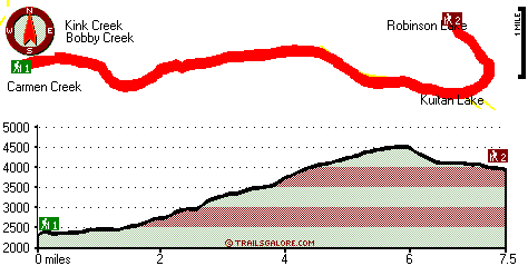
Trailhead 1 to Trailhead 2:
Total hiking length = 7.5 miles
Total climbing distance = 4.8 miles
Difficulty : Difficult
Casual Hiking Pace: 7.5 hours
Fast Hiking Pace: 4.5 hours

Trailhead 2 to Trailhead 1:
Total hiking length = 7.5 miles
Total climbing distance = 1.3 miles
Difficulty : Difficult
Casual Hiking Pace: 5.5 hours
Fast Hiking Pace: 3 hours
    Trailhead 1 back to Trailhead 1:
Total hiking length = 15 miles
Total climbing distance = 6.1 miles
Difficulty : Difficult
Casual Hiking Pace: 2 days
Fast Hiking Pace: 8.5 hours

Trailhead 2 back to Trailhead 2:
Total hiking length = 15 miles
Total climbing distance = 6.1 miles
Difficulty : Difficult
Casual Hiking Pace: 2 days
Fast Hiking Pace: 8.5 hours

Total elevation difference: 2720 feet


Lodge at Suttle Lake, Sisters
24 miles away
We are not your typical hotel. Nestled in the heart of the Deschutes National Forest amid soaring pines. Suttle Lake Resort provides an enchanted escape. Our resorts mountain views and pristine lake w...
  
Best Western Ponderosa Lodge, Sisters
30 miles away
Offers a refreshing environment with renovated rooms, new deluxe suites and smoke-free accommodations. The perfect choice while traveling the 'Gateway to the Cascades', ideally located on 14 acres sur...
User input for Anderson Ridge Trail, Central Cascade Range, Linn County, Oregon:

Submit Input:
Your Name:
Write or Paste Input here:

Upload picture:      Review Guidelines


Outdoors Recreation Near Bend, Oregon
Very comprehensive list of a variety of outdoors recreation in the vicinity of Bend, Oregon, the metro area neareast to Anderson Ridge Trail. Find info on campgrounds, hiking trails, ski resorts, lakes, beaches, parks, whitewater and more.

Current weather conditions at Anderson Ridge Trail, Central Cascade Range, Linn County, Oregon
WXPort

Local climate location: BELKNAP SPRINGS 5 miles away

Five Pine Lodge, Sisters
31 miles away
Lodging in Sisters, Oregon, at FivePine Lodge and Spa is a vacation back in time to Central Oregon's golden era of travel with every modern luxury. Whether you're practicing Tai-Chi atop Eagle Rock, p...

Sunriver Resort, Sunriver
43 miles away
Sunriver Resort is located at the foot of the Cascade Mountain range in Central Oregon- 15 miles south of Bend. A four-star- full-service resort for family- couples and business. Offering world-class ...

More Hotels and Campgrounds Near Anderson Ridge Trail, Central Cascade Range, Linn County, Oregon

OTHER_INFO
  Central Cascade Range Campgrounds
Complete list of all the campgrounds in the Central Cascade Range.

Central Cascade Range Outdoors Info
Complete outdoors info for the Central Cascade Range.

Oregon Hiking Trails
Complete list of all hiking trails in Oregon

Books about hiking trails in Oregon
List of books available on Amazon.com about hiking trails in Oregon.

Oregon Outdoors Index
This is a very comprehensive index of outdoors activities in the great state of Oregon.


TOPO
High quality water resistant topo map of Anderson Ridge Trail, Central Cascade Range, Linn County, Oregon.

OUTDOORS_GUIDE
These outdoors activities are available near Anderson Ridge Trail.
 Trails Near Anderson Ridge Trail:
Deer Butte Trail, Linn County County , 3 miles away, 8.6 hiking miles, 814 feet elevation difference
Smith Prairie Trail, Linn County County , 4 miles away, 8.6 hiking miles, 923 feet elevation difference
Benson Trail, Lane County County , 5 miles away,  8.4 hiking miles, 1312 feet elevation difference
Browder Ridge Trail, Linn County County , 7 miles away, 3.6 hiking miles, 1658 feet elevation difference
Pocket Way, Linn County County , 8 miles away,  3.2 hiking miles, 166 feet elevation difference
Patjens Lakes Trail, Linn County County , 8 miles away, 5.6 hiking miles, 480 feet elevation difference
Hand Lake Trail, Lane County County , 8 miles away,  4 hiking miles, 224 feet elevation difference
 Camp Grounds Near Anderson Ridge Trail:
Tombstone Prairie Campground, Linn County, 11 miles away
Country Star Recreational Vehicle Park, Foster, 12 miles away
Patio RV Park, Blue River, 15 miles away
Holiday Farm RV Resort, Blue River, 17 miles away
Echo Campground, Lane County, 18 miles away
 Whitewater Near Anderson Ridge Trail:
Horse Creek, Lane County County , 10 miles away, Class III - 11 miles long (above Separation Creek to McKenzie River)
Marion Creek, Linn County County , 16 miles away, Class IV(V) - 7 miles long (Gooch Falls)
Blue River, Linn/ Lane County County , 17 miles away, Class IV-V - 4 miles long (Quentin Creek to Blue River Reservoir)
Lookout Creek, -blank- County County , 18 miles away, Class III-IV - 2.5 miles long (2.5 miles above Blue River to Blue River)
McKenzie River - South Fork, Lane County County , 19 miles away, Class III-IV - 6.2 miles long (Dutch Oven Camp to Cougar Reservoir)
 National Parks Near Anderson Ridge Trail:
Crater Lake National Park, Crater Lake - OR , 69 miles away
 Hotels Near Anderson Ridge Trail:
Lodge at Suttle Lake, Sisters , 24 miles away
Best Western Ponderosa Lodge, Sisters , 30 miles away
Five Pine Lodge, Sisters , 31 miles away
Sunriver Resort, Sunriver , 43 miles away
The Pines at Sunriver, Sunriver , 44 miles away
 Lakes Near Anderson Ridge Trail
Kuitan Lake, Linn County , 3 miles away
Smith Reservoir, Linn County , 4 miles away

Outdoors related information copyright © Stratus-Pikpuk, Inc. - Detailed hotel information copyright © Interactive Hotel Solutions