| |
|
| | The Alpine Trail is widely know to be a popular Mountain Bike trail. Hikers should expect to see mountain bikes on their journey. The trail is open to all users (Hikers, Mountain Bikes, Horses and Motorcycles). Also this is only the lower part of the Alpine Trail. Says Benjamin
During summer months Alpine trail is ridden by thousands of people on mountain bikes. Says John
Alpine Trail is positioned a rather lengthy journey from Eugene-Springfield, but trekking it is glorious enjoyment any time. Going for a backcountry walk here in Oregon is a |
|
perfect way to spend some time. Ok, you've been cooped up too long, time to get out in the fresh air a bit, and Alpine Trail in Lane County, Oregon is just the site. These wilderness trails here in the Central Cascade Range are the best way to enjoy these mountaintops. With its
| | 10.2 miles of walking distance; it's a long wilderness hiking trail. This is one of many backpacking trails in the surrounding region. Summertime highs at Alpine Trail generally tend to be in the 80's, and through the night it cools down to the 50's. High temperatures through the winter are normally in the 40's, and night lows through the winter for Alpine Trail tend to be in the 30's. A visit to Oregon is not complete without some trekking. There are numerous backcountry hiking trails in Oregon, and each one has something unique to offer. This is a two-ended | |
|
wilderness trail with two trailheads, so if you can get a ride from someone, you can backcountry hike it just one way. Don’t forget to check for any current restrictions or closures before you go. Alpine Trail generally gets lots of rainfall; throughout the month of November you
get the most rain around here, and July meanwhile is the driest month. The length of Alpine Trail is on the longer side having an average number of uphill miles which makes this backpacking trail glorious for hard core backpackers looking for adventure. Backpacking and hiking trails
for hiking, and backpacking can be found all over Oregon, and Alpine Trail in Lane County is one of them. Alpine Trail has a total elevation difference of 2,291 feet which is an average number. Some parts of this wilderness hiking trail are much higher up than other parts of the
wilderness hiking trail, and that means that some parts of the wilderness hiking trail could be very different from other parts of it. This is a great outdoors hiking trail that is quite long, so make sure you bring plenty of supplies. This great outdoors hiking trail sometimes
gets very dry, so don’t forget to check for any current fire restrictions before you go. You should count on this hike taking about 9 hours, but you never know stuff could go wrong and you could get stuck so be prepared for that.
Briefly about the general area: A pleasant
trip to High Prairie is a delightful way to spend an afternoon, and you can stay the night at Errin Campground. Get yourself into a kayak and hit Willamette River - Middle Fork, and since you're here, you could have a look at McLane Creek. That right there is heaps of exciting
things already but it goes on, the Central Cascade Range has it all. It's a great idea to stop at Short Creek, it's in the neighborhood of Alpine Trail; of course, A trip to Windy Pass is always fun. You'll need more than a day to discover everything Alpine Trail has to offer,
you can camp at Casey's Riverside Park, and if you come at the right time of year, Willamette River - North Fork of Middle Fork offers some wonderful whitewater. Any time is a wonderful time at Alpine Trail if you fancy the outdoors.
|
|
Location of Trailhead 1: Latitude 43.7767, Longitude -122.4974 - - Directions and Road Map
Location of Trailhead 2: Latitude 43.8375, Longitude -122.4838 - - Directions and Road Map

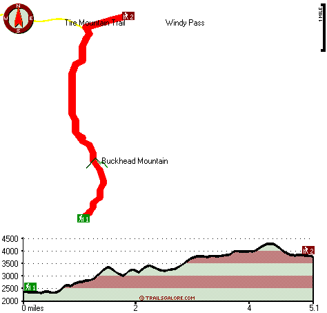
Trailhead 1 to Trailhead 2: Total hiking length = 5.1 miles Total climbing distance = 2.6 miles Difficulty : Medium Casual Hiking Pace:
5 hours
Fast Hiking Pace:
2.5 hours
Trailhead 2 to Trailhead 1: Total hiking length = 5.1 miles Total climbing distance = 1.7 miles Difficulty : Medium Casual Hiking Pace:
4 hours
Fast Hiking Pace:
2.5 hours
| | Trailhead 1 back to Trailhead 1: Total hiking length = 10.2 miles Total climbing distance = 4.3 miles Difficulty : Difficult Casual Hiking Pace:
9 hours
Fast Hiking Pace:
6 hours
Trailhead 2 back to Trailhead 2: Total hiking length = 10.2 miles Total climbing distance = 4.3 miles Difficulty : Difficult Casual Hiking Pace:
9 hours
Fast Hiking Pace:
6 hours
|
Total elevation difference: 2291 feet

Best Western Oakridge Inn, Oakridge
|
3 miles away
This Oakridge, Oregon hotel offers a complimentary continental breakfast each morning and convenient access to a variety of outdoor activities. Discover the Best Western Oakridge Inn, nestled agains...
|
| |
Comfort Inn & Suites Creswell, Creswell
|
36 miles away
Welcome to the Comfort Inn and Suites of Creswell. This hotel is close to a golf course and is within walking distance of shops and restaurants. We are just a short drive to rivers, lakes and other ou...
|
|
User input for Alpine Trail, Central Cascade Range, Lane County, Oregon:

Outdoors Recreation Near Eugene-Springfield, Oregon Very comprehensive list of a variety of outdoors recreation in the vicinity of Eugene-Springfield, Oregon, the metro area neareast to Alpine Trail. Find info on campgrounds, hiking trails, ski resorts, lakes, beaches, parks, whitewater and more.
|
Current weather conditions at Alpine Trail, Central Cascade Range, Lane County, Oregon

Local climate location: LOOKOUT POINT DAM 13 miles away

           
| |
Super 8 Creswell/South Eugene, Creswell
|
36 miles away
Conveniently located on I-5 at Exit, 182, our Super 8 is AAA approved. We have a friendly staff and are also Pet Friendly. We offer a SuperStart Breakfast, Free High Speed Wirelless Internet, an Out...
|
Village Inn, Springfield
|
37 miles away
The Village Inn Springfield Oregon is your ideal choice for Springfield Oregon hotels. The Village Inn provides lodging near the University of Oregon, Autzen Stadium, Downtown Eugene and just blocks a...
|
|
More Hotels and Campgrounds Near Alpine Trail, Central Cascade Range, Lane County, Oregon
| |
| |
 |
|
| These outdoors activities are available near Alpine Trail. |
| | Trails Near Alpine Trail:
 |
Tire Mountain Trail, Lane County
County
, 2 miles away, 2.4 hiking miles, 722 feet elevation difference |
 |
McKinley Creek Trail, Lane County
County
, 3 miles away, 4.3 hiking miles, 1580 feet elevation difference |
 |
Cain Cabin Trail, Lane County
County
, 4 miles away, 3.6 hiking miles, 2516 feet elevation difference |
 |
Cloverpatch Trail, Lane County
County
, 4 miles away, 3.3 hiking miles, 1327 feet elevation difference |
 |
Cabin Creek Trail, Lane County
County
, 5 miles away, 2.1 hiking miles, 1792 feet elevation difference |
 |
Sourgrass Trail, Lane County
County
, 5 miles away, 1.8 hiking miles, 911 feet elevation difference |
 |
Larison Creek Trail, Lane County
County
, 5 miles away, 1.6 hiking miles, 191 feet elevation difference |
|
| | Whitewater Near Alpine Trail:
 |
Willamette River - Middle Fork, Lane County
County
, 2 miles away, Class II - 12.5 miles long (Hills Creek Dam to Lookout Point Reservoir) |
 |
Willamette River - North Fork of Middle Fork, Lane County
County
, 6 miles away, Class IV-V - 13.5 miles long (to Westfir) |
 |
Salmon Creek, Lane County
County
, 7 miles away, Class II-V - 12 miles long (Top of Upper Salmon Creek Gorge to Oakridge) |
 |
Salt Creek, Lane County
County
, 11 miles away, Class III-IV - 7.2 miles long (McCredie Hot Springs to Rigdon Road Bridge) |
 |
Fall Creek, Lane County
County
, 12 miles away, Class III-IV - 8 miles long (Portland Creek to Fall Creek Reservoir) |
|
| | Hotels Near Alpine Trail:
 |
Best Western Oakridge Inn, Oakridge
, 3 miles away |
 |
Comfort Inn & Suites Creswell, Creswell
, 36 miles away |
 |
Super 8 Creswell/South Eugene, Creswell
, 36 miles away |
 |
Village Inn, Springfield
, 37 miles away |
 |
Village Green Resort, Cottage Grove
, 38 miles away |
|
|
|
 |
|