| |
The total elevation difference for this great outdoors trail is 1,237 feet which is about average. There are two trailheads to chose from, one in each end which means you have the option of backcountry hiking it one way if you have someone to pick you up at the other end. This trek should take you about 3.5 days, so better have big a backpack to fit all the stuff you need. At parts of the year this area sees very little rain, so make sure you check current conditions and fire restrictions with local forest authorities before you head out. Being 23 miles long; it's a long backcountry hiking trail. The backcountry hiking trail stays roughly within the same elevation zone the whole time, so you get pretty much the same conditions along the whole backcountry hiking trail. This is a trail that is quite long, so don't forget to pack enough supplies.
|
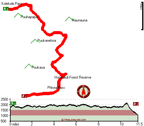
Trailhead 1 to Trailhead 2:
Total hiking length = 11.5 miles
Total climbing distance = 5.3 miles
Difficulty : Difficult
Casual Hiking Pace:
1.5 days
Fast Hiking Pace:
6 hours
Trailhead 2 to Trailhead 1:
Total hiking length = 11.5 miles
Total climbing distance = 5.7 miles
Difficulty : Difficult
Casual Hiking Pace:
2 days
Fast Hiking Pace:
6 hours
| | Trailhead 1 back to Trailhead 1:
Total hiking length = 23 miles
Total climbing distance = 11 miles
Difficulty : Difficult
Casual Hiking Pace:
3.5 days
Fast Hiking Pace:
2.5 days
Trailhead 2 back to Trailhead 2:
Total hiking length = 23 miles
Total climbing distance = 11 miles
Difficulty : Difficult
Casual Hiking Pace:
3.5 days
Fast Hiking Pace:
2.5 days
|
Total elevation difference: 1237 feet
|


