California hiking trails - Yosemite Falls Trail, Central Sierra Nevada, Mariposa County

   
  Hiking trails are fine and plentiful in California, and one of those is Yosemite Falls Trail in Mariposa County. California is a perfect outdoors state. Going for a trek here in California is an excellent way to spend some time. Please follow all local rules about fires and camping. Through the summertime highs here at Yosemite Falls Trail get into the 80's with nighttime lows in the 50's. The winter brings highs down to the 40's while Yosemite Falls Trail nighttime low temperatures during the winter are in the 20's. This wilderness hiking trail has only one
    trailhead, so in and out is the way to backcountry walk it normally. You should count on this backcountry hike taking about 8 hours, but of course some people walk a bit slower and some a bit faster. These great outdoors hiking trails here in the Central Sierra Nevada are the best
way to enjoy these hills. Yosemite Falls Trail is not very close to Madera at all, but it is an enjoyable site to hike. Yosemite Falls Trail is a relatively wet place mostly with much rain; most of the rain falls during January, and the driest month is July. With its 9.4 miles of walking distance; it's a long backpacking trail. Yosemite Falls Trail has a total elevation difference of 3,958 feet, and that is higher than average. Gotta get out of the settlement man, and if you happen to be in Mariposa County of California, Yosemite Falls Trail is a wonderful  
local wilderness trail for doing a bit of leg stretching. Different parts of this backpacking trail are at very different elevations, so keep in mind that you may need to dress differently at different elevations. Now this great outdoors hiking trail is pretty long, so do pack enough food to last the whole trip. This is just one of a large number of backpacking and hiking trails in this neighborhood. At parts of the year this vicinity sees very little rain, so make sure you check current conditions and fire restrictions with local forest authorities before you head out. The length of Yosemite Falls Trail is on the longer side having an average number of uphill miles which makes it a nice backpacking and hiking trail for experienced hikers in pleasant shape. There are numerous great outdoors trails in California, and each one has its own character.

Briefly about the general area:
Yosemite Creek is a stream that you may stumble upon while here, and Eagle Peak Meadows is a delightful place any time of year. A short visit to Lower Yosemite Fall is always worthwhile; whitewater paddling is not for everyone but if it's for you then, we recommend Yosemite Creek.
Yeah, come here to Yosemite Falls Trail for a magnificent time. You'll need more than a day to explore everything Yosemite Falls Trail has to offer, you can camp at Lower River Campground, and Sentinel Creek is one of the streams nearby that might be worth checking out. So many fun things to do in the Central Sierra Nevada, not sufficient time. There's whitewater on Merced River for all you adrenaline kick people. There's so much to do here at Yosemite Falls Trail that you need to camp here for a while, Upper River Campground is a delightful site for that.
Don't miss out on a trip to Yosemite National Park while you're here at Yosemite Falls Trail, and a tour to Yosemite Falls Trail wouldn't be complete without taking a look at Upper Yosemite Falls. This place, the Central Sierra Nevada, has so much outdoors cool things. Nearby Indian Canyon is a wonderful location to go if you're at Yosemite Falls Trail, and a pleasant visit to Leidig Meadow is a brilliant way to spend an afternoon.

Location of Trailhead: Latitude 37.7415, Longitude -119.6019
- - Directions and Road Map

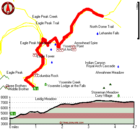
Total in and out hiking length = 9.4 miles

Total climbing distance = 3.7 miles

Difficulty : Difficult

Casual Hiking Pace: 8 hours

Fast Hiking Pace: 5 hours

Total elevation difference: 3958 feet


Wawona Hotel, Yosemite National Park
5 miles away
Wawona is one of the oldest mountain resort hotels in California and a National Historic Landmark. Its verdant meadows, rushing streams, and tranquility make this a favorite of those who prefer a rela...
  
Yosemite Lodge at the Falls, Yosemite National Park
5 miles away
As the closest property to Yosemite Falls, Yosemite Lodge is an idyllic spot for families, group retreats and visitors seeking to blend the comforts of a hotel while exploring the wilderness. In 1998,...
User input for Yosemite Falls Trail, Central Sierra Nevada, Mariposa County, California:

Submit Input:
Your Name:
Write or Paste Input here:

Upload picture:      Review Guidelines


Outdoors Recreation Near Madera, California
Very comprehensive list of a variety of outdoors recreation in the vicinity of Madera, California, the metro area neareast to Yosemite Falls Trail. Find info on campgrounds, hiking trails, ski resorts, lakes, beaches, parks, whitewater and more.

Current weather conditions at Yosemite Falls Trail, Central Sierra Nevada, Mariposa County, California
WXPort

Local climate location: CHERRY VALLEY DAM 9 miles away

Housekeeping Camp, Yosemite National Park
5 miles away
Housekeeping Camp is located along a section of the Merced River in the center of Yosemite Valley. This is the ideal location for those who like to camp outdoors without the bother of setting up a ten...

Curry Village, Yosemite National Park
5 miles away
The largest lodging facility in Yosemite Valley, Curry Village offers a motel, cabins with and without private bathrooms, and canvas tent cabins without plumbing. Although Curry Village is the largest...

More Hotels and Campgrounds Near Yosemite Falls Trail, Central Sierra Nevada, Mariposa County, California

OTHER_INFO
  Central Sierra Nevada Campgrounds
Complete list of all the campgrounds in the Central Sierra Nevada.

Central Sierra Nevada Outdoors Info
Complete outdoors info for the Central Sierra Nevada.

California Hiking Trails
Complete list of all hiking trails in California

Books about hiking trails in California
List of books available on Amazon.com about hiking trails in California.

California Outdoors Index
This is a very comprehensive index of outdoors activities in the great state of California.


TOPO
High quality water resistant topo map of Yosemite Falls Trail, Central Sierra Nevada, Mariposa County, California.

OUTDOORS_GUIDE
These outdoors activities are available near Yosemite Falls Trail.
 Trails Near Yosemite Falls Trail:
Eagle Peak Trail, Mariposa County , 1 miles away,  9.4 hiking miles, 3939 feet elevation difference
Four Mile Trail, Mariposa County , 2 miles away, 3.7 hiking miles, 3869 feet elevation difference
North Dome Trail, Mariposa County , 2 miles away, 14.4 hiking miles, 4985 feet elevation difference
Hetch Hetchy Trail, Mariposa County , 2 miles away, 7.7 hiking miles, 3804 feet elevation difference
Buena Vista Trail, Madera County , 3 miles away,  22.4 hiking miles, 2797 feet elevation difference
Panorama Trail, Mariposa County , 3 miles away, 7.1 hiking miles, 3896 feet elevation difference
Mist Trail, Mariposa County , 4 miles away,  2.8 hiking miles, 1214 feet elevation difference
 Camp Grounds Near Yosemite Falls Trail:
Lower River Campground, Mariposa County, 2 miles away
Upper River Campground, Mariposa County, 2 miles away
Lower Pines Campground, Mariposa County, 2 miles away
North Pines Campground, Mariposa County, 2 miles away
Upper Pines Campground, Mariposa County, 3 miles away
 Whitewater Near Yosemite Falls Trail:
Yosemite Creek, Mariposa County County , 3 miles away, Class IV-V - 8 miles long (Tioga Pass Road to Yosemite Falls)
Merced River, Mariposa County County , 7 miles away, Class V - 4.8 miles long (Routes 120-140 Junction to Arch Rock Entrance Station)
Tenaya Creek, Mariposa County County , 8 miles away, Class V - 1 miles long (Super Slide)
Tuolumne River, Tuolumne County County , 9 miles away, Class IV-V+ - 32 miles long (Tioga Road Bridge to Hetch Hetchy Reservoir)
Merced River - South Fork, Mariposa County County , 12 miles away, Class V+ - 16 miles long (Upper)
 National Parks Near Yosemite Falls Trail:
Yosemite National Park, Yosemite National Park - CA , 10 miles away
Devils Postpile National Monument, Mammoth Lakes - CA , 60 miles away
 Hotels Near Yosemite Falls Trail:
Wawona Hotel, Yosemite National Park , 5 miles away
Yosemite Lodge at the Falls, Yosemite National Park , 5 miles away
Housekeeping Camp, Yosemite National Park , 5 miles away
Curry Village, Yosemite National Park , 5 miles away
Ahwahnee Hotel, Yosemite National Park , 5 miles away
 Lakes Near Yosemite Falls Trail
El Capitan Meadow, Mariposa County , 3 miles away
Mirror Lake, Mariposa County , 3 miles away

Outdoors related information copyright © Stratus-Pikpuk, Inc. - Detailed hotel information copyright © Interactive Hotel Solutions