| |
The total elevation difference for this backcountry trail is 1,394 feet which is an average number. There's not much difference in elevation along the backpacking and hiking trail, so you get pretty much the same conditions along the whole backpacking and hiking trail. This vicinity does get very dry sometimes, so do check for current fire restrictions before you go if you plan to bring a stove or make a camp fire. This backcountry trail has two trailheads, so hiking it one way is an option if you can arrange for a ride back. Even though this is not a very long wilderness trail you should still bring some emergency supplies just in case something happens. Yerba Buena Trail is 3.2 miles long it's shorter than many backpacking and hiking trails. The time needed for this trek is roughly 3 hours, but you never know stuff could go wrong and you could get stuck so be prepared for that.
|
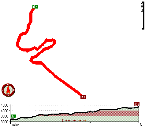
Trailhead 1 to Trailhead 2:
Total hiking length = 1.6 miles
Total climbing distance = 1 miles
Difficulty : Medium
Casual Hiking Pace:
1.5 hours
Fast Hiking Pace:
1 hours
Trailhead 2 to Trailhead 1:
Total hiking length = 1.6 miles
Total climbing distance = .4 miles
Difficulty : Easy
Casual Hiking Pace:
1 hours
Fast Hiking Pace:
.5 hours
| | Trailhead 1 back to Trailhead 1:
Total hiking length = 3.2 miles
Total climbing distance = 1.4 miles
Difficulty : Medium
Casual Hiking Pace:
3 hours
Fast Hiking Pace:
2 hours
Trailhead 2 back to Trailhead 2:
Total hiking length = 3.2 miles
Total climbing distance = 1.4 miles
Difficulty : Medium
Casual Hiking Pace:
3 hours
Fast Hiking Pace:
2 hours
|
Total elevation difference: 1394 feet
|


