| |
With its 11.4 miles of walking distance; it's considered a longer hike. Now, this is roughly a 1.5-day hike, so it's a splendid thing if your backpack is big enough to do the job. The total elevation difference for Yellow Creek Trail is 1,226 feet which is about average. Sometimes this wilderness hiking trail gets really dry, so do check for current fire restrictions before you go if you plan to bring a stove or make a camp fire. You spend the whole hike in roughly the same elevation zone, so you won’t have to worry about different climate zones along your hike. Yellow Creek Trail is a two ended trail with two trailheads, so if you can get a ride from someone, you can walk it just one way. Yellow Creek Trail is quite long, so make sure you bring plenty of supplies.
|
Trailhead 1 to Trailhead 2:
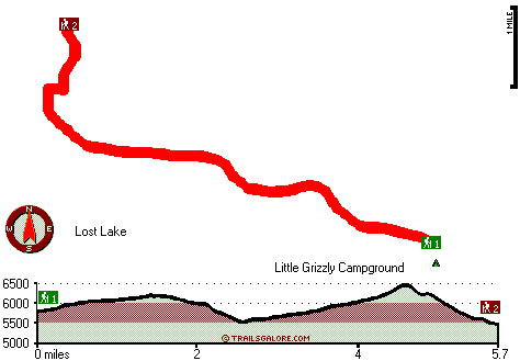
Total hiking length = 5.7 miles
Total climbing distance = 3.4 miles
Difficulty : Medium
Casual Hiking Pace:
5.5 hours
Fast Hiking Pace:
3 hours
Trailhead 2 to Trailhead 1:
Total hiking length = 5.7 miles
Total climbing distance = 2 miles
Difficulty : Medium
Casual Hiking Pace:
5 hours
Fast Hiking Pace:
2.5 hours
| | Trailhead 1 back to Trailhead 1:
Total hiking length = 11.4 miles
Total climbing distance = 5.4 miles
Difficulty : Difficult
Casual Hiking Pace:
1.5 days
Fast Hiking Pace:
7 hours
Trailhead 2 back to Trailhead 2:
Total hiking length = 11.4 miles
Total climbing distance = 5.4 miles
Difficulty : Difficult
Casual Hiking Pace:
1.5 days
Fast Hiking Pace:
7 hours
|
Total elevation difference: 1226 feet
|


