California hiking trails - West Fork Trail, San Gabriel Mountains, San Bernardino County

   
  California has lots of outdoors things to do. There are numerous hiking trails in California, and each one has its own character. Spending too much time indoors got you down? No problem, West Fork Trail in San Bernardino County, California is nature at its best. Summertime at West Fork Trail arrives with high temperatures in the 90's. For the period of the dark hours of summer temperatures drop down into the 50's. The wintertime brings highs down to the 60's while West Fork Trail overnight low temperatures throughout the wintertime are in the 40's.
    West Fork Trail is located a pretty long tour from Los Angeles-Long Beach-Santa Ana, but it is a really brilliant backpacking trail. Even though this is not a very long backpacking and hiking trail you should still bring some emergency supplies just in case something happens. The
amount of rain that falls at West Fork Trail is in the neighborhood of the national average; most of the rain falls during February, and July meanwhile is the driest month. West Fork Trail is a one trailhead hiking and backpacking trail, so in and out is the way to walk it normally. West Fork Trail has a total elevation difference of 927 feet which is a lower than average number. The time needed for this hike is roughly 3 hours, but of course some people walk a bit slower and some a bit faster. There are so many fine hiking trails for backcountry hiking in  
California, and among these are West Fork Trail in San Bernardino County. There's not much difference in elevation along West Fork Trail, so you won’t have to worry about different climate zones along your backcountry trek. This great outdoors hiking trail is on the short side having an average number of uphill miles which makes it a fine backcountry hiking trail for the average person looking for a fine adventure. Being 3.2 miles long it's shorter than many backcountry trails. This is one of many backcountry hiking trails in the surrounding area. This region does get very dry sometimes, so don’t forget to check for any current fire restrictions before you go. These great outdoors hiking trails here in the San Gabriel Mountains are a very good way to see these hills. And keep in mind that there could be temporary safety restrictions in place. When you're here in California backcountry hiking along one of its hiking trails is a perfect way to spend some time.

Briefly about the general area:
The surroundings of this river have so much to offer. There's no way somebody can get bored here in the San Gabriel Mountains. West Fork Trail is a place with many visitors from Los Angeles-Long Beach-Santa Ana, and West Fork Trail is glorious enough to spend more than a day at, Crystal Lake Deer Flats Group - Angeles National Forest is a glorious local campground.
Nearby Cucamonga Canyon is a brilliant location to go if you're at West Fork Trail. There's so much to do here at West Fork Trail that you need to camp here for a while, Crystal Lake - Angeles National Forest is a great place for that.

Location of Trailhead: Latitude 34.1821, Longitude -117.6353
- - Directions and Road Map

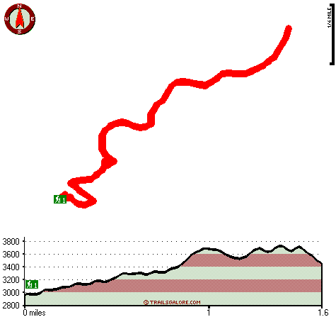
Total in and out hiking length = 3.2 miles

Total climbing distance = 1.3 miles

Difficulty : Medium

Casual Hiking Pace: 3 hours

Fast Hiking Pace: 2 hours

Total elevation difference: 927 feet


Best Western Mountainview Inn & Suites, Upland
5 miles away
  
GuestHouse Inn and Stes Upland, Upland
5 miles away
Located in Southern California just 4.5 miles from the Ontario International Airport, situated at the base of the San Bernardino Mountains, conveniently close to Mt. Baldy and just a few minutes from ...
User input for West Fork Trail, San Gabriel Mountains, San Bernardino County, California:

Submit Input:
Your Name:
Write or Paste Input here:

Upload picture:      Review Guidelines


Outdoors Recreation Near Los Angeles-Long Beach-Santa Ana, California
Very comprehensive list of a variety of outdoors recreation in the vicinity of Los Angeles-Long Beach-Santa Ana, California, the metro area neareast to West Fork Trail. Find info on campgrounds, hiking trails, ski resorts, lakes, beaches, parks, whitewater and more.

Current weather conditions at West Fork Trail, San Gabriel Mountains, San Bernardino County, California
WXPort

Local climate location: POMONA CAL POLY 12 miles away

Hyatt Place Ontario Mills, Ontario
6 miles away
Beautifully appointed guest rooms with separate sitting area and sleeping area. All the rooms have mini refrigerators, wet bar, writing desk, two-line phones with data ports, 42' color HDTV , Free Wif...

Travelodge Ontario, Ontario
6 miles away
The Travelodge Ontario is located with easy access to I-10. The Ontario Mills Shopping Center is only 2.5 miles from the hotel and the Pomona Fairplex is a short 5 mile drive from the hotel. Guests...

More Hotels and Campgrounds Near West Fork Trail, San Gabriel Mountains, San Bernardino County, California

OTHER_INFO
  San Gabriel Mountains Campgrounds
Complete list of all the campgrounds in the San Gabriel Mountains.

San Gabriel Mountains Outdoors Info
Complete outdoors info for the San Gabriel Mountains.

California Hiking Trails
Complete list of all hiking trails in California

Books about hiking trails in California
List of books available on Amazon.com about hiking trails in California.

California Outdoors Index
This is a very comprehensive index of outdoors activities in the great state of California.


TOPO
High quality water resistant topo map of West Fork Trail, San Gabriel Mountains, San Bernardino County, California.

OUTDOORS_GUIDE
These outdoors activities are available near West Fork Trail.
 Trails Near West Fork Trail:
Ontario Peak Trail, San Bernardino County , 3 miles away,  5 hiking miles, 1159 feet elevation difference
Fern Canyon Trail, Los Angeles County , 5 miles away,  13 hiking miles, 455 feet elevation difference
Cucamonga Peak Trail, San Bernardino County , 5 miles away,  10.4 hiking miles, 3105 feet elevation difference
Baldy Trail, Los Angeles County , 5 miles away, 7.5 hiking miles, 7055 feet elevation difference
Pacific Crest Trail - section 7, County , 7 miles away, 52.1 hiking miles, 7647 feet elevation difference
Dawson Peak Trail, Los Angeles County , 7 miles away,  18 hiking miles, 3488 feet elevation difference
Allison Trail, Los Angeles County , 8 miles away,  17 hiking miles, 5495 feet elevation difference
 Camp Grounds Near West Fork Trail:
Crystal Lake - Angeles National Forest, Mt Baldy, 4 miles away
Crystal Lake Deer Flats Group - Angeles National Forest, Mt Baldy, 4 miles away
Table Mountain - Angeles National Forest, Mt Baldy, 4 miles away
Manker Campground, San Bernardino County, 5 miles away
Coldwater Campground, San Bernardino County, 6 miles away
 National Parks Near West Fork Trail:
Mojave National Preserve, Barstow - CA , 57 miles away
 Hotels Near West Fork Trail:
Western Inn, Upland , 5 miles away
Best Western Mountainview Inn & Suites, Upland , 5 miles away
GuestHouse Inn and Stes Upland, Upland , 5 miles away
Hyatt Place Ontario Mills, Ontario , 6 miles away
Travelodge Ontario, Ontario , 6 miles away

Outdoors related information copyright © Stratus-Pikpuk, Inc. - Detailed hotel information copyright © Interactive Hotel Solutions