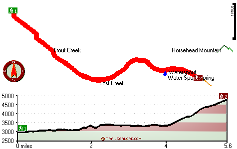
| |
|
| | A visit to California is not complete without some trekking. Backpacking in California is the delightful thing to do. Each one of the many backpacking and hiking trails of California is worth backcountry trekking. Waterspout Trail is a very long way away from society, and you always have a perfect time when you're hiking along it. And keep in mind that there could be temporary safety restrictions in spot. This region does get very dry sometimes, so don’t forget to check for any current fire restrictions before you go. With its 11.2 miles of walking |
|
distance; it's a long great outdoors trail. Can’t wait to get out in the wilderness, Waterspout Trail in Trinity County, California is a really splendid location to spend some time. The total elevation difference for Waterspout Trail is 2,078 feet which is an average number. The
| | amount of rain that falls at Waterspout Trail is in the vicinity of the national average; throughout the month of January you get the most rain around here, and July on the other hand is the driest. This is a hiking and backpacking trail that is quite long, so make sure you bring plenty of supplies. Hiking trails for backcountry trekking, and backpacking can be found all over California, and among these are Waterspout Trail in Trinity County. Backcountry hiking here in the Klamath Mountains is a very fine way to see these peaks. Waterspout Trail goes through | |
|
some very different elevations, and that means that some parts of the great outdoors trail could be very different from other parts of it. This is a neighborhood covered with lots of wilderness trails. Now, this is roughly a 1.5-day backcountry trek, so better have big backpack
to fit all the stuff you need. This backcountry hiking trail is a backcountry hiking trail of fine length with an average amount of climbing distance which makes it a perfect wilderness trail for experienced walkers in pleasant shape. All through the summertime at Waterspout Trail
highs are typically in the 90's with nighttime lows in the 50's. For the period of the wintertime highs are typically in the 40's, and through the dark hours in the wintertime at Waterspout Trail temperatures descend to the 30's. This wilderness trail has two trailheads, so if
you can get a ride from someone, you can backcountry hike it just one way.
Briefly about the general area: All the outdoors entertaining stuff near Waterspout Trail will keep you coming back time and again. Get your heart beating on the wonderful whitewater of Eel River
- North Fork, and swing by Yellowjacket Creek it's a wonderful place to take a look at. Nearby Wrights Valley is a good location to go if you're at Waterspout Trail; a pleasant tour to Penney Glades is a fine way to spend an afternoon. Camping is available at Pine Root Spring
Campground, and do set aside some time for Haynes Delight if you're here at Waterspout Trail. So much cool stuff to do in the Klamath Mountains, not enough time. There's whitewater on Mad River for all you thrill seekers, and why not a little side tour to Willow Creek. Fern
Point is in the vicinity of Waterspout Trail and is a tremendous site to stop by, and a trip to Waterspout will fill your soul with glorious feelings. This place, the Klamath Mountains, has so much outdoors amusing stuff. Why not camp at Hammerhorn Campground if you're here at Waterspout Trail, and do put some time aside to spend at Water Spout Spring if you're here at Waterspout Trail.
|
|
Location of Trailhead 1: Latitude 40.1528, Longitude -123.2142 - - Directions and Road Map
Location of Trailhead 2: Latitude 40.1259, Longitude -123.1406 - - Directions and Road Map

Trailhead 1 to Trailhead 2: Total hiking length = 5.6 miles Total climbing distance = 3.2 miles Difficulty : Medium Casual Hiking Pace:
5.5 hours
Fast Hiking Pace:
3 hours
Trailhead 2 to Trailhead 1: Total hiking length = 5.6 miles Total climbing distance = 1.3 miles Difficulty : Easy Casual Hiking Pace:
4.5 hours
Fast Hiking Pace:
2.5 hours
| | Trailhead 1 back to Trailhead 1: Total hiking length = 11.2 miles Total climbing distance = 4.5 miles Difficulty : Difficult Casual Hiking Pace:
1.5 days
Fast Hiking Pace:
6.5 hours
Trailhead 2 back to Trailhead 2: Total hiking length = 11.2 miles Total climbing distance = 4.5 miles Difficulty : Difficult Casual Hiking Pace:
1.5 days
Fast Hiking Pace:
6.5 hours
|
Total elevation difference: 2078 feet

Super 8 Willits, Willits
|
41 miles away
Welcome to Willits, CA, located in the heart of Mendocino County. Willits offers many activities in and around the community, and gives you firsthand experience of small town America at its finest. ...
|
| |
Lark Motel, Willits
|
41 miles away
Economy motel with clean rooms located on HWY 101 one half mile south of downtown Willits. Close to many dining options. We offer free wireless internet....
|
|
User input for Waterspout Trail, Klamath Mountains, Trinity County, California:

Outdoors Recreation Near Ukiah, California Very comprehensive list of a variety of outdoors recreation in the vicinity of Ukiah, California, the metro area neareast to Waterspout Trail. Find info on campgrounds, hiking trails, ski resorts, lakes, beaches, parks, whitewater and more.
More Hotels and Campgrounds Near Waterspout Trail, Klamath Mountains, Trinity County, California
| |
| |
 |
|
| These outdoors activities are available near Waterspout Trail. |
| | Trails Near Waterspout Trail:
 |
Yellowjacket Trail, Trinity
County
, 2 miles away, 9.6 hiking miles, 1508 feet elevation difference |
 |
Willow Trail, Trinity
County
, 2 miles away, 10 hiking miles, 1081 feet elevation difference |
 |
Doe Ridge Trail, Trinity
County
, 3 miles away, 12.2 hiking miles, 2253 feet elevation difference |
 |
Buck Ridge Trail, Trinity
County
, 3 miles away, 10.6 hiking miles, 3052 feet elevation difference |
 |
Morrison Trail, Trinity
County
, 3 miles away, 10.2 hiking miles, 875 feet elevation difference |
 |
Wrights Valley Trail, Trinity
County
, 5 miles away, 9.4 hiking miles, 1472 feet elevation difference |
 |
Haynes Delight Trail, Trinity
County
, 5 miles away, 12.6 hiking miles, 1310 feet elevation difference |
|
| | Whitewater Near Waterspout Trail:
 |
Mad River, Trinity County
County
, 10 miles away, Class III - 5.8 miles long (North and South Fork confluence to Barry Creek Road) |
 |
Eel River - North Fork, Trinity/ Mendocino County
County
, 12 miles away, Class IV - 12 miles long (Salt Creek to Hulls Creek) |
 |
Eel River - North Fork, Trinity/ Mendocino County
County
, 15 miles away, Class III - 8 miles long (Hulls Creek to Mina Road) |
 |
Hayfork Creek, Trinity County
County
, 17 miles away, Class III - 3.5 miles long (Above Highway 36 to Highway 36) |
 |
Beegum Creek, Shasta / Tehama County
County
, 19 miles away, Class IV-V(V+) - 7 miles long (USFS Campground to State Highway 36) |
|
| | Hotels Near Waterspout Trail:
 |
Super 8 Willits, Willits
, 41 miles away |
 |
Lark Motel, Willits
, 41 miles away |
 |
Clarion Collection Baechtel Creek Inn & Spa, Willits
, 41 miles away |
 |
Baechtel Creek Inn and Spa, Willits
, 41 miles away |
 |
Best Western Willits Inn, Willits
, 41 miles away |
|
|
|
 |
|