California hiking trails - Valley Forge Trail, San Gabriel Mountains, Los Angeles County

   
  You'll have to go far from Los Angeles-Long Beach-Santa Ana to get to Valley Forge Trail, but backpacking trails like these are perfect. Magnificent backcountry hiking trails in California are in abundance, and one of those is Valley Forge Trail in Los Angeles County. While visiting this region in California it's a glorious idea to go backcountry hiking too. You can't spend all your time indoors you need to get out once in a while, and Valley Forge Trail in Los Angeles County, California is just the place. Some parts of this hiking and backpacking trail are
    much higher up than other parts of the hiking and backpacking trail, so keep in mind that you may need to dress differently at different elevations. This is an area covered with lots of wilderness trails. Valley Forge Trail is 3.2 miles long it's shorter than many hiking and backpacking
trails. When you're here in California backcountry trekking along one of its backcountry hiking trails is a glorious way to spend some time. This backcountry trek shouldn't take more than 3 hours, but you never know stuff could go wrong and you could get stuck so be prepared for that. Valley Forge Trail has a total elevation difference of 1,606 feet which is about average. The wonderful hiking trails of the San Gabriel Mountains are the best way to enjoy these mountaintops. Each one of the many backcountry hiking trails of California has its own character.  
Valley Forge Trail is not that long but you should still bring some emergency supplies just in case something happens. This hiking trail is a very short hiking trail with an average amount of climbing distance which makes it a perfect wilderness trail for the average person looking for a perfect adventure. Valley Forge Trail is a one trailhead great outdoors trail, so in and out is the way to walk it normally. Valley Forge Trail gets very little rain; March is the month that gets the most rain, and the driest of the months is July. During the summertime here at Valley Forge Trail, high temperatures usually reach the 90's while night lows are regularly in the 60's. The wintertime brings highs down to the 50's while the cold winter nights at Valley Forge Trail are in the 30's. And keep in mind that there could be temporary safety restrictions in site. At parts of the year this vicinity sees very little rain, so make sure you check current conditions and fire restrictions with local forest authorities before you head out.

Briefly about the general area:
Cedar Canyon is a glorious location to visit in the vicinity of Valley Forge Trail, and if you came for an overnight stay Idlehour Campground is a nice place to camp.
Be careful coming to the San Gabriel Mountains, you might not ever wanna return home again. Lots of folks from Los Angeles-Long Beach-Santa Ana come to Valley Forge Trail, and Mount Lowe Campground is a fine local campground.

Location of Trailhead: Latitude 34.2416, Longitude -118.0928
- - Directions and Road Map

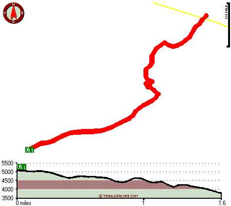
Total in and out hiking length = 3.2 miles

Total climbing distance = 1.3 miles

Difficulty : Medium

Casual Hiking Pace: 3 hours

Fast Hiking Pace: 2 hours

Total elevation difference: 1606 feet


Quality Inn Pasadena, Pasadena
6 miles away
Quietly nestled in the foothills of the majestic San Gabriel Mountians,Quality Inn Pasedena offers all the modern amenities that travlers are looking for and expecting to find in their guest rooms. In...
  
Holiday Inn Express Hotel & Suites PASADENA-COLORADO BLVD., Pasadena
6 miles away
Take a virtual tour of the hotel. The Holiday Inn Express Pasadena Hotel features 81 guest rooms in a four-level parking structure located 1 mile east of the Pasadena Tournament of Rose Parade route, ...
User input for Valley Forge Trail, San Gabriel Mountains, Los Angeles County, California:

Submit Input:
Your Name:
Write or Paste Input here:

Upload picture:      Review Guidelines


Outdoors Recreation Near Los Angeles-Long Beach-Santa Ana, California
Very comprehensive list of a variety of outdoors recreation in the vicinity of Los Angeles-Long Beach-Santa Ana, California, the metro area neareast to Valley Forge Trail. Find info on campgrounds, hiking trails, ski resorts, lakes, beaches, parks, whitewater and more.

Current weather conditions at Valley Forge Trail, San Gabriel Mountains, Los Angeles County, California
WXPort

Local climate location: PALMDALE 6 miles away

Best Western Pasadena Inn, Pasadena
6 miles away
Stay at this Pasadena, California hotel and be in the heart of the action at the Rose Bowl, Rose Parade and events at the Santa Anita Racetrack. The Best Western Pasadena Inn is located on Colorado B...

Best Western Pasadena Royale, Pasadena
6 miles away
Enjoy affordable luxury at this full-service Pasadena, California hotel located minutes away from the Rose Bowl, the Los Angeles Arboretum and the Santa Anita Race Track. Welcome to the Best Western...

More Hotels and Campgrounds Near Valley Forge Trail, San Gabriel Mountains, Los Angeles County, California

OTHER_INFO
  San Gabriel Mountains Campgrounds
Complete list of all the campgrounds in the San Gabriel Mountains.

San Gabriel Mountains Outdoors Info
Complete outdoors info for the San Gabriel Mountains.

California Hiking Trails
Complete list of all hiking trails in California

Books about hiking trails in California
List of books available on Amazon.com about hiking trails in California.

California Outdoors Index
This is a very comprehensive index of outdoors activities in the great state of California.


TOPO
High quality water resistant topo map of Valley Forge Trail, San Gabriel Mountains, Los Angeles County, California.

OUTDOORS_GUIDE
These outdoors activities are available near Valley Forge Trail.
 Trails Near Valley Forge Trail:
Idlehour Trail, Los Angeles County , 2 miles away, 6.2 hiking miles, 2028 feet elevation difference
Gabrielino National Scenic Trail, Los Angeles County , 3 miles away, 19.9 hiking miles, 3843 feet elevation difference
Santa Anita Trail, Los Angeles County , 3 miles away,  4.2 hiking miles, 2891 feet elevation difference
Mount Wilson Trail, Los Angeles County , 3 miles away, 5.6 hiking miles, 4576 feet elevation difference
Winter Creek Trail, Los Angeles County , 4 miles away, 3.2 hiking miles, 2924 feet elevation difference
Upper Winter Creek Trail, Los Angeles County , 4 miles away, 4.8 hiking miles, 3976 feet elevation difference
Condor Peak Riding and hiking Trail, Los Angeles County , 9 miles away,  8.6 hiking miles, 3552 feet elevation difference
 Camp Grounds Near Valley Forge Trail:
Idlehour Campground, Los Angeles County, 2 miles away
Mount Lowe Campground, Los Angeles County, 2 miles away
Henninger Flats Non-Forest Service Campground, Los Angeles County, 3 miles away
Devore Campground, Los Angeles County, 3 miles away
Spruce Grove Campground, Los Angeles County, 4 miles away
 National Parks Near Valley Forge Trail:
Santa Monica Mountains National Recreation Area, Thousand Oaks - CA , 55 miles away
 Hotels Near Valley Forge Trail:
Quality Inn Pasadena, Pasadena , 6 miles away
Holiday Inn Express Hotel & Suites PASADENA-COLORADO BLVD., Pasadena , 6 miles away
Best Western Pasadena Inn, Pasadena , 6 miles away
Best Western Pasadena Royale, Pasadena , 6 miles away
Super 8 Pasadena/LA Area, Pasadena , 6 miles away
 Lakes Near Valley Forge Trail
Eaton Canyon Reservoir, Los Angeles County , 4 miles away

Outdoors related information copyright © Stratus-Pikpuk, Inc. - Detailed hotel information copyright © Interactive Hotel Solutions